Virginia State Route 206
| ||||
|---|---|---|---|---|
| Dahlgren Road | ||||
 | ||||
| Route information | ||||
| Maintained by VDOT | ||||
| Length: | 11.04 mi[1] (17.77 km) | |||
| Existed: | 1933 – present | |||
| Major junctions | ||||
| West end: |
| |||
|
| ||||
| East end: |
| |||
| Location | ||||
| Counties: | King George | |||
| Highway system | ||||
| ||||

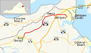
State Route 206 (SR 206) is a primary state highway in the U.S. state of Virginia. Known as Dahlgren Road, the state highway runs 11.04 miles (17.77 km) from SR 3 at Arnolds Corner east to SR 604 at the entrance to the Naval Surface Warfare Center Dahlgren Division in Dahlgren in eastern King George County.
Route description
SR 206 begins at an intersection with SR 3 (Kings Highway) at Arnolds Corner a short distance west of King George, the county seat of King George County. The state highway heads northeast along the height of land between Upper Machodoc Creek to the south and Pepper Mill Creek to the north. After passing through Weedonville, SR 206 leaves the short ridge and crosses Pepper Mill Creek to reach Berthaville, where the highway intersects SR 218 (Caledon Road). The two highways run concurrently east to Owens, where SR 218 turns south as Windsor Drive. SR 206 has an oblique intersection with U.S. Route 301 (James Madison Parkway) then crosses Williams Creek into Dahlgren. After passing through the center of the village, the state highway reaches its eastern terminus at its intersection with SR 604 (Twelfth Street). The roadway continues as unnumbered Dahlgren Road through the gate of the Naval Surface Warfare Center Dahlgren Division.[1][2]
Major intersections
The entire route is in King George County.
| Location | mi[1] | km | Destinations | Notes | |
|---|---|---|---|---|---|
| Arnolds Corner | 0.00 | 0.00 | |||
| Berthaville | 6.44 | 10.36 | West end of concurrency with SR 218 | ||
| Owens | 8.63 | 13.89 | East end of concurrency with SR 218 | ||
| | 9.25 | 14.89 | |||
| Dahlgren | 11.04 | 17.77 | |||
| 1.000 mi = 1.609 km; 1.000 km = 0.621 mi | |||||
References
- 1 2 3 "2010 Traffic Data". Virginia Department of Transportation. 2010. Retrieved 2011-12-05.
- King George County (PDF)
- ↑ Google (2011-12-05). "Virginia State Route 206" (Map). Google Maps. Google. Retrieved 2011-12-05.
External links
| < SR 374 | Spurs of SR 37 1923-1928 |
SR 376 > |
| < SR 611 | District 6 State Routes 1928–1933 |
SR 613 > |