California State Route 123
| ||||
|---|---|---|---|---|
| San Pablo Avenue | ||||
|
Map of California's San Francisco Bay Area with SR 123 highlighted in red | ||||
| Route information | ||||
| Defined by Streets and Highways Code § 423 | ||||
| Maintained by Caltrans | ||||
| Length: | 7.375 mi[1] (11.869 km) | |||
| Major junctions | ||||
| South end: |
| |||
|
| ||||
| North end: |
| |||
| Highway system | ||||
| ||||

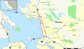
State Route 123 (SR 123) is a state highway in the U.S. state of California in the San Francisco Bay Area. Named San Pablo Avenue for virtually its entire length, SR 123 is a major north–south state highway along the flats of the urban East Bay in the U.S. state of California. Route 123 runs a relatively short 7.39 miles (11.9 km) between Interstate 580 in the south and Interstate 80 in the north. San Pablo Avenue itself, a portion of Historic US 40, continues well past these termini but without the Route 123 designation.
Route description
Route 123 is a four-lane boulevard with a median strip for its entire length. Its southern terminus is at the underpass of Interstate 580 in Oakland. Going north, it passes through the cities of Emeryville, Berkeley, Albany, El Cerrito. It briefly turns on Cutting Boulevard before entering Richmond at its northern terminus under Interstate 80.
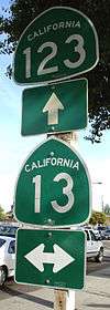
San Pablo Avenue is sometimes used as an alternate route to the Eastshore Freeway (Interstate 80) when that freeway becomes very congested. Major intersections along this route include 40th Street, Ashby Avenue (State Route 13), University Avenue (which leads to UC Berkeley), Gilman Street, Marin Avenue, Central Avenue and Cutting Boulevard.
Continuing on San Pablo Avenue past Route 123's southern terminus eventually leads to downtown Oakland and Oakland City Hall where San Pablo Avenue ends. Continuing on San Pablo Avenue before Route 123's northern terminus leads to the cities of San Pablo, Pinole, Hercules, Rodeo, and Crockett. In Hercules, San Pablo Avenue meets the terminus of State Route 4 near Interstate 80, and, after a discontinuity bridged by Parker Avenue in Rodeo, the road approaches the Carquinez Bridge and arrives in Crockett as Pomona Street.
An AC Transit Rapid Bus (72R-San Pablo Rapid) runs along San Pablo Ave. from Downtown Oakland to Contra Costa College in San Pablo. The express bus line was put in place after a Metropolitan Transportation Commission study determined that it would be more cost-effective than a previous proposal to install light rail along the route. The BART system runs its Richmond leg parallel to the route up to the El Cerrito Del Norte station.
The Alvarado Adobe is located by the San Pablo City Hall on the corner of San Pablo Avenue and Church Lane.
San Pablo Avenue (route descriptions and house numbering)
Independent of its signage as State Route 123, San Pablo Avenue is a high-traffic inter-county artery, linking numerous cities in Alameda and Contra Costa Counties.
- In Oakland, San Pablo Avenue begins at the intersection of 14th Street and Broadway, in the centre of downtown, as a pedestrian path. Shortly before 16th Street, the path becomes a road; the first building given a San Pablo Avenue address is number 1601, assigned to I.B.'s Hoagies and Cheesesteaks. San Pablo Avenue continues as a major artery through the northern border of Oakland, after 67th Street; the highest house number is 6716. Given typical American style, the west (ascending) side of the street is assigned odd numbers.
- The cities of Berkeley and Albany operate on a separate street grid from Oakland. The Berkeley grid increases going south, and the east (also ascending) side of the street is assigned odd numbers, meaning that the highest number along San Pablo Avenue in Berkeley – 3131 – is directly adjacent to number 6716 in Oakland. The lowest number in Berkeley is 1155; the lowest in Albany, 398. Codornices Creek marks the border between Albany and El Cerrito, the Rancho San Pablo and Rancho San Antonio, and thus, Alameda and Contra Costa Counties.
- In El Cerrito, Richmond, and the city of San Pablo, numbers along San Pablo Avenue are assigned as if the numeration were continuous through Berkeley and Albany; unlike Oakland, the numbering along San Pablo Avenue does not reflect the numbering in the rest of any of the cities' grids. Numbering begins at 9800, and ends at 16550, at First Baptist Church of Pinole (a single apparent exception to the below rule).
- State Route 123 turns left from San Pablo Avenue at Cutting Boulevard and terminates at a T-intersection with Interstate 80. San Pablo Avenue north of Cutting is still used as a major artery in its own right.
- Pinole and Hercules, like Berkeley, changes the numbers along San Pablo Avenue to align with its own grid. Numbers start at 500, ascending east-northeast but with odd numbers on the south (descending) side, and ends near 5000 at the intersection of Willow and Parker Avenues in the city of Rodeo.
- San Pablo Avenue turns left to become Parker Avenue in Rodeo, along with numbers corresponding to the numbered streets (Seventh to First Streets, creating numbers from near 730 to number 4) which it intersects as a consequence of turning. Parker Avenue then turns right, named San Pablo again.
- While Parker Avenue is acknowledged as a direct continuation of San Pablo Avenue through Rodeo, a local road at the right turn of Parker Street extends left, also named San Pablo Avenue. Including this portion, the first numbers in San Pablo begin again near 400, ascending east, with odd numbers on the south (descending) side.
- San Pablo Avenue ends at 20050 San Pablo Ave, where the Dead Fish Restaurant is located in Crockett, CA. This number appears to be somewhat arbitrary, possibly inspired by the length of the street overall; this number does not align with the Crockett street grid, and, due to a lack of buildings along San Pablo Avenue between Rodeo and Crockett, does not reflect distance since the number restart in Rodeo.
- San Pablo Avenue directly becomes Pomona Street, and continues for over eight miles (including as Carquinez Scenic Drive, part of which is only a pedestrian path) into downtown Martinez, California, ending at the intersection of Forest and Talbart Streets.
History
San Pablo Avenue is one of the oldest existing roads in the East Bay. It originated in the Spanish colonial era as the Camino de la Contra Costa ("road of the opposite shore", i.e. opposite from the Presidio of San Francisco and the settlement around the Mission in San Francisco) and was legally a "camino real"[2] ("royal road", i.e., property of the Spanish crown) until Mexico won its independence in 1821. It ran from the Encinal ("Oakland") landings of the Rancho San Antonio northward (actually northwestward) along the bayshore, then eastward just inland of the Carquinez Strait. It was the principal thoroughfare for the scattered ranches throughout this part of the East Bay.
The name persisted into the American era when it was still called the "Contra Costa Road". On July 15, 1852, the Court of Sessions of Contra Costa County ordered the construction of a more direct and somewhat improved road along the same general route between the Rancho San Pablo and Oakland,[3] which consequently became known as "The San Pablo Road". This segment subsequently became today's "San Pablo Avenue".
In 1927, this road was designated as part of the Lincoln Highway, the nation's first transcontinental road upon the opening of the new highway bridge across the Carquinez Strait.
Prior to the construction of the Eastshore Highway, San Pablo Avenue was the main north–south route through the northern East Bay, carrying the designation U.S. Route 40 north of University Avenue in Berkeley (US 40 proceeded down to the foot of University and the end of the Berkeley Pier where an auto ferry transported motorists to the Hyde Street Pier in San Francisco). U.S. 40 was moved to the new highway after it was built (1930s), and about 25 years later took its current designation of Interstate 80. San Pablo Avenue was Business U.S. 40 until 1964.
During 2005-06, San Pablo Avenue was repaved and otherwise rehabilitated by Caltrans. Portions of San Pablo Avenue, particularly in Berkeley, Albany, and El Cerrito, are slowly transforming, with a mix of trendy shops, restaurants and condominium developments.
In the early part of the 20th century, a streetcar line ran on San Pablo between Richmond and Oakland. Part of the Oakland segment of these tracks up to Grayson Street in Berkeley were used during World War II for the Shipyard Railway of the Key System which transported workers from the Key System's hub in Emeryville to the Kaiser Shipyards in Richmond.
Major intersections
Except where prefixed with a letter, postmiles were measured on the road as it was in 1964, based on the alignment that existed at the time, and do not necessarily reflect current mileage. R reflects a realignment in the route since then, M indicates a second realignment, L refers an overlap due to a correction or change, and T indicates postmiles classified as temporary (for a full list of prefixes, see the list of postmile definitions).[1] Segments that remain unconstructed or have been relinquished to local control may be omitted. The numbers reset at county lines; the start and end postmiles in each county are given in the county column.
| County | Location | Postmile [1][4][5] | Destinations | Notes | |
|---|---|---|---|---|---|
| Alameda ALA 0.00-5.18 | Oakland | 0.00 | San Pablo Avenue | Continuation beyond I-580 | |
| 0.00 | Interchange; south end of SR 123 | ||||
| Berkeley | 1.91 | ||||
| 3.15 | University Avenue | Serves UC Berkeley | |||
| Contra Costa CC 0.00-2.20 | El Cerrito | 0.29 | Central Avenue | ||
| 2.10 | San Pablo Avenue, Cutting Boulevard | San Pablo Avenue was former US 40 east | |||
| Richmond | 2.20 | Interchange; north end of SR 123 | |||
| 2.20 | Cutting Boulevard – Point Richmond | Continuation beyond I-80 | |||
| 1.000 mi = 1.609 km; 1.000 km = 0.621 mi | |||||
References
- 1 2 3 California Department of Transportation. "State Truck Route List". Sacramento: California Department of Transportation. Archived from the original (XLS file) on June 30, 2015. Retrieved June 30, 2015.
- ↑ Diseño del Rancho de San Pablo, Bancroft Library Collection, circa 1830
- ↑ https://books.google.com/books?id=3hIVAAAAYAAJ&printsec=titlepage#PPA205,M1 History of Contra Costa County, J. P. Munro-Fraser, published by W.A. Slocum, 1882
- ↑ California Department of Transportation, Log of Bridges on State Highways, July 2007
- ↑ California Department of Transportation, All Traffic Volumes on CSHS, 2005 and 2006
External links
| Wikimedia Commons has media related to San Pablo Avenue. |