Stainmore
Coordinates: 54°31′40″N 2°15′35″W / 54.527879°N 2.259772°W / 54.527879; -2.259772
Stainmore is a remote geographic area in the Pennines on the border of Cumbria, County Durham and North Yorkshire.[1][2] The name is used for a civil parish in the Eden District of Cumbria, England, including the villages of North Stainmore and South Stainmore. The parish had a population of 253 in the 2001 census,[3] increasing to 264 at the Census 2011.[4] Stainmore Forest stretches further east into County Durham, towards Bowes.[5]
Geography
Stainmore is drained by the River Belah and the River Balder. It is crossed by the Roman road from Bowes to Brough, now part of the A66, and formerly by the Stainmore Railway. Each of these lines of communication has made use of the relatively low broad saddle between the higher hills to north and south which is commonly referred to as the Stainmore Gap. The summit of the former railway is around 420 metres (1,380 ft) above sea level, though the roads climb to slightly higher elevations.[6] The Gap is coincident with the Stainmore Summit Fault which throws the relatively flat-lying Carboniferous rocks of the area down to the south.[7] It acted as a conduit for Lake District-originated ice to pass eastwards during one or more glacial periods.
There are several RIGS sites in the Stainmore area, and Bowes Moor is a Site of Special Scientific Interest.
History
According to Roger of Wendover, it was where Eric Bloodaxe (d. 954), recently expelled from York, was betrayed and killed, an event which some historians believe to have taken place in a great battle.[8]
Ancient monuments include a Roman marching camp at Rey Cross (54°30′25″N 2°09′19″W / 54.5070°N 2.1552°W / 54.5070; -2.1552 (Rey Cross marching camp)), and the Rey Cross itself (54°30′21″N 2°08′55″W / 54.50579°N 2.14867°W / 54.50579; -2.14867 (Rey Cross)), also called Rere Cross (Scheduled monument, no. 32713).[9]
The Ecclesiastical parish of Brough with Stainmore has two churches: St Michaels, Brough under Stainmore and St Stephens, South Stainmore.[10] St Stephens was built by Cuthbert Buckell in 1600 and rebuilt by Henry Tufton, 11th Earl of Thanet in 1842-3.[11]
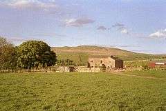
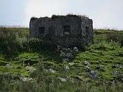
Gallery
References
Further reading
- Collingwood, W.G. "Rey-Cross." Transactions of the Cumberland and Westmorland Antiquarian Archaeological Society series 2, 27 (1927): 1–10.
- Ramsden, D.M. From Stainmore to the Tees. Clapham, 1948.
- Richmond, I.A. and McIntyre, J. "The Roman marching camps at Reycross and Crackenthorpe." Transactions of the Cumberland and Westmorland Antiquarian Archaeological Society series 2, 34 (1934): 50–61.
- Robinson, P. Archaeology on the Stainmore Pass – the A66 Project. Barnard Castle, 1993.
- Vyner, B. (ed.). Stainmore. The Archaeology of a North Pennine Pass. Tees Archaeology Monographs 1. Hartlepool, 2001.
 |
Wikimedia Commons has media related to Stainmore. |
|
|---|
|
Cumbria Portal |
|
| Boroughs or districts | |
|---|
|
| Major settlements | |
|---|
|
| Topics | |
|---|