Stafford Regional Airport
| Stafford Regional Airport | |||||||||||
|---|---|---|---|---|---|---|---|---|---|---|---|
 | |||||||||||
| IATA: none – ICAO: KRMN – FAA LID: RMN | |||||||||||
| Summary | |||||||||||
| Airport type | Public | ||||||||||
| Owner/Operator | Stafford Regional Airport Authority | ||||||||||
| Location | Stafford, Virginia | ||||||||||
| Elevation AMSL | 211 ft / 64 m | ||||||||||
| Coordinates | 38°23′53″N 077°27′20″W / 38.39806°N 77.45556°W | ||||||||||
| Map | |||||||||||
 KRMN  KRMN | |||||||||||
| Runways | |||||||||||
| |||||||||||
| Statistics (2004) | |||||||||||
| |||||||||||
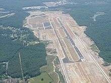
Stafford Regional Airport (ICAO: KRMN, FAA LID: RMN) is a public airport located three miles (5 km) southwest of the central business district of Stafford, the county seat of Stafford County, Virginia, United States.[1] The airport is southwest of the intersection of Route 630 and U.S. Route 1 near Interstate 95, approximately 40 miles (64 km) south of Washington, D.C. and 60 miles (97 km) north of Richmond. It is owned and operated by the Stafford Regional Airport Authority, an independent body of representatives from Stafford and Prince William Counties and the City of Fredericksburg.[2]
Although most U.S. airports use the same three-letter location identifier for the FAA and IATA, Stafford Regional Airport is assigned RMN by the FAA but has no designation from the IATA (which assigned RMN to Rumginae, Papua New Guinea).[3][4]
Facilities and aircraft
Stafford Regional Airport covers an area of 566 acres (229 ha) which contains one asphalt paved runway (15/33) measuring 5,000 x 100 ft (1,524 x 30 m). For the 12-month period ending December 31, 2004, the airport had 7,667 aircraft operations, an average of 21 per day: 93% general aviation and 7% military.[1]
Accidents
The airport was the site of a fatal accident on February 22, 2006, involving a Lancair Columbia 400 piloted by a private pilot.[5] The pilot and three passengers were killed when the aircraft flew into trees surrounding the runway after an aborted landing attempt via ILS.[6] Following an investigation, the NTSB cited pilot error as the most likely cause of the accident.[7]
References
- 1 2 3 FAA Airport Master Record for RMN (Form 5010 PDF), effective 2007-07-05
- ↑ Stafford Regional Airport website, retrieved 2007-10-08.
- ↑ Great Circle Mapper: KRMN - Stafford, Virginia (Stafford Regional Airport)
- ↑ Great Circle Mapper: RMN - Rumginae, Papua New Guinea
- ↑ Abstract of NTSB reference NYC06FA072 (February 26, 2007).
- ↑ NTSB reference NYC06FA072 (February 26, 2007).
- ↑ Freehling, B., “Report Faults Pilot”, The Free Lance-Star, February 28, 2007.
External links
- Resources for this airport:
- FAA airport information for RMN
- AirNav airport information for KRMN
- FlightAware airport information and live flight tracker
- NOAA/NWS latest weather observations
- SkyVector aeronautical chart, Terminal Procedures