St Lawrence Parish, Cumberland
| St Lawrence New South Wales | |||||||||||||
|---|---|---|---|---|---|---|---|---|---|---|---|---|---|
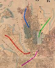 Location in Sydney city highlighted in magenta | |||||||||||||
| Established | 1835 | ||||||||||||
| LGA(s) | City of Sydney | ||||||||||||
| County | Cumberland | ||||||||||||
| Hundred (former) | Sydney | ||||||||||||
| |||||||||||||
St Lawrence Parish is one of the 57 parishes of Cumberland County, New South Wales, Australia, a cadastral unit for use on land titles. It is one of the four small parishes in the Sydney city area. Unlike the other three parishes, St Lawrence was not named after a church, but instead due to confusion over the naming, the parish gave its name to the Christ Church St Laurence. This had been controversial in the 19th century, as it meant the Anglican church was given a Catholic saint's name.[1]
The area of the parish includes Central station, Museum station, the southern part of Hyde Park below Park street, and Prince Alfred Park. The parish is bounded by George Street in the west, Park Street and a small part of William Street in the north, a line from the intersection of Yurong and William streets to the intersection of Albion and Elizabeth Street in the east, also part of Elizabeth Street forms the boundary further south, as well as Chalmers Street. Regent Street is the boundary in the south west.[2] It includes the ANZAC War Memorial.[3] The parish is relatively thin east-west, so that Central railway station nearly covers the entire width of the parish.
Images
Images of locations in the Parish of St Lawrence:

 ANZAC War Memorial, and the surrounding southern part of Hyde Park
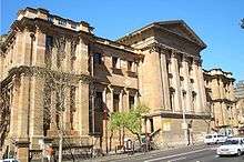 The Australian Museum is at the north-eastern tip of the parish
Coordinates: 33°52′26″S 151°12′23″E / 33.87389°S 151.20639°E
References
- "St Lawrence". Geographical Names Register (GNR) of NSW. Geographical Names Board of New South Wales.