St Giles, London
| St Giles | |
 St Giles High Street, January 2012 |
|
 St Giles |
|
| OS grid reference | TQ300811 |
|---|---|
| – Charing Cross | 0.5 mi (0.8 km) S |
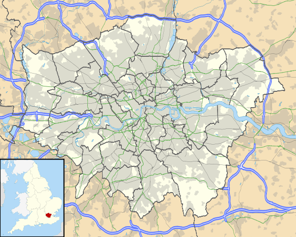
| London borough | Camden |
| Ceremonial county | Greater London |
| Region | London |
| Country | England |
| Sovereign state | United Kingdom |
| Post town | LONDON |
| Postcode district | WC1, WC2 |
| Dialling code | 020 |
| Police | Metropolitan |
| Fire | London |
| Ambulance | London |
| EU Parliament | London |
| UK Parliament | Holborn and St Pancras |
| London Assembly | Barnet and Camden |
Coordinates: 51°30′51″N 0°07′37″W / 51.5143°N 0.1270°W
St Giles is a district of London, at the southern tip of the London Borough of Camden. It was formerly the parish of St Giles in the Fields and the combined parishes of St Giles in the Fields and St George Bloomsbury formed the St Giles District of the Metropolis from 1855 to 1900.[1] It is the location of the church of St Giles in the Fields, the Phoenix Garden and St Giles Circus. With Bloomsbury and Holborn, it is part of the "Midtown" business improvement district.
History
There has been a church at St Giles since Saxon times, located beside a major highway.[2] The hospital of St Giles, recorded c. 1120 as Hospitali Sancti Egidii extra Londonium was founded, together with a monastery and a chapel, by Queen Matilda, wife of Henry I.[3] St Giles (c. 650 – c. 710) was the patron saint of lepers and the hospital was home to a leper colony, the site chosen for its surrounding fields and marshes separating contagion from nearby London. Peter Ackroyd argues that the character of vagrancy has never left the area.[2]A village accreted to cater to the brethren and patients. The crossroads which is now St. Giles Circus, where Oxford Street, Charing Cross Road, Tottenham Court Road and New Oxford St meet, was the site of a gallows until the fifteenth century.[2] Grape Street, in the heart of the St Giles district, runs beside the site of the hospital's vineyard.[2]
The monastery was dissolved during the Reformation and a parish church created from the chapel. The hospital continued to care for lepers until the mid sixteenth century, when the disease abated and the hospital instead began to care for indigents.[4][5] The parish was known as St Giles in the Fields and it is recorded in 1563 as Seynt Gyles in the Field.[6] The first post-Catholic parish church was built in 1631 and from the mid-seventeenth century church wardens note "a great influx of poor people into this parish".[2] The cellars in particular were already recorded as horrific places in which whole families resided, "damp and unwholesome" as the village was built on marshland. The Parliamentary Act of 1606 had condemned the area as "deepe foul and dangerous" . Vagrants expelled from the city settled in the St Giles district known for the generous charitable relief of the parish. Irish and French refugees were drawn to the area as well as "St Giles blackbirds", black servants reduced to begging.[2]
The 1665 Great Plague started in St Giles and the first victims were buried in the St. Giles churchyard.[2] By September 1665, 8000 people were dying a week in London. By the end of the plague year there were 3,216 listed plague deaths in St Giles parish, which had fewer than 2,000 households.[7] After the Restoration, the area was populated by Huguenot refugees who had fled persecution and established themselves as tradesmen and artisans, particularly in weaving and the silk trade.[3]
The southern area of the parish, around present day Shaftesbury Avenue, was a wasteland named Cock and Pye Fields. Houses were not built there until 1666, after the Great Fire, and not fully developed until 1693, becoming known as Seven Dials. Thomas Neale built much of the area, giving his name to Neal Street and Neal's Yard. St Giles and Seven Dials became known for their astrologers and alchemists, an association which lasts to this day.[2] The village of St Giles stood on the main road from Holborn to Tyburn, a place of local execution. Convicted criminals were often allowed, in tradition, to stop at St Giles en route to Tyburn for a final drink - a "St Giles Bowl" - before hanging.[2][3]
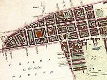
The rookery
As London grew in the 18th and 19th centuries, so did the parish's population, rising to 30,000 by 1831.[4] The Rookery stood between the church and Great Russell Street, and Seven Dials near where Centre Point stands today, now home to the Centrepoint homeless charity.[4][8] It was of one of the worst slums within Britain, a site of overcrowding and squalor, a semi-derelict warren. From Georgian affluence in the 18th century, the area declined rapidly, as houses were divided up, many families sharing a single room. Irish Catholic immigrants seeking to escape desperate poverty took up residence and the slum was nicknamed "Little Ireland" or "The Holy Land".[8]The expression "a St Giles cellar" passed into common parlance, describing the worst conditions of poverty.[8] Open sewers often ran through rooms and cesspits were left untended. Residents complained to the Times in 1849 : "We live in muck and filth. We aint got no priviz, no dust bins, no drains, no water-splies, and no drain or suer in the hole place." [9] The rookery was a maze of gin shops, prostitutes' hovels and secret alleyways that police had little of hope navigating. William Hogarth, Thomas Rowlandson, and Gustav Dore, among others, have drawn the area, novelists Henry Fielding and Charles Dickens. Romance novelists Elizabeth Hoyt and Erica Monroe have written about it extensively in their Maiden Lane and Rookery Rogues series, respectively.[8] Peter Ackroyd writes "The Rookeries embodied the worst living conditions in all of London's history; this was the lowest point which human beings could reach".[2]
Reformer Henry Mayhew described the slum in 1860 in A Visit to the Rookery of St Giles and its Neighbourhood: "The parish of St. Giles, with its nests of close and narrow alleys and courts inhabited by the lowest class of Irish costermongers, has passed into a byword as the synonym of filth and squalor. And although New Oxford Street has been carried straight through the middle of the worst part of its slums—"the Rookery"—yet, especially on the south side, there still are streets which demand to be swept away in the interest of health and cleanliness… They [are] a noisy and riotous lot, fond of street brawls, equally "fat, ragged and saucy;" and the courts abound in pedlars, fish-women, newscriers, and corn-cutters." [3] As the population grew, so did their dead, the area a home to cholera and consumption. Eventually there was no room in their grave yard, so during the eighteenth and nineteenth centuries, many were buried in the cemeteries surrounding St Pancras.
From the 1830s to the 1870s plans were developed to demolish the slum as part of London wide clearances for improved transport routes, sanitation and the expansion of the railways. New Oxford Street was driven through the area to join the areas of Oxford Street and Holborn. The Rookery dwellers were not re-housed by the authorities. 5000 were evicted and many just moved into nearby slums, such Devil's Acre and Church Lane making those more overcrowded still. The unchanging character of the area, failing investment schemes and inability to sell new properties ensured that plans for wholesale clearance were stymied until the end of the century.[10][11]
Local governance


The ancient parish of St Giles in the Fields formed part of the Ossulstone hundred of Middlesex.[1] The parish of St George Bloomsbury was split off in 1731, but the parishes were combined for civil purposes in 1774 and used for the administration of the Poor Law after the Poor Law Amendment Act 1834. George Buchanan was appointed Health Officer for the parish around 1856.[12] Upon the creation of the Metropolitan Board of Works in 1855 the combined parishes became the St Giles District and were transferred to the County of London in 1889.
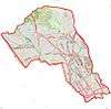
The St Giles civil parish was an elongated "L" shape, stretching from Torrington Place in the north to Shelton Street in the south and then east to include Lincoln's Inn Fields. For registration, and therefore census reporting, the civil parish was divided in North and South districts, with Monmouth Street broadly forming the division. The length of St Giles High Street is identical to the width of the parish at that point. The parish of St George Bloomsbury was located to the northeast. In 1881 the population of St Giles North was 13,837[13] and St Giles South was 14,864.[14]
The local government of London was reorganised in 1900 and St Giles became part of the Metropolitan Borough of Holborn. Since 1965 it has been part of the London Borough of Camden.[1]
Hogarth depictions of St Giles
"Four Times of Day"


The etching "Four Times of Day" by Hogarth takes place in Hog Lane, with the church of St Giles in the Fields in the background. Hogarth would feature St Giles again as the background of Gin Lane and First Stage of Cruelty. The picture shows the Huguenot refugees who arrived in the 1680s and established themselves in the silk trade; Hogarth contrasts their fussiness and high fashion with the slovenliness of the group on the other side of the road; the rotting corpse of a cat that has been stoned to death lying in the gutter that divides the street is the only thing the two sides have in common. The older members of the congregation wear traditional dress, while the younger members wear the fashions of the day. The children are dressed up as adults: the boy in the foreground struts around in his finery while the boy with his back to the viewer has his hair in a net, bagged up in the "French" style.[15] At the far right, a black man, probably a freed slave, fondles the breasts of a woman, distracting her from her work,[16] her pie-dish "tottering like her virtue".[17] In front of the couple, a boy has set down his pie to rest, but the plate has broken, spilling the pie onto the ground where it is being rapidly consumed by an urchin.[18]
"Gin Lane"

Set in St Giles, "Gin Lane" depicts the squalor and despair of a community raised on gin. The only businesses that flourish are those which serve the gin industry: gin sellers; distillers; the pawnbroker where the avaricious Mr. Gripe greedily takes the vital possessions (the carpenter offers his saw and the housewife her cooking utensils) of the alcoholic residents of the street in return for a few pennies to feed their habit; and the undertaker, for whom Hogarth implies at least a handful of new customers from this scene alone. Most shockingly, the focus of the picture is a woman in the foreground, who, addled by gin and driven to prostitution by her habit —as evidenced by the syphilitic sores on her legs— lets her baby slip unheeded from her arms and plunge to its death in the stairwell of the gin cellar below. Half-naked, she has no concern for anything other than a pinch of snuff. This mother was not such an exaggeration as she might appear: in 1734, Judith Dufour reclaimed her two-year-old child from the workhouse where it had been given a new set of clothes; she then strangled it and left the infant's body in a ditch so that she could sell the clothes (for 1s. 4d.) to buy gin.[19] In another case, an elderly woman, Mary Estwick, let a toddler burn to death while she slept in a gin-induced stupor.[20] Other images of despair and madness fill the scene: a lunatic cavorts in the street beating himself over the head with a pair of bellows while holding a baby impaled on a spike—the dead child's frantic mother rushes from the house screaming in horror; a barber has taken his own life in the dilapidated attic of his barber-shop, ruined because nobody can afford a haircut or shave; on the steps, below the woman who has let her baby fall, a skeletal pamphlet-seller rests, perhaps dead of starvation, as the unsold moralising pamphlet on the evils of gin-drinking, The Downfall of Mrs Gin, slips from his basket.[21]
"First stage of cruelty"
Set in St Giles, the etching shows a boy, Nero, is being assisted by other boys torturing a dog by inserting an arrow into a its rectum. An initialled badge on the shoulder of his light-hued and ragged coat shows him to be a pupil of the charity school of the parish of St Giles. A more tender-hearted boy, perhaps the dog's owner,[22] pleads with Nero to stop tormenting the frightened animal, even offering food in an attempt to appease him.[23]
Modern governance
St Giles is split between the electoral wards of Bloomsbury and Holborn and Covent Garden in the London Borough of Camden. With some sections of Holborn and Bloomsbury it forms part of the Midtown business improvement district. It is within the Holborn and St Pancras Parliament constituency and the Barnet and Camden London Assembly constituency. For elections to the European Parliament it is part of the London constituency.
Tottenham Court Road tube station

The Central London Railway (CLR) opened Tottenham Court Tube Station, between the Church of St Giles in the Fields and St Giles Circus on 30 July 1900.[24] Tottenham Court Road underwent improvements in the early 1930s to replace lifts with escalators. The station had four entrances to the sub-surface ticket hall from the north-east, south-west and north-west corners of St Giles Circus and from a subway beneath the Centrepoint building which starts on Andrew Borde Street. The entrances were frequently congested leading to occasions during peak periods of the day when they were briefly closed to prevent overcrowding in the station.
In 2009, Transport for London began a major reconstruction of large parts of the station. Much of the St Giles area alongside St Giles High Street has been cleared to make way for the new development including Crossrail expansion.[25] The Astoria theatre on Charing Cross Road has been demolished and the original Central line entrances will also go.[25]
See also
- Church of St Giles in the Fields
- St Giles Circus
- St Giles District (Metropolis)
- Central Saint Giles
- The Phoenix Garden
References
- 1 2 3 Youngs, Frederic (1979). Guide to the Local Administrative Units of England. I: Southern England. London: Royal Historical Society. ISBN 0-901050-67-9.
- 1 2 3 4 5 6 7 8 9 10 London: A Biography (2000) Ackroyd, Peter Chatto and Windus p131-140
- 1 2 3 4 Thornbury, Walter (1878) "Old and New London: Volume 3" pp. 197-218. " XXVI. St Giles in the Fields"
- 1 2 3 St Giles in the Fields: History
- ↑ British History Online 'Religious Houses: Hospitals', A History of the County of Middlesex: Volume 1: Physique, Archaeology, Domesday, Ecclesiastical Organization, The Jews, Religious Houses, Education of Working Classes to 1870, Private Education from Sixteenth Century (1969), pp. 204-212. URL: http://www.british-history.ac.uk/report.aspx?compid=22122. Date accessed: 3 January 2008.
- ↑ Mills, D. (2000). Oxford Dictionary of London Place Names. Oxford.
- ↑ Museum of London
- 1 2 3 4 Guardian article "London parish's descent from glamour to grime charted in exhibition" 16 May 2011
- ↑ Letter to The Times complaining of their living conditions, written by residents of St Giles" 17 May 2011
- ↑ Victorian London (2005) Picard, Liza. Weidenfeld and Nicholson p26
- ↑ White, Jerry (2007) London in the 19th Century Vintage pp30-34
- ↑ Sally, Sheard (2006). The Nation's Doctor. Radcliffe Publishing. p. 181. ISBN 1846190010.
- ↑ http://www.visionofbritain.org.uk/data_cube_page.jsp?data_theme=T_POP&data_cube=N_TOT_POP&u_id=10565133&c_id=&add=N
- ↑ http://www.visionofbritain.org.uk/data_cube_page.jsp?data_theme=T_POP&data_cube=N_TOT_POP&u_id=10564451&c_id=&add=N
- ↑ Cooke and Davenport. Vol.1 Noon (1821). The Works of William Hogarth. London: J.Sharpe.
- ↑ "The Four Times of the Day". Museum of London. Retrieved 18 January 2007.
- ↑ "The African Community in London". Museum of London. Retrieved 18 January 2007.
- ↑ Uglow, Jenny (1997). Hogarth: a life and a world. Faber and Faber. p.83 ISBN 0-571-16996-1.
- ↑ George p.41
- ↑ Warner, Jessica (2002). Craze: Gin and Debauchery in an Age of Reason. Thunder's Mouth Press. ISBN 1-56858-231-5. p.69
- ↑ Clerk, Thomas (1812). The Works of William Hogarth. 2. London: Scholey.p29
- ↑ Sean Shesgreen (1974). Engravings by Hogarth: 101 Prints. New York: Dover Publications, Inc.
- ↑ John Ireland (1833). "Four stages of cruelty". Anecdotes of William Hogarth, Written by Himself: With Essays on His Life and Genius, and Criticisms on his Work. J.B. Nichols and Son. pp. 233–40.
- ↑ Clive's Underground Line Guides - Central Line, Dates
- 1 2 Crossrail - Proposal for eastern ticket hall
External links
![]() Media related to St Giles High Street at Wikimedia Commons
Media related to St Giles High Street at Wikimedia Commons
History of the formation of the London Borough of Camden | ||
|---|---|---|
| Metropolitan boroughs |  | |
| District boards | ||
| Parishes | ||