St. Joseph Valley Parkway
| St. Joseph Valley Parkway | |
|---|---|
| Route information | |
| Maintained by INDOT, MDOT | |
| Length: | 56.34 mi[lower-alpha 1] (90.67 km) |
| Component highways: |
|
| Major junctions | |
| East end: |
|
|
| |
| North end: |
|
| Location | |
| States: | Indiana, Michigan |
| Counties: | IN: Elkhart, St. Joseph MI: Berrien |
| Highway system | |
|
| |
The St. Joseph Valley Parkway is a freeway in the U.S. states of Indiana and Michigan, serving as a bypass route around Elkhart, Mishawaka, and South Bend in Indiana and Niles in Michigan. The freeway runs to the south and west of Elkhart and South Bend and Niles and consists of segments of U.S. Route 31 (US 31) and US 20; those two highway designations run concurrently at the southwestern rim of the South Bend metropolitan area. It continues north to run along the St. Joseph River valley.
The freeway was first built in Indiana in the 1960s, although plans in Michigan date back to the 1950s. Indiana completed its portion of the freeway in 1998, while Michigan has opened its last segment in 2003. Further plans, if completed, would extend the freeway from the current end to the north. The ultimate end will either be at the interchange between Interstate 196 (I-196) and I-94 as originally planned, or another interchange immediately to the southwest. Environmental and other issues have forced a re-evaluation of the original 1981 plans for the northern end of the freeway.
Route description
The Parkway begins where US 20 expands to a divided highway southeast of Elkhart. To the east in Indiana the freeway feeds into an undivided segment of US 20 at County Road 17 (CR 17). From there it runs westward along the south sides of Elkhart and Mishawaka. South of South Bend, US 31 joins the Parkway, and then the Parkway turns northward along the west side of South Bend. Along this segment, US 20 turns back west and leaves the Parkway. The Parkway meets the Indiana Toll Road which carries I-80/I-90 before crossing the state line into Michigan.[1] West of Niles, the Parkway meets US 12 and continues northwesterly running west of Berrien Springs. From there it runs northward to end at Napier Avenue east of St. Joseph. The St. Joseph Valley Parkway ends at Napier Avenue, but US 31 continues as a five-lane highway west along Napier to connect with I-94 and the rest of the US 31 routing north of there on I-196.[2]
The Indiana Department of Transportation (INDOT) and the Michigan Department of Transportation (MDOT) both maintain the sections of the St. Joseph Valley Parkway in their respective states. Additionally, both departments have listed their freeway segments as part of the National Highway System, a system of roads important to the nation's economy, defense, and mobility.[3][4] The two departments conduct surveys to measure the traffic levels along their roadways. This measurement is expressed in terms of annual average daily traffic (AADT) which is a calculation of the traffic volume on a stretch of roadway for any average day of the year. INDOT's figures for 2007 showed that 30,753 vehicles used the freeway near its western end. The traffic volume drops to 19,914 vehicles near the Indiana Toll Road.[5] In Michigan, the levels drop as low as 7,402 vehicles near the Napier Road interchange.[6]
History
Name
The "St. Joseph Valley Parkway" name was chosen by local chambers of commerce in the fall of 1992 as the result of a local contest held by a group of local businesses. The name was officially adopted by Michigan in 1993 (dedicated late 1995) and Indiana in 1995 (dedicated in mid-1995).[7][8]
Indiana section
The first section of the St. Joseph Valley Parkway was completed between US 20 and State Road 2 (SR 2) by 1962.[9] The freeway was extended to SR 23 and construction was started to extend it further to US 31. The freeway was given the Bypass US 20 (BYP US 20) designation at this time as well. This extension to US 31 was completed in the mid-1970s. The exit with the Indiana East–West Toll Road/I-80/I-90 was finished in 1979. The BYP US 20 designation was replaced by the US 31 designation in 1982. Construction in the early 1990s extended the freeway in sections from US 31/Business US 31 (Bus. US 31) to its current end with US 20 at CR 17, with the portion from US 31/Bus. US 31 to SR 331 (Bremen Highway) paved first, by 1991. Ramps from Nimtz Parkway were completed in 1998, and the portion in Elkhart was also named the "Dean R. Mock Expressway" in March 2002.[10][11]
Michigan section
A plan to relocate US 31 in Berrien County, Michigan, existed as early as 1952.[12] Planning to extend the South Bend Bypass northward into Michigan as a bypass of Niles began in 1967. A report issued in 1970 detailed four routing corridors, spawning a lawsuit over how Berrien Springs would be bypassed. Construction was to begin in 1975, but the Michigan State Highways Department delayed construction plans in 1972, pushing the start to 1977. The first section was completed in 1979 and ran from the state line north to US 12. From there, US 31 was routed east along US 12 to Bus. US 12 and north along Bus. US 12 to the former routing of US 31/US 33. Final plans for the routing north to I-94 were approved in 1981. Construction of the Niles Bypass was finished in 1987, bringing the freeway north to Walton Road northwest of Niles. Bus. US 31 was created along the former routing in Niles and Walton Road was rebuilt as a state trunkline connection between the northern end of the freeway and the former two-lane routing of US 31. The Berrien Springs Bypass was opened in late 1992.[13] Since then, MDOT built a 9.1-mile (14.6 km) freeway segment north to Napier Avenue that was opened on August 27, 2003 at a cost of $97 million (equivalent to $137 million in 2015[14]).[15][16]
Future
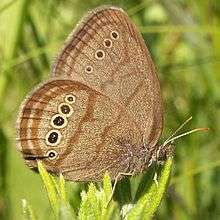
East of Benton Harbor, Michigan, the St. Joseph Valley Parkway extension was under study due to environmental, economical and historical site issues. One of the environmental concerns relates to the habitat of an endangered species, the Mitchell's Satyr butterfly that has its habitat in the area of the freeway extension.[17] The 40-acre (16 ha) habitat is home to the second-largest population of the rare butterfly.[18] This freeway connection was originally approved in 1981 as part of a final environmental impact study that included the freeway built from Niles northward to Napier Avenue.[19] Since that approval, the butterfly was discovered in the Blue Creek Fen in the late 1980s,[20] and it was listed an endangered species in 1992. The listing stalled construction of the freeway north of Berrien Springs.[13] The US Fish and Wildlife Service (USFWS) issued an opinion two years later that the freeway project would jeopardize the species.[20] MDOT was given permission to modify the previously approved freeway to cross the Blue Creek on longer bridges; the USFWS also required that any construction be done from elevated platforms,[21] among other restrictions.[18] In the interim, MDOT proceeded with construction of the southern portion of the last freeway segment, completing the freeway northward from Berrien Springs to the Napier Avenue interchange in August 2003.[15]
A revised environmental impact study to account for the butterfly's habitat was approved in 2004.[20] The study compared the original proposal for this extension that involved connecting directly to I-196 at I-94 with a pair of alternate routines that involved connecting US 31 directly to BL I-94 at I-94 near Benton Harbor with auxiliary lanes to I-196. The recommendation was to use the PA-2 version of the alternative connection to avoid the Blue Creek Fen.[22] At the time the last freeway segment was opened in 2003, MDOT expected the remaining segment would not take much longer to complete,[17] but funding was not available for many years.[23] Construction of the extension was not included for this reason in subsequent MDOT five-year highway projects plans, although most of the design work and land acquisition was identified in 2013 as having been finished.[24] Funding for the project was listed in the 2017–21 plan draft released in July 2016, which split the remaining work into three phases.[25][26] Until the freeway is complete, US 31 follows a stretch of Napier Avenue, which was upgraded in conjunction with the St. Joseph Valley Parkway opening to that point, westward to I-94.[2] The US 31/I-94/BL I-94 interchange will be converted to a cloverleaf interchange if a connection is completed in the future,[27] and the St. Joseph Valley Parkway name has already been applied to this unbuilt section.[28]
Exit list
| State | County | Location | mi[lower-alpha 2] | km | Exit | Destinations | Notes |
|---|---|---|---|---|---|---|---|
| Indiana | Elkhart | Jefferson–Concord township line | 98.65 | 158.76 | 99 | Old US 20 – Elkhart | Eastern terminus as US 20 becomes a freeway |
| Elkhart | 95.55 | 153.77 | 96 | Northern terminus of US 33 | |||
| Concord–Baugo township line | 92.04 | 148.12 | 92 | ||||
| St. Joseph | Penn Township | 84.75 | 136.39 | 86 | Eastern end of SR 331 concurrency | ||
| 82.75 | 133.17 | 84 | Western end of SR 331 concurrency | ||||
| South Bend | 81.27 | 130.79 | 82 | Ironwood Drive | |||
| 78.47– 78.83 | 126.29– 126.86 | 79 | Southern end of US 20/US 31 concurrency; milepost 253.94 on US 31; signed as exits 79A (Bus. US 31) and 79B (US 31) | ||||
| 76.08 | 122.44 | 76 | |||||
| Portage Township | 74.38 | 119.70 | 74 | Mayflower Road | Northbound only exit for westbound traffic | ||
| 72.51– 72.88 | 116.69– 117.29 | 73 | Signed as exits 73A (west, South Bend) and 73B (east, LaPorte) | ||||
| South Bend | 70.53 262.24 | 113.51 422.03 | 71 | Northern end of US 20/US 31 concurrency | |||
| 263.02 | 423.29 | 264A | Nimtz Parkway | ||||
| 263.93 | 424.75 | 264B | Exit 72 on Indiana Toll Road | ||||
| 264.87 | 426.27 | 265 | |||||
| 266.02 0.000 | 428.12 0.000 | Indiana–Michigan state line | |||||
| Michigan | Berrien | Bertrand Township | 3.287 | 5.290 | 3 | ||
| Niles Charter Township | 4.852 | 7.809 | 5 | Niles–Buchanan Road | |||
| 6.777 | 10.907 | 7 | Walton Road | Former Bus. US 31 | |||
| Oronoko Charter Township | 12.987 | 20.901 | 13 | Snow Road – Berrien Springs | |||
| 15.474 | 24.903 | 15 | |||||
| Sodus Township | 18.080 | 29.097 | 18 | Tabor Road | |||
| 21.938 | 35.306 | 22 | Sodus Parkway | ||||
| Benton Charter Township | 24.441 | 39.334 | 24 | Northern terminus of St. Joseph Valley Parkway; US 31 continues on Napier Avenue | |||
1.000 mi = 1.609 km; 1.000 km = 0.621 mi
| |||||||
See also
-
 Indiana portal
 -
 Michigan Highways portal
 -
 U.S. Roads portal
Footnotes
- ↑ Total mileage is a summation of the state mileages.
- ↑ Milepost numbers reset at the Indiana–Michigan state line crossing. In Indiana concurrent sections and exits use the US 20 mileposts which increase to the east.[29][30]
References
- ↑ Indiana Department of Transportation (2009). Indiana Transportation Map (Map) (2009–10 ed.). Indianapolis: Indiana Department of Transportation. §§ A6–A8.
- 1 2 Michigan Department of Transportation (2010). Uniquely Michigan: Official Department of Transportation Map (Map). c. 1:975,000. Lansing: Michigan Department of Transportation. §§ M7–N7. OCLC 42778335, 639960603.
- ↑ Federal Highway Administration (March 5, 2010). National Highway System: South Bend Indiana (PDF) (Map). Washington, DC: Federal Highway Administration. Retrieved November 23, 2010.
- ↑ Michigan Department of Transportation (April 23, 2006). National Highway System, Michigan (PDF) (Map). Lansing: Michigan Department of Transportation. Retrieved October 7, 2008.
- ↑ Staff (2007). "Indiana Average Daily Traffic and Commercial Vehicles". Indiana Department of Transportation. Retrieved November 23, 2010.
- ↑ Bureau of Transportation Planning (2008). "Traffic Monitoring Information System". Michigan Department of Transportation. Retrieved November 20, 2010.
- ↑ Barnett, LeRoy (2004). A Drive Down Memory Lane: The Named State and Federal Highways of Michigan. Allegan Forest, MI: The Priscilla Press. p. 196. ISBN 1-886167-24-9. OCLC 57425393.
- ↑ "Bypass Is Now Parkway". South Bend Tribune. July 26, 1995. OCLC 8793233.
- ↑ Gil Schaefer (1961). Rand McNally Michigan Road Atlas: Boat Launching Sites, Fishing & Hunting Guide, Winter Sports Facilities (Map) (5th ed.). Scale not given. Grand Rapids, MI: Gil Schaefer Distributor. OCLC 269804701.
- ↑ Staff. "Memorial Highways and Bridges". Indiana Department of Transportation. Archived from the original on December 15, 2010. Retrieved October 28, 2010.
- ↑ DeAgostino, Martin (March 21, 2002). "Retiring Lawmaker Rides Road to Fame; Plan to Rename Parkway, Killed in State Senate, Is Resurrected". South Bend Tribune. OCLC 8793233. Retrieved April 27, 2008 – via ProQuest Archiver. (subscription required (help)).
- ↑ Aiken, Scott (September 1, 2002). "US 31 Construction: End of the Road in Sight". The Herald-Palladium. St. Joseph, MI. OCLC 34793533. Retrieved November 25, 2008. (subscription required (help)).
- 1 2 "Michigan Butterfly Snarls US 31 Traffic". Science Notebook. Milwaukee Journal. March 14, 1993. p. J2. ISSN 1052-4452. OCLC 298956108. Retrieved December 8, 2013 – via Google News.
- ↑ United States nominal Gross Domestic Product per capita figures follow the Measuring Worth series supplied in Johnston, Louis; Williamson, Samuel H. (2016). "What Was the U.S. GDP Then?". MeasuringWorth. Retrieved April 10, 2016. These figures follow the figures as of 2015.
- 1 2 Aiken, Scott (August 23, 2003). "Better Late than Never: US 31 Freeway Finally Reaches Twin Cities". The Herald-Palladium. St. Joseph, MI. pp. 1A, 6A. OCLC 34793533. Retrieved November 25, 2008.
- ↑ Martin, Julie A. (August 27, 2003). "US 31 in Berrien County Opens Today!" (Press release). Michigan Department of Transportation. Archived from the original on December 25, 2011. Retrieved March 26, 2013.
- 1 2 Aiken, Scott (October 20, 2013). "When, Oh When, Will 31 Be Done? MDOT Says Linking the Freeway to I-94 East of Benton Harbor Is Years Away". The Herald-Palladium. Benton Harbor, MI. Archived from the original on April 1, 2014. Retrieved November 13, 2013.
- 1 2 Greenberg, Joel (2004). A Natural History of the Chicago Region. Chicago: University of Chicago Press. pp. 302–3. ISBN 978-0-2263-0648-3. OCLC 48803715. Retrieved December 8, 2013 – via Google Books.
- ↑ Project Planning Division (April 2004). "Section 1.0 Summary of the 1981 Final Environmental Impact Statement for the US 31 Freeway in Berrien County" (PDF). Final Supplemental Environmental Impact Statement to the 1981 Final Environmental Impact Statement, Proposed US 31 Freeway Connection to I-94 (PDF). Michigan Department of Transportation. p. 1-1.
- 1 2 3 Project Planning Division (April 2004). "Section 4.0 Affected Environment" (PDF). Final Supplemental Environmental Impact Statement to the 1981 Final Environmental Impact Statement, Proposed US 31 Freeway Connection to I-94 (PDF). Michigan Department of Transportation. pp. 4–1, 4–8.
- ↑ "Bridge OK Could Save a Butterfly". Chicago Tribune. Knight-Ridder. April 24, 1994. Retrieved December 8, 2013.
- ↑ Project Planning Division (April 2004). "Executive Summary" (PDF). Final Supplemental Environmental Impact Statement to the 1981 Final Environmental Impact Statement, Proposed US 31 Freeway Connection to I-94 (PDF). Michigan Department of Transportation. p. iii.
- ↑ Haroldson, Tom (September 4, 2013). "MDOT Officials Concerned Funding Issues Can Delay, Kill Needed Projects". Kalamazoo Gazette. Archived from the original on April 1, 2014. Retrieved September 5, 2013.
- ↑ Lersten, Andrew (September 5, 2013). "Don't Hold Your Breath". The Herald-Palladium. St. Joseph, MI. Archived from the original on April 1, 2014. Retrieved September 5, 2013.
- ↑ "Rep. Pscholka: U.S. 31 Back on the Build List and on MDOT's Five Year Plan" (Press release). Michigan House Republicans. July 5, 2016. Retrieved July 6, 2016.
- ↑ Matuzak, John (July 6, 2016). "Back from the Dead". The Herald-Palladium. St. Joseph, MI. Retrieved July 6, 2016.
- ↑ Project Planning Division (April 2004). "Section 3.0 Alternatives Considered" (PDF). Final Supplemental Environmental Impact Statement to the 1981 Final Environmental Impact Statement, Proposed US 31 Freeway Connection to I-94 (PDF) (Report). Michigan Department of Transportation. Figure 3.1, p. 3-3.
- ↑ Staff. "All Memorial Highways". Michigan Department of Transportation. Retrieved March 8, 2008.
- ↑ Staff (2004). Reference Post Book (PDF). Indianapolis: Indiana Department of Transportation. U-20, U-31. Retrieved August 6, 2010.
- ↑ Michigan Department of Transportation & Michigan Center for Shared Solutions and Technology Partnerships (2009). MDOT Physical Reference Finder Application (Map). Michigan Department of Transportation. Retrieved August 6, 2010.
External links
- US 31 Freeway in Berrien County at Michigan Highways