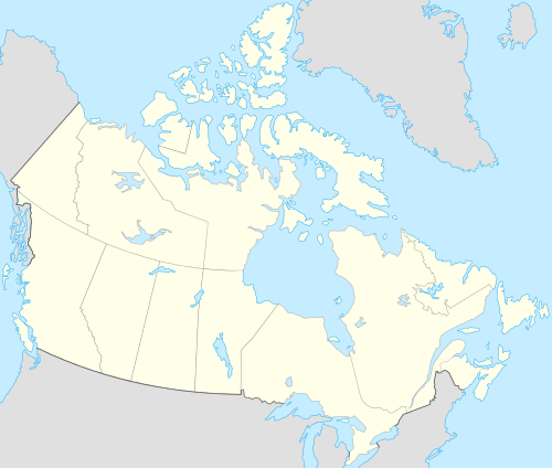
St. Joseph Island (Ontario)
| Native name: <span class="nickname" ">Anipich or Payentanassin (Ojibwe)[1] Nickname: St. Joe | |
|---|---|
 St. Joseph Island | |
| Geography | |
| Location | Lake Huron, east of the mouth of the St. Marys River. |
| Coordinates | 46°13′11″N 83°56′47″W / 46.21972°N 83.94639°WCoordinates: 46°13′11″N 83°56′47″W / 46.21972°N 83.94639°W[2] |
| Archipelago | Manitoulin archipelago |
| Area | 365 km2 (141 sq mi) |
| Length | 30 km (19 mi) |
| Width | 20 km (12 mi) |
| Highest elevation | 335 m (1,099 ft) |
| Highest point | Carterton |
| Administration | |
|
Canada | |
| Province | Ontario |
| District | Algoma District |
| Largest settlement | Richards Landing |
| Demographics | |
| Population | 1,844[3] (2011) |
| Pop. density | 5.05 /km2 (13.08 /sq mi) |
St. Joseph Island is located in northern Ontario, Canada in northwestern Lake Huron. At 365 km2, it is the second largest island on Lake Huron, following Manitoulin Island, and the third largest of all the islands on the Great Lakes, trailing Manitoulin and Lake Superior's unpopulated Isle Royale.
By road, the island is approximately 68 km (42 mi) south east of the city of Sault Ste. Marie and 273 km (170 mi) west of Sudbury.
St. Joseph Island played an important role for First Nations and Europeans in the early fur trade and as a staging point for the first victory for British North America in the War of 1812. Today it is a destination for tourists and cottagers in northeastern Ontario.
History

Aboriginal People
Unlike neighbouring islands, little evidence has been found of early human activity on St. Joseph Island. Archeologists have found very little to confirm settlement, farming or hunting on the island before the 17th century.[4]
It is speculated that the first humans to see St. Joseph Island and set foot on it were the hunter-gatherers of the Plano cultures who travelled north from the Great Plains of the continent between 9000 BCE and 6000 BCE. These peoples followed the bison and other animals into the areas revealed by retreating glaciers. Evidence of Plano migrations – particularly projectile point tools - has been found in the Great Lakes basin from Lake Superior through the St. Marys River to the north channel of Lake Huron.
By about 5000 BCE, St. Joseph Island would have formed part of the boundary between the Laurentian Archaic and the Shield Archaic peoples. The Laurentian people, hunters and fishers who came from the southeast settled in the lower St. Lawrence and eastern Great Lakes region. The Shield people, likely descendants of the Plano came south from the Tyrrell Sea (a much larger Hudson Bay) and travelled along the northern shores of lakes that are today Superior and Huron.[5]
European Exploration
By the time the first Europeans arrived in the 1630s, the north channel of Lake Huron was shared by the Ojibwe, Odawa and Potawatomi whose Algonkian ancestors had come from the east around 1200. St. Joseph Island became a strategic mid-way point for French explorers, missionaries and fur traders on the long voyage between Quebec and Lake Superior. In addition to its geographic convenience, St. Joseph Island would have offered opportunities for fishing, hunting and gathering seasonal native berries.[6]
St. Joseph Island first appeared on European maps in the 1670s. A map by French explorer René de Bréhant de Galinée labels it “Anipich”, after a Ojibwe word meaning "place of the hardwood trees".[7] Later the Ojibwe would call the island "Payentanassin" as well.[8] But by the 1740s the island came to be called "Saint Joseph" by Europeans, presumably so-named by Jesuit missionaries in honour of the church they were building on the island.[9]
British North America and Fort St. Joseph
Any claim that France may have had to all or any portion of St. Joseph Island ended with the conclusion of the Seven Years' War in 1763. Under the terms of treaty, France relinquished virtually all of its interests in North America to the British. For the first time, the British and their First Nation allies were unchallenged on the Great Lakes. Included in the French assets was the strategically important fort at the Strait of Mackinac between lakes Huron and Michigan 50 km (31 mi) west of St. Joseph Island. From here, the British were able to control the flow of trade in and out of Lake Michigan.

However, British superiority on the lakes did not last long. By 1783 the Treaty of Paris effectively ended the American Revolution. The border it created between the United States and British North America ran “through the middle of said Lake Huron to the water communication between that Lake and Lake Superior...”[10]
While the treaty very clearly placed Mackinac Island on the American side, it was equally unclear how St. Joseph and its neighbouring islands that fell in the middle of the St. Marys River were to be apportioned. For instance, an influential map produced by American engraver Abel Buell based on the treaty instructions appears to divide St. Joseph in half. For a time, the British exploited this uncertainty as well as the relatively weak American administration in its newly acquitted territory, to keep its garrison at Fort Mackinac while it sought to secure a base of operations that would allow it to protect its claim to the fur trade and retain influence with the aboriginal peoples.[11] The Governor General, Lord Dorchester sent a team of British Royal Engineers to survey the area from the Straits of Mackinaw to Lake Superior to attempt to clarify the boundary left unclear by the Treaty of Paris and to locate a suitable site for a new fort.[12]
In his report, the chief surveyor wrote “St. Joseph’s [sic] Island is a very fine island about 27 miles long, one of a numerous group that lies in the straits separating Lake Huron from Lake Superior. It is naturally fertile and well suited to cultivation but not so well fitted for military purposes. However, I have claimed it for the British crown and built a stockade.”[13] On April 11, 1796, Dorchester ordered a garrison of 14 men to set up a camp on the southwest corner of the island close to the channel between Mackinac and Sault Ste. Marie.[14] This advance detachment, led by Lieutenant Foster of the Queen's Rangers identified a spot of high ground nearby to suitable for a fort.[15] In accordance with the Jay-Grenville Treaty of 1794, the British abandoned Mackinac Island in June 1796 to establish a new fort on the southeastern corner of St. Joseph Island.
On June 30, 1798, the Ojibwe agreed to sell the island to the British for £1,200 Quebec currency of trade goods, an annual gift exchange and the right to continue to harvest the island and bury their dead there.[16]
In time, Fort St. Joseph became an important point for trade and commerce in the region. Settlers, many of whom had lived near the fort at Mackinac as well as merchants of the Northwest Company followed the garrison to establish the first permanent European settlement on the island around Fort St. Joseph.
At the start of the War of 1812, Fort St. Joseph was the most westerly British outpost in Upper Canada. Within weeks of the commencement of hostilities, the British moved a force from Fort St. Joseph to reclaim their old fort at Mackinac. Abandoned, Fort St. Joseph was burned by a U.S. force in July 1814.[17] As a result of shifting strategic considerations and the decline of the fur trade, the British did not rebuild the Fort St. Joseph following the war. In 1974, the ruins became a National Historic Site administered by Parks Canada.
Border on the Great Lakes
British and American negotiators to the 1814 Treaty of Ghent ended the war by offering no territorial concessions to either side, but returned to those boundaries set by the Treaty of Paris. However, in order to resolve territorial claims that had precipitated the war, negotiators at Ghent established a process whereby commissioners would survey the boundary to determine the borders envisioned in the original treaty.

Beginning in August 1820, two teams of surveyors, including British explorer and cartographer David Thompson, mapped the area of St. Joseph Island, Drummond Island, and Lesser and Greater Manitou Islands (today Cockburn Island and Manitoulin Island). Mapping this corner of Lake Huron was a challenge given how little was actually known about the shores and depths of the channels between the islands. The agent for the American survey team, Major Joseph Delafield complained “No map that I have seen has any truth as it respects the position of Drummond’s or the other islands about St. Marys. We entered this bay without a pilot, but are told we cannot proceed up river without one.”[11]
Based on the surveys taken in the summers of 1820 and 1821, and guided by the Commission's two principles that the boundary would not divide islands and that the number of islands would be apportioned equally between the two countries,[11] in November and December 1821, commissioners agreed to grant St. Joseph Island and Cockburn Island to Canada and Drummond Island between them to the United States.[11] Importantly, it also placed the border along the western shore of St. Joseph between it and St. Tammany (today Neebish) Island.[18]
However, the commissioners were unable to agree on where the border should go upon exiting the channel between St. Joseph and St. Tammany. This question would wait until the 1842 Webster-Ashburton Treaty finally established the boundary “along the ship channel between Saint Joseph and St. Tammany Islands, to the division of the channel at or near the head of St. Joseph's Island [sic]; thence, turning eastwardly and northwardly, around the lower end of SE George's or Sugar Island”[19] so as to assign Sugar Island in the United States.
Settlement of St. Joseph Island
From the end of the war until 1829, St. Joseph Island was virtually uninhabited. Exploring a creek in the southeast corner of the island, one of the commission survey teams reported "a neat log house far up in the woods, with a patch of Indian corn, and other vegetables. It was inhabited by an Indian widow and her daughter. Nothing could exceed the cleanliness of the lodge in the wilderness. The surveyors saw no one else on the island and reported it as a jungle containing only bears and other wild animals."[20]
The boundary commission process, combined with the demilitarization of the Great Lakes under the Rush–Bagot Treaty of 1817, offered greater certainty in the region. Increasingly St. Joseph Island and its environs began to be seen for their abundant resources and potential for settlement.
Among the first to see this potential was Major William Rains. A veteran of British wars in Europe, Rains resigned the military in 1830 to start a new life in British North America. In 1834, Lieutenant Governor John Colborne allowed Rains to purchase over 2,200 hectares to start a colony on St. Joseph Island. Rains, his family and a company of investors established Milford Haven - named after Rains' hometown in Wales - complete with a store and saw mill in the southeast of the island. However, few settlers came to the island and by 1839 the community consisted of only eight houses.[21] Rains became estranged from his fellow investors and relocated to a point of land not far from the site of Fort St. Joseph. Rains' wife Frances and her sister Eliza bore nineteen[22] of Rains’ children, many of whom remained in the area.[23] His son Tudor Rains would go on to establish a successful store at Sailors Encampment on the northwest of the island.[24]
The population of the island began to shift from the south and west to better agricultural land in the north.[25] Government policies including the Free Grants and Homestead Act of 1868, encouraged would-be farmers in the south of Ontario to relocate to tracts of land in Algoma by providing up to two hundred acres of land per head of household.[26] The greatest influx of settlers came between 1874 and 1882.[27]
John Richards moved to St. Joseph Island from Sault Ste. Marie in 1876 and founded Richards Landing. Two years later, businessman John Marks moved from Bruce Mines and founded Marksville, which was incorporated as the Village of Hilton Beach in 1923.[27]
Two lumber mills began operating on the island in the early 1880s. Shortly after 1910, the Stone Lumber Company at Marksville had added 13 km of railroad with a locomotive to reach dense woodlots up the mountain and deliver timber to the mill. For a time both the train and mill were operated around the clock. By the end of the decade, the mill had produced and shipped two and a half million board feet of lumber around the world.[28]
The completion of the Canadian Pacific Railway spur from Sudbury across the north channel to Sault Ste. Marie in 1887 opened up the region to migration by farmers and settlers. A rough roadway followed so that by 1923, the communities along the channel were connected to Sault Ste. Marie by road.
Electrical power came to St. Joseph Island in the 1930s, with a few commercial and residential customers connected in Richards Landing and Hilton Beach in the summer of 1933. The community of Kentvale was included later in the decade. Street lights were installed in the villages in 1947.[29]
Beginning in 1953, a government-run diesel ferry, the “St. Joseph Islander," operated from Humbug Point providing free, 24-hour access to the island for residents, cottagers and tourists.[30] Before this, Islanders had relied upon two cable ferries. The first began operating in 1919 and ran on a 610 metre cable between Campement D’Ours Island and the mainland. The second ferry, the “Magic Carpet” operated from Pine Island to the mainland. In 1934, both ferries were sold to the provincial government which began providing a free service.[31]
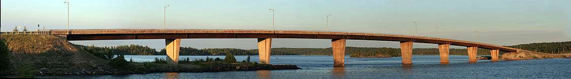
The ferry was retired in 1972 when a bridge was constructed. In December 1994, the bridge was named the Bernt Gilbertson St. Joseph Island Bridge in honour of Bernt Gilbertson, an island resident and member of provincial parliament who had long petitioned for the bridge.[32]

Geography and geology

St. Joseph Island is located near the mouth of the St. Marys River in northwestern Lake Huron. It is the most westerly of the Manitoulin chain of islands.
The island was formed by debris and erosion at the end of the last glacial period. As the Laurentide ice sheet, a huge glacier extending into the present-northern United States, melted about 11,000 years ago, it carved deep gouges into the earth, scraped off top soil and deposited rock and sand. It also allowed land compacted by the weight of the ice to rise. The Great Lakes were created when their north shore rebounded from the retreating ice, capturing glacial run off. The land mass that is St. Joseph Island today emerged 5,000 years ago, its shorelines carved out by glacial water which formed what is today the St. Marys River and Lake Huron that surround the island.[33]
On its longest - northeast-southwest - axis the island is about 30 km (19 mi) and about 20 km (12 mi) at its widest point.[34] Its highest point is in the centre of the island near Carterton with an elevation of 345.6 m, which is about 169 m above Lake Huron.[35] This peak, known colloquially and by surveyors as “the Mountain”, is a glacial moraine of rock debris pushed by a glacial lobe before it receded.[36] The Mountain is of particular interest to geologists as it would have been an island itself during the glacial Lake Algonquin period about 10,000 years ago.[35]
St. Joseph Island sits on top of the Canadian Shield and is surrounded by outcrops of it on the mainland to the north. However, this distinctive rock formation is little evident on the island itself.[37]
A creation of Precambrian rivers and later metamorphism, "puddingstone" or jasper conglomerate, distinctive for its bright red and brown jasper pebbles suspended in white quartzite, is found on the island.
Government
St. Joseph Island is organized into three townships, the Township of Hilton, the Township of Jocelyn, the Township of St. Joseph, and the Village of Hilton Beach. St. Joseph Township was the first to be incorporated on November 20, 1876 with Hilton and Jocelyn townships following in 1886. In May 1923, Hilton Beach separated from Hilton Township and was organized as a police village.[38]
Island residents are represented in the Legislative Assembly of Ontario by the Member of Provincial Parliament for the electoral district of Algoma-Manitoulin.
Federally, the island is represented in the House of Commons by the Member of Parliament for the electoral district of Sault Ste. Marie. However, in the redistribution of federal electoral districts that followed the 2011 census, the commission recommended removing St. Joseph Island from the riding that includes the City of Sault Ste. Marie and returning it to the more rural Algoma—Manitoulin—Kapuskasing riding because the island has “some community of interest with other similar-sized communities along Highway 17” in that electoral district.[39]
Demographics
St. Joseph Island had a year-round population of 1,844 in 2011.[40] Nearly two-thirds of the population (63%) is between the ages of 15 to 64, over a quarter (27%) is 65 or older, and ten per cent are children under the age of 15. The median age for the island is 56.3.
According to census data, the population of the island peaked at 1,996 residents at the beginning of the 1900s following a 75 per cent increase from a decade earlier. The population trend then declined to just over 1,100 residents in 1966. Since then the island's permanent population increased to a new high of 1,997 residents in 1996. The majority of the population (approximately 1,200 residents) reside in St. Joseph Township at the island's north end. The largest population centre on St. Joseph Island is the village of Richards Landing on the island's northern shore.
| 1881 | 1891 | 1901 | 1911 | 1921 | 1931 | 1941 | 1951 | 1956 | 1961 | 1966 | 1971 | 1976 | 1981 | 1986 | 1991 | 1996 | 2001 | 2006 | 2011 | |
|---|---|---|---|---|---|---|---|---|---|---|---|---|---|---|---|---|---|---|---|---|
| Township of Hilton | 415 | 389 | 407 | 378 | 522 | 237 | 182 | 96 | 100 | 116 | 105 | 94 | 126 | 144 | 173 | 231 | 255 | 258 | 243 | 261 |
| Township of Jocelyn | 413 | 369 | 452 | 337 | 344 | 226 | 196 | 176 | 144 | 137 | 98 | 104 | 119 | 144 | 170 | 238 | 294 | 298 | 277 | 237 |
| Township of St. Joseph | 409 | 367 | 1,137 | 1,098 | 1,017 | 1,032 | 908 | 804 | 839 | 902 | 776 | 861 | 983 | 1,061 | 1,054 | 1,180 | 1,235 | 1,201 | 1,129 | 1,201 |
| Village of Hilton Beach | - | - | - | - | - | 214 | 182 | 206 | 145 | 155 | 165 | 165 | 222 | 228 | 210 | 217 | 213 | 174 | 172 | 145 |
| TOTAL | 1,237 | 1,125 | 1,996 | 1,813 | 1,883 | 1,709 | 1,468 | 1,282 | 1,228 | 1,310 | 1,144 | 1,224 | 1,450 | 1,577 | 1,607 | 1,866 | 1,997 | 1,931 | 1,821 | 1,844 |
During the summer months, the influx of seasonal cottagers can boost the island’s population to between 4,000 and 10,000.[44]
Culture
St. Joseph Island’s appeal as a tourist destination has contributed to a culture that mixes its rural charm with a lively arts scene.
Among the regular arts events are Arts on the Dock held in Hilton Beach and the Canadian Arts Festival in Richards Landing in July, and Arts and Artifacts at the St. Joseph Island Museum in August. Two events organized in the spring and fall by the local arts community invite people to visit the home studios and shops of artists around the island.
The island is also home to Canadian landscape artist Doug Hook, whose watercolour paintings, often of island scenes, are found in the collections of prominent individuals including His Royal Highness the Prince of Wales.[45]
Particularly in the summer months St. Joseph Island draws live musical acts from across Canada and the United States.
The population is served by three libraries. The St. Joseph Township Public Library and the Florence Orrell Children’s Library are located in Richards Landing and the Hilton Union Public Library is located in Hilton Beach.
There are a number of service clubs and volunteer associations that organize popular events and meetings, including the Lions Club, Matthews Memorial Hospital Association, St. Joseph Island Arts Association, St. Joseph Island Historical Association and the Royal Canadian Legion, Branch 374.
A weekly newspaper, the Island Clippings, has published since 1995 and is distributed through retailers and home mail delivery on the island.
Economy
Maple syrup
An abundance of maple trees and family tradition contribute to St. Joseph Island being the largest center of maple syrup production in the province of Ontario. There are over a dozen maple syrup producers operating on St. Joseph Island, including Gilbertson’s Maple Products and Thompson’s Maple Products.[46]
In the early years of settlement maple sugar was exported in large quantities. Over 2,041 kg were sent to Amherstburg in 1798 and 454,000 metric tons to Detroit in 1839.[47]
Tourism
Tourism is the primary source of income on St. Joseph Island. The island is a popular tourist destination, especially for cottagers from nearby Sault Ste. Marie, and visitors from the United States. Most of the island is privately owned, with many seasonal cottages situated near Richards Landing and Hilton Beach.
Festivals and events geared towards the tourist economy are held throughout the year, including the annual Maple Syrup Festival in Richards Landing, Arts at the Dock in Hilton Beach, the Great Canadian Arts Festival and Canada Day Tractor Trot in Richards Landing, private arts and craft sales, the St. Joseph Island Triathlon and the annual community nights in Richards Landing and Hilton Beach.
Attractions include Fort St. Joseph national historical site, maintained by Parks Canada, and the St. Joseph Island Museum.
Farming
Many small family farms or hobby farms operate on the island producing corn and other vegetables, beef, lamb, poultry and eggs.[48] Güenter Schmidt and his son Kenton ran a pheasant preserve on the island for many years, contributing to a healthy pheasant population today. The island is also popular for hunting and fishing.
Education
Throughout the history of settlement on St. Joseph Island, many small schools operated in various places across the Island. However, since 1964 all elementary age students have attended the St. Joseph Island Public School in Richards Landing. Following years of community organizing and fundraising, the St. Joseph Island District High School opened in Richards Landing in 1960. It was operated by the Township of St. Joseph through the 1960s until 1972 when the opening of the bridge to the mainland coincided with the opening of the newly constructed Central Algoma Secondary School in nearby Desbarats on the mainland.[49]
Elementary students from Junior Kindergarten to Grade six on the island attend St. Joseph Island Central School in Richards Landing. Students in Grades 7 to 12 attend Central Algoma Secondary School in Desbarats. School buses operate all over the island to take children to classes. Both St. Joseph Island Central School and Central Algoma Secondary School are administered by the Algoma District School Board.
Transportation
Water
.jpg)
Until the construction of the bridge in 1972, residents and tourists relied on watercraft to reach the island. Many waterfront cottages and homes have docks to service small motor boats and pleasure craft.
Tourists can dock at municipal marinas that operate at Hilton Beach and Richards Landing. The Hilton Beach Marina consists of over 160 slips, with approximately 30 available to visiting boats.[50] The Richards Landing Municipal Marina has 70 slips and is a Canada Border Services Agency check-in point.[51]
St. Joseph Island is located along the northwest shipping channel of the St. Marys River. Large freighters heading towards Sault Ste. Marie and on to Lake Superior pass between the west side of St. Joseph Island with Michigan’s Upper Peninsula and Neebish Island on the other. Ships on the channel eventually make a wide westerly turn at Stribling Point at St. Joseph’s northern-most point.
Air
The St. Joseph Island Airport is a private airstrip located about half way between Richards Landing and Hilton Beach consisting of a 732 m (2,402 ft) turf runway.
Road
The primary road system to and on the island is Highway 548, a 75 km (47 mi) secondary highway consisting of two separate segments: the north-south segment, that includes the St. Joseph Island Bernt Gilbertson Bridge, and a continuous loop route that circles the island.
The north-south segment connects with Highway 17/Trans Canada Highway in the north and terminates at a T-intersection with the loop segment at Kent's Corners, 5.4 kilometres (3.4 mi) south of Highway 17.
The much longer 68 km (42 mi) continuous loop segment circles the island. To assist in navigation and street addressing, segments of the loop have been given suffix letters which generally correspond to the local road name. For example, the portion of Highway 548 which is signed along D Line is named 548D, along Huron Line it is named 548H, etc.[52]
The much smaller Campement d'Ours Island, located at the north side of the island is connected to St. Joseph Island by a small bridge and causeway.
E.H. Pitkin Cottage
E.H. Pitkin Cottage is a cottage built on Sapper Island, a small island on the northwest end of St. Joseph's Island. It is one of two buildings on the remote island.
Built in 1900-1902 for Chicago businessman Edward Hand Pitkin (1846-1918) by Frank Lloyd Wright, it is the only surviving building built by the American architect in Canada.[53]
Pitkin sold the home in 1916 to another American buyer, James Heyworth, who passed down the home to Heyworth's grand-daughter Tica Marquandt and now remains in her family.[54]
See also
References
Notes
- ↑ "St. Joseph Island". "The Canadian Encyclopedia". Historica Foundation of Canada. Retrieved 25 October 2012.
- ↑ "The Atlas of Canada". Retrieved 2012-10-04.
- ↑ Statistics Canada. "2011 Census: Population and Dwelling Counts". Retrieved 5 November 2012.
- ↑ John Roblin Abbott; Graeme Stewart Mount; Michael J. Mulloy (2000). The History of Fort St. Joseph. Dundurn. p. 17. ISBN 1550023373.
- ↑ John Roblin Abbott; Graeme Stewart Mount; Michael J. Mulloy (2000). The History of Fort St. Joseph. Dundurn. p. 19. ISBN 1550023373.
- ↑ John Roblin Abbott; Graeme Stewart Mount; Michael J. Mulloy (2000). The History of Fort St. Joseph. Dundurn. p. 28. ISBN 1550023373.
- ↑ "Algoma Towns and Cities". Retrieved 18 February 2013.
- ↑ Joseph E. and Estelle L. Bayliss. River of Destiny: The Saint Marys. Wayne University Press, Detroit. 1955. p. 120.
- ↑ "St. Joseph Island". "The Canadian Encyclopedia". Historica Foundation of Canada. Retrieved 20 January 2013.
- ↑ The Paris Peace Treaty of September 30, 1783. Lilian Goldman Law Library, Yale Law School. Accessed 21 July 2013 http://avalon.law.yale.edu/18th_century/paris.asp
- 1 2 3 4 Carroll, Francis M. (Fall 2004). "The Search for the Canadian-American boundary along the Michigan frontier, 1819-1827: The Boundary Commissions under Articles Six and Seven of the Treaty of Ghent". Michigan Historical Review. 30 (2): 77–104.
- ↑ H.J.L. Wooley. The Sword of Old St. Joe: Historical Sketches. Unknown publisher. 19??. http://ebooks.library.ualberta.ca/local/theswordofoldstj00wooluoft
- ↑ H.J.L. Wooley. The Sword of Old St. Joe: Historical Sketches. Unknown publisher. 19??. p.2
- ↑ Joseph E. and Estelle L. Bayliss. River of Destiny: The Saint Marys. Wayne University Press, Detroit. 1955. p.121.
- ↑ Joseph E. and Estelle L. Bayliss. River of Destiny: The Saint Marys. Wayne State University, Detroit. 1955. p. 121
- ↑ Joseph E. and Estelle L. Bayliss. River of Destiny: The Saint Marys. Wayne University Press, Detroit. 1955. p. 122. and John Abbott, Graeme S. Mount, and Michael J. Mulloy. The History of Fort St. Joseph. Dundurn Group, Toronto. 2000. p. 31.
- ↑ Dale, Ronald J. "Fort St Joseph National Historic Site of Canada". The Canadian Encyclopedia. Retrieved 20 February 2013.
- ↑ "Reports of International Arbitral Awards: Declaration and decision of the Commissioners of Great Britain and the United States, under Article VI of the Treaty of Ghent of 1814, respecting Boundaries, relating to lakes Ontario, Erie and Huron and River St. Lawrence. 18 June 1822" (PDF). VOLUME XXVIII pp.11-16. United Nations. Retrieved 20 February 2013.
- ↑ "British-American Diplomacy: The Webster-Ashburton Treaty". Yale Law School: Avalon Project. Retrieved 27 February 2013.
- ↑ Joseph E. and Estelle L. Bayliss. River of Destiny: The Saint Marys. Wayne University Press, Detroit. 1955. p. 70.
- ↑ "He Had an Eye for the Fairer Sex". Town of Georgina. Retrieved 18 March 2013.
- ↑ "SJHS # 600048 - RAINS FAMILY". Retrieved 19 March 2013.
- ↑ Andrea Gutsche, Barbara Chisholm & Russell Floren (1997). The North Channel and St. Marys River: a guide to the history. Lynx Images Inc. pp. 162–163. ISBN 1-894073-00-2.
- ↑ Andrea Gutsche, Barbara Chisholm & Russell Floren (1997). The North Channel and St. Marys River: a guide to the history. Lynx Images Inc. p. 185. ISBN 1-894073-00-2.
- ↑ P.F. Karrow (1991). Quaternary Geology, St. Joseph Island, Ontario Geological Survey. Government of Ontario. pp. –1–3.
- ↑ Matt Bray & Ernie Epp (1984). A Vast and Magnificent Land: An Illustrated History of Northern Ontario. Lakehead University and Laurentian University. p. 114. ISBN 0-88663-001-0.
- 1 2 "Welcome". St. Joseph Island Museum. Retrieved 23 February 2013.
- ↑ Andrea Gutsche, Barbara Chisholm & Russell Floren (1997). The North Channel and St. Marys River: a guide to the history. Lynx Images Inc. p. 186. ISBN 1-894073-00-2.
- ↑ "Historical Society" (PDF). Island Clippings. 29 January 2009. Retrieved 22 February 2013.
- ↑ "Ribbon cutting ceremony to mark ferry operation". The Sault Star. 30 May 1953.
- ↑ Andrea Gutsche, Barbara Chisholm & Russell Floren (1997). The North Channel and St. Marys River: a guide to the history. Lynx Images Inc. pp. 194–196. ISBN 1-894073-00-2.
- ↑ Members' Statements. Hansard, October 5, 1995.
- ↑ John Roblin Abbott; Graeme Stewart Mount; Michael J. Mulloy (2000). The History of Fort St. Joseph. Dundurn. pp. 16–17. ISBN 1550023373.
- ↑ P.F. Karrow (1991). Quaternary Geology, St. Joseph Island, Ontario Geological Survey. Government of Ontario. pp. 5–6.
- 1 2 P.F. Karrow (1991). Quaternary Geology, St. Joseph Island, Ontario Geological Survey. Government of Ontario. p. 6.
- ↑ Stasie, Antoni (Toni) (March 24, 2011). "Three interesting geological aspects of St. Joseph Island" (PDF). Island Clippings.
- ↑ Stasie, Antoni (Toni) (March 17, 2011). "Three interesting geological aspects of St. Joseph Island" (PDF). Island Clippings.
- ↑ Joseph E. and Estelle L. Bayliss. River of Destiny: The Saint Marys. Wayne University Press, Detroit. 1955. p. 171-172
- ↑ Federal Electoral Boundaries Commission for Ontario. "Commission's Report–Ontario". Retrieved 26 February 2013.
- 1 2 Population and Dwellings Counts, for Canada, Provinces and Territories, Census Divisions and Census Subdivisions (Municipalities). Ottawa, Ontario: Statistics Canada. 2011.
- ↑ Census of Canada, 1951, Population by Census subdivisions, 1871-1951. Ottawa, Ontario: Dominion Bureau of Statistics. 1951.
- ↑ Census of Canada, 1971, Population of Census Subdivisions, 1921-1971. Ottawa, Ontario: Statistics Canada. 1971.
- ↑ Population and Dwellings Counts, for Canada, Provinces and Territories, Census Divisions and Census Subdivisions (Municipalities). Ottawa, Ontario: Statistics Canada. 2001.
- ↑ Dieter K. Buse & Graeme S. Mount (2011). Come on Over! Northeastern Ontario A to Z. Sudbury, Ontario: Scrivener Press. p. 130. ISBN 978-1-896350-44-8.
- ↑ "Doug Hook - out of the corner studios". Retrieved 27 February 2013.
- ↑ St. Joseph Island, Ontario, Canada. "Maple Syrup Producers". Retrieved 23 February 2013.
- ↑ P.F. Karrow (1991). Quaternary Geology, St. Joseph Island, Ontario Geological Survey. Government of Ontario. p. 3.
- ↑ St. Joseph Island Info. "Farms". Retrieved 27 February 2013.
- ↑ "The Little School That Could!" (PDF). Island Clippings. July 12, 2012.
- ↑ Hilton Beach; St. Joseph Island. "Boating". Retrieved 26 February 2013.
- ↑ The North Channel Marine Tourism Council. "St. Joseph Island: Richards Landing Municipal Marina". Retrieved 26 February 2013.
- ↑ St. Joseph Island map
- ↑ http://www.flwright.org/researchexplore/wrightbuildings/pitkinsummerlodge
- ↑ http://www.saultstar.com/2010/07/24/last-of-a-masters-canadian-designs-stands-in-algoma
External links
-
 St. Joseph Island travel guide from Wikivoyage
 - Island Clippings
- St. Joseph Island Arts Association
- St. Joseph Island Chamber of Commerce
- St. Joseph Island Historical Society
- St. Joseph Island Info
- St. Joseph Island Museum
- St. Joseph Island Nature Reserve
- St. Joseph Island Triathlon
- St. Joseph Island Central School - Updated Site Coming Soon.