St. Johnsbury, Vermont
| St. Johnsbury, Vermont | |
|---|---|
| Town | |
|
St. Johnsbury Welcome sign | |
| Nickname(s): St. Jay[1] | |
| Motto: Very Vermont | |
 St. Johnsbury, Vermont | |
 St. Johnsbury, Vermont Location in the United States | |
| Coordinates: 44°26′1″N 72°0′54″W / 44.43361°N 72.01500°WCoordinates: 44°26′1″N 72°0′54″W / 44.43361°N 72.01500°W | |
| Country | United States |
| State | Vermont |
| County | Caledonia |
| Chartered | 1786 |
| Settled | 1786 |
| Organized | 1790 |
| Area | |
| • Total | 36.8 sq mi (95.2 km2) |
| • Land | 36.4 sq mi (94.3 km2) |
| • Water | 0.3 sq mi (0.9 km2) |
| Elevation | 614 ft (187 m) |
| Population (2010) | |
| • Total | 7,603 |
| • Density | 209/sq mi (80.6/km2) |
| Time zone | Eastern (EST) (UTC-5) |
| • Summer (DST) | EDT (UTC-4) |
| ZIP code | 05819, 05838, 05863 |
| Area code(s) | 802 |
| FIPS code | 50-62200[2] |
| GNIS feature ID | 1462199[3] |
| Website |
www |

St. Johnsbury (known locally as "St. Jay")[1] is the shire town[4] (county seat)[5] of Caledonia County, Vermont, in the United States. The population was 7,603 at the 2010 census.[6] St. Johnsbury is located approximately 10 miles (16 km) northwest of the Connecticut River and 48 miles (77 km) south of the Canada–US border.
St. Johnsbury is the largest town by population in the Northeast Kingdom of Vermont and serves as a commercial center for the region. In 2006, the town was named "Best Small Town" in National Geographic Adventure's "Where to live and play" feature.[7] The more densely settled southern half of the town is defined by the U.S. Census Bureau as a census-designated place, where over 81% of the population resides.
History

The town was originally granted in 1760 as part of the New Hampshire Grants and named Bessborough. It was regranted by Vermont in 1786 as Dunmore, and settled the same year. An early settler was Jonathan Arnold, a member of the Continental Congress and author of Rhode Island's act of secession from the United Kingdom in May 1776. Arnold left Rhode Island in 1787 and, with six other families, built homes at what is now the town center.[8]

By 1790, the village had grown to 143 inhabitants, and the first town meeting took place in Arnold's home that year, where the name St. Johnsbury was adopted. According to local lore, Vermont founder Ethan Allen himself proposed naming the town St. John in honor of his friend Jean de Crèvecœur, a French-born author and agriculturist and a friend of Benjamin Franklin. (He was known in the United States as J. Hector St. John.) According to this account, de Crèvecœur suggested instead the unusual St. Johnsbury to differentiate it from Saint John, New Brunswick.[9]
In the mid-19th century, St. Johnsbury became a minor manufacturing center, with the main products being scales — the platform scale was invented there by Thaddeus Fairbanks in 1830 — and maple syrup and related products. With the arrival of the railroad line from Boston to Montreal in the 1850s, St. Johnsbury grew quickly and was named the shire town (county seat) in 1856, replacing Danville. The oldest occupied residence in St. Johnsbury was built in 1801 and is located on Clarks Avenue.
The former St. Johnsbury Fairgrounds were located where Interstates 91 and 93 converge, south of the town. The Third Vermont Regiment drilled there prior to joining the Union Army during the Civil War.[10]
The first air flight in Vermont occurred at the fair on September 24, 1910.[11]
In the 1940s the town contained three major industries. Each was the largest in the world. One was Fairbanks Scales, another was a maple sugar candy company, a third made candlepins for bowling. The rest of the economy was mostly rural.[12]
Geography
St. Johnsbury is located at 44°25′N 72°01′W / 44.417°N 72.017°W, elevation 212.4 m (697 ft).[13] According to the United States Census Bureau, the town has a total area of 36.8 square miles (95.2 km2), of which 36.4 square miles (94.3 km2) is land and 0.35 square miles (0.9 km2), or 0.96%, is water.[6] Situated at the confluence of the Passumpsic, Moose and Sleepers rivers, the town lies at the heart of the Passumpsic River basin, one of the largest of the upper Connecticut River watershed.[14] St. Johnsbury is on the site of the northernmost boundary of Lake Hitchcock, the post-glacial predecessor to the Connecticut River.
The town includes the unincorporated villages of St. Johnsbury, East St. Johnsbury, Goss Hollow, and St. Johnsbury Center.[15] The town center, which is defined as a census-designated place (CDP), encompasses the villages of St. Johnsbury and St. Johnsbury Center and covers an area of 13.1 square miles (33.9 km2), about 36% of the area of the town.[16]
The highest point in St. Johnsbury is an unnamed hill in the northwest part of town east of Libby Road. The twin summits of the hill each rise above 1,594 feet (486 m) above sea level.[17]
Climate
On February 25, 1969, St. Johnsbury received 33 inches (84 cm) of snow, the greatest daily snowfall for any location in Vermont.[18]
| Climate data for St. Johnsbury, Vermont | |||||||||||||
|---|---|---|---|---|---|---|---|---|---|---|---|---|---|
| Month | Jan | Feb | Mar | Apr | May | Jun | Jul | Aug | Sep | Oct | Nov | Dec | Year |
| Record high °F (°C) | 63 (17) |
62 (17) |
84 (29) |
92 (33) |
94 (34) |
98 (37) |
99 (37) |
98 (37) |
95 (35) |
89 (32) |
77 (25) |
67 (19) |
99 (37) |
| Average high °F (°C) | 27.6 (−2.4) |
32.0 (0) |
42.4 (5.8) |
55.9 (13.3) |
69.9 (21.1) |
77.1 (25.1) |
80.8 (27.1) |
78.2 (25.7) |
69.3 (20.7) |
57.6 (14.2) |
43.4 (6.3) |
31.5 (−0.3) |
55.47 (13.05) |
| Average low °F (°C) | 6.4 (−14.2) |
8.3 (−13.2) |
19.6 (−6.9) |
31.1 (−0.5) |
42.7 (5.9) |
52.1 (11.2) |
56.8 (13.8) |
55.4 (13) |
47.4 (8.6) |
36.4 (2.4) |
27.6 (−2.4) |
13.7 (−10.2) |
33.12 (0.63) |
| Record low °F (°C) | −35 (−37) |
−43 (−42) |
−27 (−33) |
−2 (−19) |
20 (−7) |
30 (−1) |
36 (2) |
33 (1) |
22 (−6) |
13 (−11) |
−13 (−25) |
−42 (−41) |
−43 (−42) |
| Average precipitation inches (mm) | 2.88 (73.2) |
2.04 (51.8) |
2.57 (65.3) |
2.74 (69.6) |
3.35 (85.1) |
3.88 (98.6) |
3.84 (97.5) |
4.21 (106.9) |
3.47 (88.1) |
3.24 (82.3) |
3.32 (84.3) |
3.00 (76.2) |
38.54 (978.9) |
| Average snowfall inches (cm) | 22.7 (57.7) |
16.8 (42.7) |
15.1 (38.4) |
5.3 (13.5) |
0 (0) |
0 (0) |
0 (0) |
0 (0) |
trace | 0.5 (1.3) |
6.6 (16.8) |
20.8 (52.8) |
87.8 (223) |
| Source: NOAA[19] | |||||||||||||
Demographics

| Historical population | |||
|---|---|---|---|
| Census | Pop. | %± | |
| 1790 | 143 | — | |
| 1800 | 663 | 363.6% | |
| 1810 | 1,334 | 101.2% | |
| 1820 | 1,404 | 5.2% | |
| 1830 | 1,592 | 13.4% | |
| 1840 | 1,887 | 18.5% | |
| 1850 | 2,758 | 46.2% | |
| 1860 | 3,469 | 25.8% | |
| 1870 | 4,665 | 34.5% | |
| 1880 | 5,800 | 24.3% | |
| 1890 | 6,567 | 13.2% | |
| 1900 | 7,010 | 6.7% | |
| 1910 | 8,098 | 15.5% | |
| 1920 | 8,708 | 7.5% | |
| 1930 | 9,696 | 11.3% | |
| 1940 | 9,095 | −6.2% | |
| 1950 | 9,292 | 2.2% | |
| 1960 | 8,869 | −4.6% | |
| 1970 | 8,409 | −5.2% | |
| 1980 | 7,938 | −5.6% | |
| 1990 | 7,608 | −4.2% | |
| 2000 | 7,571 | −0.5% | |
| 2010 | 7,604 | 0.4% | |
| Est. 2015 | 7,442 | [20] | −2.1% |
| U.S. Decennial Census[21] | |||
As of the census of 2010,[2] there were 7,604 people, 3,236 households, and 1,917 families residing in the town. The population density was 209 people per square mile (79.7/km2). There were 3,482 housing units at an average density of 94.49/sq mi (36.5/km2). The racial makeup of the town was 94.5% White, 0.8% African American, 0.7% Native American, 1.2% Asian, 0.03% Pacific Islander, 0.2% from other races, and 1.4% from two or more races. 1.5% of the population were Hispanic or Latino of any race.
There were 3,197 households out of which 28.8% had children under the age of 18 living with them, 44.5% were married couples living together, 11.8% had a female householder with no husband present, and 40.0% were non-families. 32.9% of all households were made up of individuals and 15.2% had someone living alone who was 65 years of age or older. The average household size was 2.25 and the average family size was 2.85.
In the town the population was spread out with 12.8% under the age of 18, 19.1% from 18 to 24, 26.0% from 25 to 44, 23.6% from 45 to 64, and 18.5% who were 65 years of age or older. The median age was 39.5 years. For every 100 females there were 93.7 males. For every 100 females age 18 and over, there were 90.5 males.
The median income for a household in the town was $20,269, and the median income for a family was $41,961. Males had a median income of $30,846 versus $22,131 for females. The per capita income for the town was $16,807. 14.7% of the population and 12.0% of families were below the poverty line. Out of the total people living in poverty, 37.8% are under the age of 18 and 11.1% are 65 or older.
Town center

The U.S. Census Bureau refers to the most developed portion of the town as a census-designated place (CDP).
As of the census[2] of 2000, there were 6,319 people, 2,726 households, and 1,561 families residing in the CDP. The population density was 486.8 people per square mile (188.0/km2). There were 2,985 housing units at an average density of 230.0 per square mile (88.8/km2). The racial makeup of the CDP was 96.23% White, 0.47% Black or African American, 0.74% Native American, 0.65% Asian, 0.03% Pacific Islander, 0.27% from other races, and 1.60% from two or more races. Hispanic or Latino of any race were 1.35% of the population.
There were 2,726 households out of which 27.6% had children under the age of 18 living with them, 41.6% were married couples living together, 12.3% had a female householder with no husband present, and 42.7% were non-families. 35.6% of all households were made up of individuals and 16.6% had someone living alone who was 65 years of age or older. The average household size was 2.18 and the average family size was 2.83.
In the CDP the population was spread out with 22.3% under the age of 18, 9.0% from 18 to 24, 25.6% from 25 to 44, 23.2% from 45 to 64, and 19.9% who were 65 years of age or older. The median age was 40 years. For every 100 females there were 93.0 males. For every 100 females age 18 and over, there were 89.4 males.
The median income for a household in the CDP was $26,702, and the median income for a family was $39,890. Males had a median income of $31,454 versus $21,283 for females. The per capita income for the CDP was $16,561. About 12.8% of families and 15.8% of the population were below the poverty line, including 24.3% of those under age 18 and 9.1% of those age 65 or over.
Education
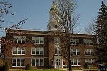
- St. Johnsbury Academy is a private high school founded by the Fairbanks family in 1842. The town of St. Johnsbury does not operate a public school for grades 9-12, but Vermont law requires towns not operating schools to pay tuition to other approved schools for students in the grades not provided, an amount up to the Average Announced Tuition for union schools.[22] A majority of St. Johnsbury secondary school students choose to be educated at St. Johnsbury Academy at the town's expense.
- St. Johnsbury Trade School opened in September 1918, offering the only four year vocational education in the area. The school's founders, Fairbanks, Morse and Company, wanted to provide young people with the opportunity to learn a trade while providing them a base for earning more money and high school courses.[23] After serving the community for over 50 years, the Trade School was closed, and the building then became the junior high. In 1981, it became the St. Johnsbury Middle School.[24] After consolidating the local school system, the old trade school became the site of the St. Johnsbury School serving students from k-8th grade.
- St. Johnsbury School now serves pre-kindergarten through 8th grade.
- Good Shepherd School is operated by St. John the Evangelist Roman Catholic Church and serves pre-school through 8th grade.
Government
Fire department
In 2010, the town employed ten firefighters. The department had an annual budget of $945,920. It has had a professional department since about 1910.[25]
Social services
Social services are provided in part by Northeast Kingdom Community Action located here and in other Northeast Kingdom sites.
Economy
Industry
- E.T. & H.K. Ide Company, a grain wholesaler founded in 1813, was the oldest continuously operating business in town when the family sold it in 2003. It is no longer operational.[26]
- Fairbanks Scales, precision machinery and manufacturing company still in business after more than 190 years, employs 160 workers.[27]
- Maple Grove Farms of Vermont was founded in 1915. It is the largest packer of pure maple syrup in the USA.[28][29]
Retail
Green Mountain Mall is a shopping mall north of downtown St. Johnsbury on U.S. Route 5.[30]
Medical
The Northeast Kingdom Human Services aids mental health needs. The Northeastern Vermont Regional Hospital is located in the town.
Culture

St. Johnsbury is the home of the Fairbanks Museum & Planetarium which opened in 1891 as a gift of Franklin Fairbanks, a businessman, naturalist and philanthropist, to the community. His donated collections remain northern New England’s most extensive natural history display, and the National Register-listed building is a splendid example of the Richardsonian Romanesque style. The Fairbanks Museum is well-known in Vermont for producing the "Eye on the Sky" weather forecast which is broadcast on Vermont Public Radio.
There has been an annual First Night community celebration of the arts on New Year's Eve since 1993.[31]
The town contains the only National Historic Landmark in the county, as well as the only one in the Northeast Kingdom - the St. Johnsbury Athenaeum. The town also contains 12 other places on the list of National Register of Historic Places, the most in Caledonia County or the Northeast Kingdom:
- Benoit Apartment House-74 Pearl Street (added June 6, 1994)
- Benoit Apartment House-76 Pearl Street (added June 6, 1994)
- Caleb H. Marshall House — 53 Summer St. (added September 16, 1994)
- Cote Apartment House — 16 Elm St. (added June 6, 1994)
- Franklin Fairbanks House — 30 Western Ave. (added October 27, 1980)
- Maple Street-Clarks Avenue Historic District — 17-49 Maple St., 4-34 Clarks Ave., 95 1⁄2-101 Main St., 4 and 6 Frost Ave. and 3 and 5 Idlewood Terr. (added June 5, 1994)
- Morency Paint Shop and Apartment Building — 73-77 Portland St. (added June 5, 1994)
- Railroad Street Historic District — roughly bounded north and south by Railroad St. and Canadian Pacific RR tracks (added July 25, 1974)
- Shearer and Corser Double House — 81-83 Summer St. (added September 16, 1994)
- St. Johnsbury Federal Fish Culture Station — 374 Emerson Falls Rd. (added April 18, 2005)
- St. Johnsbury Historic District — U.S. 5 and U.S. 2 (added May 17, 1980)
- St. Johnsbury Main Street Historic District — area along Main St. including intersecting streets (added June 28, 1975)
The town is mentioned in Hayden Carruth's classic poem "Regarding Chainsaws." [32] Carruth lived and farmed in that area of Vermont for many years.[33]

Media
The Caledonian-Record, a daily newspaper, has been published since 1837. Farming, the Journal of Northeast Agriculture is published locally.[34]
Infrastructure
Transportation
The following roads facilitate traffic: Interstate 91, Interstate 93, U.S. Route 2, U.S. Route 5 and Vermont Route 2B. Three exits from Interstate 91 serve the town. The northern terminus of Interstate 93 is at I-91 at the southern border of the town, and I-93 Exit 1, while just over the line in the town of Waterford, serves the eastern side of St. Johnsbury.
Notable people
See also
Footnotes
- 1 2 South of Saint Jay, Vermont retrieved July 29, 2008
- 1 2 3 "American FactFinder". United States Census Bureau. Retrieved 2008-01-31.
- ↑ "US Board on Geographic Names". United States Geological Survey. 2007-10-25. Retrieved 2008-01-31.
- ↑ Title 24, Part I, Chapter 1, §4, Vermont Statutes. Accessed 2007-11-01.
- ↑ "Find a County". National Association of Counties. Retrieved 2011-06-07.
- 1 2 "Geographic Identifiers: 2010 Demographic Profile Data (G001): St. Johnsbury town, Caledonia County, Vermont". U.S. Census Bureau, American Factfinder. Retrieved February 6, 2013.
- ↑
- ↑ Coolidge, Austin J.; John B. Mansfield (1859). A History and Description of New England. Boston, Massachusetts. pp. 908–909.
- ↑ Virtual Vermont -- St. Johnsbury, Vermont
- ↑ Gresser, Joseph (September 21, 2011). "Coffin shares Civil War stories with NVDA". the Chronicle. Barton, Vermont. p. 12.
- ↑ "The Vermont Bicentennial Calendar". The NEK Civil War Newsletter 2010. Brownington, Vermont. September 2010. p. 8.
- ↑ Oral history, conducted by Richard B. Verrone, Ph.D., The Vietnam Archive at Texas Tech University, 2006. Pp 27–8. Quote from former Caledonia reporter Barry Zorthian. Retrieved 2011-02-11.
- ↑ "US Gazetteer files: 2010, 2000, and 1990". United States Census Bureau. 2011-02-12. Retrieved 2011-04-23.
- ↑ St. Johnsbury: Connecticut River Byway
- ↑ Caledonia County, Vermont Local History and Genealogy
- ↑ "Geographic Identifiers: 2010 Demographic Profile Data (G001): St. Johnsbury CDP, Vermont". U.S. Census Bureau, American Factfinder. Retrieved February 6, 2013.
- ↑ U.S. Geological Survey St. Johnsbury, VT 7.5 by 15-minute quadrangle, 1983.
- ↑ "Vermont Snowfall and Snow Depth Extremes Table". National Climatic Data Center. National Oceanic and Atmospheric Administration. Retrieved February 9, 2013.
- ↑ "Climatography of the United States No. 20" (PDF). NOAA. Retrieved March 19, 2011.
- ↑ "St. Johnsbury town, Caledonia County, Vermont". Retrieved July 20, 2016.
- ↑ "U.S. Decennial Census". United States Census Bureau. Retrieved May 16, 2015.
- ↑ Programs & Services : School Finance
- ↑ "Vermonter.com".
- ↑ http://www.stjsd.org
- ↑ Rathke, Lisa (18 September 2010). "St. Johnsbury debates on-call versus full-time firefighters". Burlington, Vermont: Burlington Free Press. pp. 1B.
- ↑ Bio of Robert Ide retrieved July 8, 2008
- ↑ Dodge, Sylvia (1996). "St J loses some, but keeps its eyes level". Vermont Business Magazine.
- ↑
- ↑
- ↑ Green Mountain Mall
- ↑
- ↑ http://www.poetryfoundation.org/features/audioitem/689
- ↑ http://magazine.uchicago.edu/0504/features/carruth.shtml
- ↑ Dunbar, Bethany M. (24 February 2010). "Editor travels to Germany to learn about renewable energy". Barton, Vermont: the Chronicle. pp. 1B.
References
- Claire Dunne Johnson (1996). Images of America: St. Johnsbury. Arcadia Publishing. ISBN 0-7524-0260-9.
- St. Johnsbury history
External links
| Wikimedia Commons has media related to St. Johnsbury, Vermont. |
- Town of St. Johnsbury official website
- St. Johnsbury Community Archives
- Northeast Kingdom Chamber of Commerce
- 1911 Encyclopedia -- St. Johnsbury, Vermont
Municipalities and communities of Caledonia County, Vermont, United States | ||
|---|---|---|
| Towns |  | |
| Villages | ||
| CDPs | ||
| Other community | ||
Montpelier (capital) | |
| Regions | |
| Counties | |
| Cities | |
| Towns (pop. >5000) | |
| Festivals | |
| Topics |
|
| Society |
|