St. Clair Township, Columbiana County, Ohio
| St. Clair Township, Columbiana County, Ohio | |
|---|---|
| Township | |
|
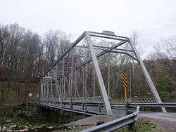
Grimms Bridge (1884) crosses the Little Beaver Creek east of Calcutta | |
 Location of St. Clair Township in Columbiana County | |
| Coordinates: 40°40′31″N 80°34′57″W / 40.67528°N 80.58250°WCoordinates: 40°40′31″N 80°34′57″W / 40.67528°N 80.58250°W | |
| Country | United States |
| State | Ohio |
| County | Columbiana |
| Area | |
| • Total | 29.6 sq mi (76.7 km2) |
| • Land | 29.5 sq mi (76.3 km2) |
| • Water | 0.2 sq mi (0.4 km2) |
| Elevation[1] | 1,148 ft (350 m) |
| Population (2010) | |
| • Total | 7,957 |
| • Density | 270/sq mi (104.3/km2) |
| Time zone | Eastern (EST) (UTC-5) |
| • Summer (DST) | EDT (UTC-4) |
| FIPS code | 39-69512[2] |
| GNIS feature ID | 1085901[1] |
St. Clair Township is one of the eighteen townships of Columbiana County, Ohio, United States. As of the 2010 census the population was 7,957.[3]
Geography
Located in the southeastern part of the county, it borders the following townships and borough:
- Middleton Township - north
- Ohioville, Pennsylvania - east
- Liverpool Township - south
- Madison Township - west
- Elkrun Township - northwest corner
No municipalities are located in St. Clair Township, although the census-designated places of Calcutta and Glenmoor are located in the center and southwest of the township respectively, and the unincorporated community of Fredericktown lies in the township's northeast.
Name and history
Statewide, the only other St. Clair Township is located in Butler County.
The township was among the first organized in the county in 1803.[4]
Government
The township is governed by a three-member board of trustees, who are elected in November of odd-numbered years to a four-year term beginning on the following January 1. Two are elected in the year after the presidential election and one is elected in the year before it. There is also an elected township fiscal officer,[5] who serves a four-year term beginning on April 1 of the year after the election, which is held in November of the year before the presidential election. Vacancies in the fiscal officership or on the board of trustees are filled by the remaining trustees.
References
- 1 2 "US Board on Geographic Names". United States Geological Survey. 2007-10-25. Retrieved 2008-01-31.
- ↑ "American FactFinder". United States Census Bureau. Retrieved 2008-01-31.
- ↑ "Geographic Identifiers: 2010 Demographic Profile Data (G001): St. Clair township, Columbiana County, Ohio". U.S. Census Bureau, American Factfinder. Retrieved January 28, 2015.
- ↑ Cranmer, Gibson Lamb (1891). History of the upper Ohio Valley. 2. Madison, Wisconsin: Brant & Fuller. p. 22.
- ↑ §503.24, §505.01, and §507.01 of the Ohio Revised Code. Accessed 4/30/2009.
External links
Municipalities and communities of Columbiana County, Ohio, United States | ||
|---|---|---|
| Cities |  | |
| Villages | ||
| Townships | ||
| CDPs | ||
| Unincorporated communities |
| |
| Ghost town | ||
| Footnotes | ‡This populated place also has portions in an adjacent county or counties | |