Springfield Center, New York
| Springfield Center, New York | |
|---|---|
| hamlet | |
 Springfield Center, New York | |
| Coordinates: 42°49′44″N 74°52′36″W / 42.82889°N 74.87667°WCoordinates: 42°49′44″N 74°52′36″W / 42.82889°N 74.87667°W | |
| Country | United States |
| State | New York |
| County | Otsego |
| Elevation | 1,260 ft (380 m) |
| Time zone | Eastern (EST) (UTC-5) |
| • Summer (DST) | EDT (UTC-4) |
| ZIP code | 13468 |
| Area code(s) | 607 |
| GNIS feature ID | 966098[1] |
Springfield Center is a hamlet in the town of Springfield, Otsego County, New York, United States. Springfield Center is located on New York State Route 80 9.2 miles (14.8 km) north-northeast of Cooperstown. Springfield Center has a post office with ZIP code 13468, which opened on July 16, 1850.[2][3]
The Springfield Center Elementary School was listed on the National Register of Historic Places in 2011 and St. Mary's Episcopal Church Complex in 2015.[4][5]
References
- ↑ "Springfield Center". Geographic Names Information System. United States Geological Survey.
- ↑ United States Postal Service (2012). "USPS - Look Up a ZIP Code". Retrieved 2012-02-15.
- ↑ "Postmaster Finder - Post Offices by ZIP Code". United States Postal Service. Retrieved June 1, 2013.
- ↑ "National Register of Historic Places". Weekly List of Actions Taken on Properties: 8/22/11 through 8/26/11. National Park Service. 2011-09-02.
- ↑ "National Register of Historic Places". Weekly List of Actions Taken on Properties: 3/16/15 through 3/20/15. National Park Service. 2015-03-27.
Municipalities and communities of Otsego County, New York, United States | ||
|---|---|---|
| City | 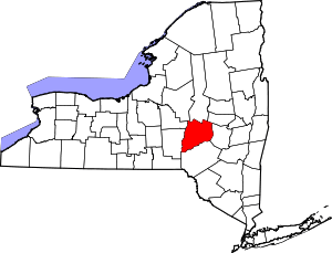 | |
| Towns | ||
| Villages | ||
| CDPs | ||
| Other hamlets | ||
| Footnotes | ‡This populated place also has portions in an adjacent county or counties | |
This article is issued from Wikipedia - version of the 9/12/2016. The text is available under the Creative Commons Attribution/Share Alike but additional terms may apply for the media files.