Southwest Penang Island District
| Southwest Penang Island District | |||
|---|---|---|---|
| District of Malaysia | |||
| Other transcription(s) | |||
| • Malay | Daerah Barat Daya Pulau Pinang | ||
| • Chinese | 西南县 | ||
|
Balik Pulau, a town at southwestern Penang Island, is the seat of the district. | |||
| |||
|
Motto: Leading We Serve Memimpin Sambil Berkhidmat | |||
 Location of the Southwest Penang Island District within the state of Penang. | |||
| Country |
| ||
| State |
| ||
| Seat | Balik Pulau | ||
| Largest Town | Bayan Lepas | ||
| Government | |||
| • Local Government | Penang Island City Council | ||
| • Mayor of Penang Island | Patahiyah binti Ismail | ||
| Area | |||
| • Total | 176 km2 (68 sq mi) | ||
| Population (2012) | |||
| • Total | 209,100[1] | ||
| Time zone | MST (UTC+8) | ||
| • Summer (DST) | Not observed (UTC) | ||
| Postal code | 110xx, 119xx | ||
| National calling code | +604 | ||
| License plate prefix | P | ||
| Website | http://www.mbpp.gov.my | ||

.svg.png)
The Southwest Penang Island District is a district within the state of Penang, Malaysia. It covers southern and western Penang Island, and is larger in size than the other district on the island, the Northeast Penang Island District.[2] Together with mainland Seberang Perai and southern Kedah, the district forms part of the Greater Penang Conurbation, the second most populous metropolitan area in Malaysia.
Although the district capital is Balik Pulau, the largest town is in fact Bayan Lepas, where Penang's Free Industrial Zone is located. Created in the 1970s by the then Chief Minister of Penang, Lim Chong Eu, the Bayan Lepas Free Industrial Zone has propelled Penang Island to become the 'Silicon Valley of the East'.[3][4] This also sparked the development of Bayan Lepas and eventually led to the urbanisation of the entire eastern seaboard of Penang Island.
In addition, the Penang International Airport, the major airport in northern Malaysia, is located within Bayan Lepas. Completed in 1935, the airport connects the northern region of Malaysia with other regional cities, such as Kuala Lumpur, Singapore, Bangkok, Hong Kong and Taipei.
Unlike the urbanised Northeast Penang Island District, much of the Southwest Penang Island District remain forested. Some of Penang's most famous agricultural produce are harvested here, including durians and nutmegs.[5][6] Agricultural and natural tourist attractions have been established all over the district. For instance, the Penang Butterfly Farm and the Tropical Spice Garden at Teluk Bahang, near the northwestern tip of Penang Island.[7][8] The adjacent Penang National Park also covers some of the more pristine beaches on Penang Island.
The Southwest Penang Island District borders the Northeast Penang Island District, which includes George Town, the capital city of Penang. Both districts are administered by the Penang Island City Council.
History
Soon after Captain Francis Light had landed in what is now George Town in 1786, agricultural plantations were established around Balik Pulau at the southwestern part of Penang Island. The British East India Company, which had commissioned Light to obtain Penang Island, intended to make the island a centre of spice production in order to break the Dutch monopoly of the spice trade in Southeast Asia.[9]
Nutmegs and cloves were introduced to Balik Pulau in 1794.[10] During the first half of the 19th century, the clove and nutmeg farms of Balik Pulau attracted Malay refugees fleeing the Siamese invasion of Kedah and Chinese immigrants.[11][12]
Meanwhile, Bayan Lepas, at the southeastern part of Penang Island, began to emerge in the late 19th century. Folklore has it that the name Bayan Lepas (Malay: escaped parrot) was derived from a lost parakeet belonging to a rich family who had arrived from Sumatra.[13]
A district office was formed for southwestern Penang Island in 1880 by an employee of the British.[14] The office later evolved into the District Office of the Southwest Penang Island District.
A civilian airfield was completed in Bayan Lepas in 1935, the first of its kind in the Malay Peninsula. This would become the Penang International Airport, one of the busiest airports in Malaysia.
However, Bayan Lepas, which was originally an agricultural town, only truly transformed beginning in the 1970s. To arrest Penang's economic slump which was caused by the Malaysian federal government's revocation of George Town's free port status, the then Chief Minister of Penang, Lim Chong Eu, ordered the establishment of the Free Industrial Zone.[15][16] Pioneer tax status was offered to multi-national electronic firms setting up factories and assembly plants. Complemented by low-cost labour, the Bayan Lepas Free Industrial Zone managed to pull Penang out from its economic downtuen and grew to become the 'Silicon Valley of the East'.[3]
Geography

The Southwest Penang Island District covers southern and western Penang Island, as well as parts of the island's central hill ranges. Under the district are the following towns and residential areas.
Towns

Residential Areas and Villages
The district comprises 16.8% of Penang's total land mass.[2]
Governance
Local Government
Although districts in Malaysia were created for the purpose of land administration and revenue, in practice, it is the local council that manages the provision of basic amenities and maintenance of urban infrastructure.
The Penang Island City Council, an agency under the Penang state government, is the local authority in charge of the whole Penang Island. With a history dating back to 1800, it is the oldest local authority in Malaysia and the successor to the country's first city council - the George Town City Council. Its headquarters is the City Hall in George Town, within the Northeast Penang Island District.
The Mayor of Penang Island is appointed by the Penang state government every two years.[17][18] The current Mayor of Penang Island is Patahiyah binti Ismail.
Electoral Constituencies
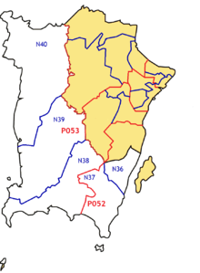
| Federal Constituency | Party | Member of Parliament | State Constituency | Party | State Assemblyman |
|---|---|---|---|---|---|
| Bayan Baru (P052) | PKR | Sim Tze Tzin | Pantai Jerejak (N36) | PKR | Mohd Rashid Hasnon |
| Batu Maung (N37) | PKR | Abdul Malik bin Abdul Kassim | |||
| Balik Pulau (P053) | BN | Hilmi Yahaya | Bayan Lepas (N38) | BN | Nordin bin Ahmad |
| Pulau Betong (N39) | BN | Muhammad Farid Saad | |||
| Telok Bahang (N40) | BN | Shah Haedan bin Ayoob Hussain Shah |
Education
Most schools in the district are national schools, which are run under Malaysia's Ministry of Education. In addition, a few international schools, such as the Prince of Wales International School and the Straits International School, have been set up in Bayan Lepas and Balik Pulau.[19][20]
The Penang State Library operates a branch in Balik Pulau.[21]
Health Care
The Balik Pulau Hospital is the main hospital within the Southwest Penang Island District. It complements the Penang General Hospital in providing healthcare to the citizens on Penang Island.
Pantai Mutiara Hospital in Bayan Lepas is the sole private hospital in the district.[22]
Transportation


Land
The Southwest Penang Island District is connected to the rest of Peninsular Malaysia via the Second Penang Bridge, which runs between Batu Maung at the southeastern tip of Penang Island and Batu Kawan on the mainland. The bridge, with a length of 24 km, is now the longest in Southeast Asia.
Federal Route 6 is a winding trunk road that serves as the pan-island road, forming a circular loop along the length of Penang Island's coastline. The road links Bayan Lepas, Balik Pulau and Teluk Bahang with George Town in the Northeast Penang Island District.
Public transportation throughout Penang Island is provided by Rapid Penang, which has public bus services between George Town, Bayan Lepas (including the Penang International Airport), Balik Pulau and Teluk Bahang.
Air

The Penang International Airport in Bayan Lepas serves as the major airport within the northern region of Peninsular Malaysia. Completed in 1935, it is also the oldest civilian airport in the nation.
Today, it is one of the busiest airports in Malaysia in terms of cargo tonnage and passenger traffic, highlighting the role Penang Island plays as a tourist destination and a major manufacturing hub. The airport's proximity to the Bayan Lepas Free Industrial Zone allows for the easy transportation of goods to and from the factories in Bayan Lepas. In addition, it connects Penang with several major regional cities, including Kuala Lumpur, Singapore, Bangkok, Jakarta, Hong Kong, Guangzhou, Taipei, Ho Chi Minh City and Yangon.
Tourist Attractions

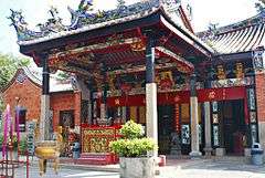
The Snake Temple in Bayan Lepas is said to be the only Chinese temple to be inhabited by snakes. Built in the 1850s by a Buddhist monk, it has attracted varieties of pit vipers, which are believed to be rendered harmless by the incense. The temple is also a focal point of the annual Chinese New Year celebrations, during which a flame-watching ceremony is held to predict the fortunes of the next 12 months.[23]
The Penang War Museum is located at the southeastern tip of Penang Island. The sprawling complex was originally Fort Batu Maung, built by the British Army in the 1930s to defend Penang Island against amphibious invasion.[24][25] However, during World War II, the British Army abandoned the fort to the Imperial Japanese Army without a fight. Neglected after the war, the fortress was converted into a museum in 2002, and features bunkers, tunnels and other military structures.
Balik Pulau is famous for its agricultural plantations, which are rarely found elsewhere on Penang Island. In recent years, agricultural tourism is booming in Balik Pulau, as tourists from other states and abroad flock to the town to sample fresh durians and nutmegs.[26][27][28][29]
The Penang National Park, covering 2,562 hectares of rainforests, swamps and beaches at the northwestern tip of Penang Island, is the smallest gazetted national park in Malaysia. Within the park are some of the most pristine beaches on Penang Island, such as Kerachut Beach and Monkey Beach. Turtles can also be occasionally spotted laying eggs along these beaches.[30] A canopy walk also allows visitors an impressive view of the lush rainforest underneath.
In addition, the adjacent town of Teluk Bahang is home to unique agricultural attractions, such as the Penang Butterfly Farm, Tropical Spice Garden and Tropical Fruit Farm.[7][8][31]
See also
| Wikimedia Commons has media related to Southwest Penang Island. |
References
- ↑ http://penanginstitute.org/v3/resources/data-centre/122-population
- 1 2 "An analysis of Penang". Penang Monthly. 2014-08-22. Retrieved 2016-11-01.
- 1 2 "History of Industrial Development Strategies in Penang since Independence: A Study of the SMEs". Universiti Kebangsaan Malaysia. http://www.ccsenet.org/journal/index.php/ass/article/viewFile/27013/16497.
- ↑ "Fullcontact: About Malaysia". www.fullcontact.nl. Retrieved 16 October 2016.
- ↑ "BERNAMA - Nutmeg Production In Balik Pulau, A Four-generation Family Business". www.bernama.com. Retrieved 2016-11-01.
- ↑ "Penang Durians, A Comprehensive Guide". Retrieved 2016-11-01.
- 1 2 "Penang Butterfly Farm – The World's 1st Tropical Live Butterfly Sanctuary, Butterfly, Insects, Nature, Lizards, Tarantullas, Tour, Penang, Malaysia". Butterfly-insect.com. Retrieved 3 January 2011.
- 1 2 "Home - Tropical Spice Garden". Tropical Spice Garden. Retrieved 2016-10-21.
- ↑ Souza, George Bryan (2014). Hinterlands and Commodities: Place, Space, Time and the Political Economic Development of Asia over the Long Eighteenth Century. BRILL. ISBN 9789004283909.
- ↑ "Balik Pulau, Penang / Pulau Pinang". Retrieved 2016-11-01.
- ↑ "Balik Pulau, Penang / Pulau Pinang". Retrieved 2016-10-20.
- ↑ Administrator. "History Of Balik Pulau". www.istaybalikpulau.com. Retrieved 2016-10-20.
- ↑ "Bayan Lepas, Penang / Pulau Pinang". Retrieved 2016-11-01.
- ↑ "Pejabat Daerah dan Tanah Daerah Barat Daya Pulau Pinang".
- ↑ "Transformation of Bayan Lepas into free trade area does not diminish its attractions - Community | The Star Online". www.thestar.com.my. Retrieved 2016-10-20.
- ↑ http://profile.nus.edu.sg/fass/socgohd/trans_2.1.pdf
- ↑ "Newbies pledge to give their best - Community | The Star Online". www.thestar.com.my. Retrieved 15 October 2016.
- ↑ "Organisation Chart". Official Portal of Penang Island City Council (MBPP). 9 October 2015. Retrieved 15 October 2016.
- ↑ Bhd, Tradsure Com Sdn. "Home | Straits International School Penang". sisgroup.edu.my. Retrieved 2016-11-01.
- ↑ "Prince of Wales Island International School - Penang, Malaysia". POWIIS. Retrieved 2016-11-01.
- ↑ "Penang Library Corporation".
- ↑ "https://www.pantai.com.my/penang". www.pantai.com.my. Retrieved 2016-11-02. External link in
|title=(help) - ↑ "First four months look good, snake temple deity says - Nation | The Star Online". www.thestar.com.my. Retrieved 2016-11-02.
- ↑ "Penang War Museum, Batu Maung, Penang / Pulau Pinang". Retrieved 2016-11-02.
- ↑ "Penang War Museum Batu Maung - Opening Hours, Entrance Fee". Travel-Penang-Malaysia.com. Retrieved 2016-11-02.
- ↑ "myPenang - A Day in Balik Pulau". www.mypenang.gov.my. Retrieved 2016-11-02.
- ↑ II, Administrator. "The Back of the Island - Balik Pulau". www.visitpenang.gov.my. Retrieved 2016-11-02.
- ↑ "From jungle durians to a tour, our pick of farms to visit in Balik Pulau". 2015-06-28. Retrieved 2016-10-21.
- ↑ jalmsab@st (2015-07-13). "Forget D24 and Maoshan, try kampong durians in Penang". The Straits Times. Retrieved 2016-10-21.
- ↑ "Penang National Park | Penang for Budget Travelers". Penang-traveltips.com. Retrieved 3 January 2011.
- ↑ "Welcome to Tropical Fruit Farm". tropicalfruitfarm.com.my. Retrieved 2016-10-21.