South Puyallup River Bridge
|
South Puyallup River Bridge | |
 | |
 | |
| Nearest city | Nisqually Entrance, Washington |
|---|---|
| Coordinates | 46°48′29″N 121°53′26″W / 46.80806°N 121.89056°WCoordinates: 46°48′29″N 121°53′26″W / 46.80806°N 121.89056°W |
| Area | less than one acre |
| Built | 1931 |
| Architectural style | Rustic style |
| MPS | Mt. Rainier National Park MPS |
| NRHP Reference # | [1] |
| Added to NRHP | March 13, 1991 |
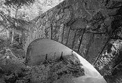
The South Puyallup River Bridge was built in 1930-31 in Mount Rainier National Park as part of the West Side Road project, planned to link the park's Nisqually and Carbon River entrances. The stone-faced reinforced concrete bridge was designed by the National Park Service and the Bureau of Public Roads. It spans 42 feet (13 m) and is almost 35 feet (11 m) wide, carrying two lanes of traffic.[2]
The bridge was placed on the National Register of Historic Places on March 13, 1991. It is part of the Mount Rainier National Historic Landmark District, which encompasses the entire park and which recognizes the park's inventory of Park Service-designed rustic architecture.[1]
References
- 1 2 National Park Service (2009-03-13). "National Register Information System". National Register of Historic Places. National Park Service.
- ↑ Fitzsimmons, Gray (September 12, 1992). "Pacific Northwest Regional Office Inventory: South Puyallup River Bridge" (PDF). National Park Service. Retrieved March 21, 2011.
External links
- Historic American Engineering Record (HAER) No. WA-52, "South Puyallup River Bridge, Spanning South Puyallup River at West Side Road, Longmire vicinity, Pierce County, WA"
| Topics | |
|---|---|
| Lists by states |
|
| Lists by insular areas | |
| Lists by associated states | |
| Other areas | |
| |
This article is issued from Wikipedia - version of the 11/29/2016. The text is available under the Creative Commons Attribution/Share Alike but additional terms may apply for the media files.