South East Busway
| South East Busway | |||||||||||||||||||||||||||||||||||||||||||||||||||||||||||||||||||||||||||||||||||||||||||||||||||||||||||||||||||||||||||||||||||||||||||||||||||||||||||||||||||||||||||||||||||||||||||||||||||||||||||||||||||||||||||||||||||||||||||||||||||||||||||||||||||||||||||||||||||||||||||
|---|---|---|---|---|---|---|---|---|---|---|---|---|---|---|---|---|---|---|---|---|---|---|---|---|---|---|---|---|---|---|---|---|---|---|---|---|---|---|---|---|---|---|---|---|---|---|---|---|---|---|---|---|---|---|---|---|---|---|---|---|---|---|---|---|---|---|---|---|---|---|---|---|---|---|---|---|---|---|---|---|---|---|---|---|---|---|---|---|---|---|---|---|---|---|---|---|---|---|---|---|---|---|---|---|---|---|---|---|---|---|---|---|---|---|---|---|---|---|---|---|---|---|---|---|---|---|---|---|---|---|---|---|---|---|---|---|---|---|---|---|---|---|---|---|---|---|---|---|---|---|---|---|---|---|---|---|---|---|---|---|---|---|---|---|---|---|---|---|---|---|---|---|---|---|---|---|---|---|---|---|---|---|---|---|---|---|---|---|---|---|---|---|---|---|---|---|---|---|---|---|---|---|---|---|---|---|---|---|---|---|---|---|---|---|---|---|---|---|---|---|---|---|---|---|---|---|---|---|---|---|---|---|---|---|---|---|---|---|---|---|---|---|---|---|---|---|---|---|---|---|---|---|---|---|---|---|---|---|---|---|---|---|---|---|---|---|---|---|---|---|---|---|---|---|---|---|---|---|---|---|---|---|---|
| Overview | |||||||||||||||||||||||||||||||||||||||||||||||||||||||||||||||||||||||||||||||||||||||||||||||||||||||||||||||||||||||||||||||||||||||||||||||||||||||||||||||||||||||||||||||||||||||||||||||||||||||||||||||||||||||||||||||||||||||||||||||||||||||||||||||||||||||||||||||||||||||||||
| System | TransLink | ||||||||||||||||||||||||||||||||||||||||||||||||||||||||||||||||||||||||||||||||||||||||||||||||||||||||||||||||||||||||||||||||||||||||||||||||||||||||||||||||||||||||||||||||||||||||||||||||||||||||||||||||||||||||||||||||||||||||||||||||||||||||||||||||||||||||||||||||||||||||||
| Status | In service | ||||||||||||||||||||||||||||||||||||||||||||||||||||||||||||||||||||||||||||||||||||||||||||||||||||||||||||||||||||||||||||||||||||||||||||||||||||||||||||||||||||||||||||||||||||||||||||||||||||||||||||||||||||||||||||||||||||||||||||||||||||||||||||||||||||||||||||||||||||||||||
| Began service | 13 September 2000 | ||||||||||||||||||||||||||||||||||||||||||||||||||||||||||||||||||||||||||||||||||||||||||||||||||||||||||||||||||||||||||||||||||||||||||||||||||||||||||||||||||||||||||||||||||||||||||||||||||||||||||||||||||||||||||||||||||||||||||||||||||||||||||||||||||||||||||||||||||||||||||
| Route | |||||||||||||||||||||||||||||||||||||||||||||||||||||||||||||||||||||||||||||||||||||||||||||||||||||||||||||||||||||||||||||||||||||||||||||||||||||||||||||||||||||||||||||||||||||||||||||||||||||||||||||||||||||||||||||||||||||||||||||||||||||||||||||||||||||||||||||||||||||||||||
| Start | Adelaide Street bus mall | ||||||||||||||||||||||||||||||||||||||||||||||||||||||||||||||||||||||||||||||||||||||||||||||||||||||||||||||||||||||||||||||||||||||||||||||||||||||||||||||||||||||||||||||||||||||||||||||||||||||||||||||||||||||||||||||||||||||||||||||||||||||||||||||||||||||||||||||||||||||||||
| Via | Pacific Motorway | ||||||||||||||||||||||||||||||||||||||||||||||||||||||||||||||||||||||||||||||||||||||||||||||||||||||||||||||||||||||||||||||||||||||||||||||||||||||||||||||||||||||||||||||||||||||||||||||||||||||||||||||||||||||||||||||||||||||||||||||||||||||||||||||||||||||||||||||||||||||||||
| End | Springwood bus station | ||||||||||||||||||||||||||||||||||||||||||||||||||||||||||||||||||||||||||||||||||||||||||||||||||||||||||||||||||||||||||||||||||||||||||||||||||||||||||||||||||||||||||||||||||||||||||||||||||||||||||||||||||||||||||||||||||||||||||||||||||||||||||||||||||||||||||||||||||||||||||
| Length | 13.2 km (8.2 mi) | ||||||||||||||||||||||||||||||||||||||||||||||||||||||||||||||||||||||||||||||||||||||||||||||||||||||||||||||||||||||||||||||||||||||||||||||||||||||||||||||||||||||||||||||||||||||||||||||||||||||||||||||||||||||||||||||||||||||||||||||||||||||||||||||||||||||||||||||||||||||||||
| Stations | 13 | ||||||||||||||||||||||||||||||||||||||||||||||||||||||||||||||||||||||||||||||||||||||||||||||||||||||||||||||||||||||||||||||||||||||||||||||||||||||||||||||||||||||||||||||||||||||||||||||||||||||||||||||||||||||||||||||||||||||||||||||||||||||||||||||||||||||||||||||||||||||||||
| |||||||||||||||||||||||||||||||||||||||||||||||||||||||||||||||||||||||||||||||||||||||||||||||||||||||||||||||||||||||||||||||||||||||||||||||||||||||||||||||||||||||||||||||||||||||||||||||||||||||||||||||||||||||||||||||||||||||||||||||||||||||||||||||||||||||||||||||||||||||||||
The South East Busway is a grade separated bus-only corridor running south from the Brisbane CBD to Eight Mile Plains, in South East Queensland. Service providers using the Busway operate under the TransLink system. The Busway was completed to Woolloongabba in September 2000 and to Eight Mile Plains in April 2001.[1][2] An extension of the Busway to School Road at Rochedale was completed in 2014.[3]
History
Busways were considered as one of the options when the Queensland Government developed the 25 year Integrated Regional Transport Plan.[4][5][6] Other methods such as light and heavy rail were also considered. It was recommended that a 75 km (47 mi) network of busway corridors to complement the existing heavy rail network would suit best.
Busways would allow buses to serve low-density communities and bypass peak hour congestion. Busway stations could be developed at key nodes to serve major activity centres and combining different routes would create high frequency services.
In 1995, plans for a network of five busway corridors were conceived, linking with the rail network to improve public transport connectivity across the city. The busways would improve the operation of the bus fleet, reducing maintenance and running costs and maximizing the effectiveness of the region's investment in buses.
In August 1996, the Queensland Government approved the South East Transit Project to manage the construction of both the northern section of the Pacific Motorway between Mount Gravatt and Logan City and a dedicated 2-lane, 2-way road for buses between Brisbane CBD and Eight Mile Plains.
The first section of busway between the CBD and Woolloongabba was opened to services on 13 September 2000 to coincide with the first match in the 2000 Olympic Games Football Tournament in Brisbane. The second 13.2 km (8.2 mi) section of busway between Woolloongabba and Eight Mile Plains opened on 30 April 2001.
Route
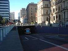
The Busway is connected at its southern end to Springwood bus station via the Pacific Motorway (M1).[7] The route then passes under the Gateway Motorway (M1) and runs parallel to the Pacific Motorway (M3) between Eight Mile Plains and Woolloongabba stations. At the Mater Hill station, the busway passes under Stanley Street and runs parallel to the rail lines from South Bank station to the Cultural Centre station. Finally, the northern end of the Busway crosses from the Cultural Centre station at South Brisbane across the Victoria Bridge to enter the Brisbane central business district to connect with the Queen Street bus station and Adelaide Street bus mall.
Future extensions
Currently, the Pacific Motorway enables better connections between the South East Busway, Springwood and Loganholme with additional stations in between at Underwood and Paradise Road, for the benefit of Logan City Bus Service passengers travelling to the city.
As part of the Main Roads Pacific Motorway Transit Project,[8] plans have been made to extend the South-East Busway as far as Springwood bus station including construction of the proposed Rochedale busway station.[9]
Construction of the Eight Mile Plains to Rochedale extension to the Busway commenced in late 2012 and was completed in March 2014. The extension was funded by the Queensland Government (A$36m) and formed part of the Federal Government's Gateway Upgrade South (GUS) project.[3] The busway extension passes under the Gateway Motorway and terminates at School Road, Rochedale. No new busway stations were added by this extension.
Passenger information
Real Time Passenger Information is displayed at each station, with fixed LED signs suspended above each platform. These signs present four lines of real-time estimated bus departure times, with data provided by Brisbane City Council's RAPID system.
See also
References
- ↑ "Busways". Queensland Government, Department of Transport and Main Roads. Retrieved 11 March 2011.
- ↑ Shunter, Loose (30 October 2010). "A decade of Australian Public Transport Projects". TransportTextbook. Retrieved 11 March 2011.
- 1 2 "Gateway Upgrade South (GUS) project and South East Busway extension". Queensland Government, Department of Transport and Main Roads. Retrieved 1 January 2015.
- ↑ "Integrated Regional Transport Plan". Queensland Government, Department of Transport and Main Roads. Retrieved 11 March 2011.
- ↑ "South East Busway, Brisbane". Road Traffic Technology. Retrieved 11 March 2011.
- ↑ "Integrated Regional Transport Plan (Part 1)" (PDF). Queensland Government, Department of Transport and Main Roads. p. 29 (PDF page 46). Retrieved 11 March 2011.
- ↑ "South East Transit Project". The Harrison Group. 2007. Retrieved 11 March 2011.
- ↑ Main Roads Pacific Motorway Transit Project
- ↑ Translink South East Busway Extension
External links
| Wikimedia Commons has media related to South East Busway. |
Coordinates: 27°30′29″S 153°02′20.4″E / 27.50806°S 153.039000°E