South Dakota Highway 115
| ||||
|---|---|---|---|---|
|
Route of SD 115 (in red) | ||||
| Route information | ||||
| Defined by SDCL §31-4-191 | ||||
| Maintained by SDDOT | ||||
| Length: | 40 mi (60 km) | |||
| Existed: | 1980 – present | |||
| Major junctions | ||||
| South end: |
| |||
| North end: |
| |||
| Location | ||||
| Counties: | Lincoln, Minnehaha | |||
| Highway system | ||||
| ||||

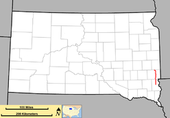
South Dakota Highway 115 (SD 115) was created from the routing of US 77, "Old 77", when its alignment was moved west to become Interstate 29 around 1980 and SD 15's route from US 18 to Sioux Falls. SD 115 routes from its intersection with US 18 about 13 miles (21 km) south of Sioux Falls to Interstate 29 three miles west of Dell Rapids. It is about 40.5 miles (65.2 km) in length.
SD 115 was designated a POW/MIA Memorial Highway in 2000. The segment south of Sioux Falls to US 18 was originally designated part of the Custer Battlefield Highway when it was designated SD 15.
Route description
South Dakota Highway 115 begins at an intersection with US 18 west of Canton and heads due north through rural Lincoln County. The highway runs just west of Worthing and about a mile west of Harrisburg, South Dakota. Three miles north of the Harrisburg intersection, SD 115 intersects 85th Street and enters Sioux Falls from the south. It runs along Minnesota Avenue in the southern portion of Sioux Falls and enters Minnehaha County upon crossing 57th Street. Just south of 41st Street, SD 115 meets Interstate 229. SD 115 travels farther north through the downtown section of Sioux Falls, meeting SD 42 eastbound at 11th Street and westbound at 10th Street. North of downtown Sioux Falls, the route turns east on Benson Road, then north again on Cliff Avenue. It then meets Interstate 90 just before exiting Sioux Falls.[1]
North of Sioux Falls, SD 115 travels through rural, sparsely populated areas of Minnehaha County. It passes through Renner and east of Baltic before entering Dell Rapids. In Dell Rapids, the highway turns west at 4th Street and travels about three miles west to its terminus at Interstate 29.[1]
Major intersections
| County | Location | mi | km | Destinations | Notes |
|---|---|---|---|---|---|
| Lincoln | | 0.000 | 0.000 | ||
| Minnehaha | Sioux Falls | I-229 exit 3. | |||
| I-90 exit 399. | |||||
| | I-29 exit 98. | ||||
| 1.000 mi = 1.609 km; 1.000 km = 0.621 mi | |||||
References
- 1 2 "Google Maps Overview of SD 115". Retrieved October 31, 2012.