South Bačka District
| Južnobački okrug Јужнобачки округ | |
|---|---|
| District of Serbia | |
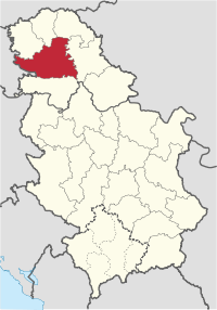 Location of South Bačka District in Serbia | |
| Country |
|
| Capital | Novi Sad |
| Government | |
| • Commissioner | Obrad Milošević[1] |
| Area | |
| • Total | 4,016 km2 (1,551 sq mi) |
| Population (2011 census) | |
| • Total | 615 371 |
| • Density | 151.3/km2 (392/sq mi) |
| Municipalities | 11 and 1 city |
| Settlements | 77 |
| - Cities and towns | 16 |
| - Villages | 61 |
South Bačka District (Serbian: Јужнобачки округ, Južnobački okrug) is a northern district (okrug) of Serbia. It lies in the southern part of Bačka and northern part of Syrmia, in the autonomous province of Vojvodina. It has a population of 615,371. The main city and seat of the district is Novi Sad, which is also the capital and the largest city of the Autonomous Province of Vojvodina.
Name
In Serbian, the district is known as Južnobački okrug (Јужнобачки округ), or in official documents, the name may also be spellt Južno-Bački okrug (Јужно-Бачки округ). In Croatian it is known as Južnobački okrug; in Hungarian as Dél-bácskai körzet; in Slovak as Juhobáčsky okres; in Romanian as Districtul Bacica de Sud and in Rusyn, a Cyrillic-based script: Јужнобачки округ.
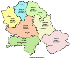
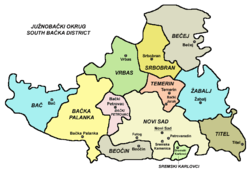
Municipalities
District is divided into 11 municipalities and City of Novi Sad, which is divided into two urban municipalities:
- Srbobran
- Bač
- Bečej (Hungarian: Óbecse)
- Vrbas
- Bačka Palanka
- Bački Petrovac (Slovak: Báčsky Petrovec)
- Žabalj
- Titel
- Temerin
- Beočin
- Sremski Karlovci
City of Novi Sad is divided into municipalities of:
Note: for municipalities with Hungarian and Slovak relative or absolute majority names are also given in these languages.
Settlements
There are 76 towns and villages, and 1 city in South Bačka. The largest settlements in the district are:[2]
| Settlement | Population (2002 Census) |
Population (2011 Census)[3] |
|---|---|---|
| Novi Sad | 191,405 | 250,439 |
| Bačka Palanka | 29,449 | 28,239 |
| Vrbas | 25,907 | 24,112 |
| Bečej | 25,774 | 23,895 |
| Temerin | 19,216 | 19,661 |
| Futog | 18,582 | 18,641 |
| Veternik | 18,626 | 17,454 |
| Petrovaradin | 13,973 | 14,810 |
| Sremska Kamenica | 11,205 | 12,273 |
| Srbobran | 13,091 | 12,009 |
| Kać | 11,166 | 11,740 |
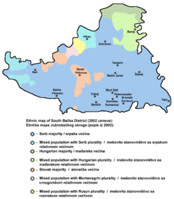
Ethnic groups
| Ethnic group |
census 2002 | census 2011 | ||
|---|---|---|---|---|
| Number | % | Number | % | |
| Serbs | 409,988 | 69.06% | 445,270 | 72.36% |
| Hungarians | 55,128 | 9.29% | 47,850 | 7.78% |
| Slovaks | 27,640 | 4.66% | 24,670 | 4.01% |
| Montenegrins | 17,340 | 2.92% | 11,378 | 1.85% |
| Roma | 6,053 | 1.02% | 10,482 | 1.70% |
| Croats | 12,040 | 2.03% | 10,022 | 1.63% |
| Rusyns | 7,443 | 1.25% | 6,974 | 1.13% |
| Yugoslavs | 15,959 | 2.69% | 3,642 | 0.59% |
| Total | 593,666 | 615,371 | ||
There are 9 municipal areas with Serbian ethnic majority: City of Novi Sad (79%), Sremski Karlovci (78%), Titel (87%), Žabalj (85%), Beočin (70%), Srbobran (66%), Bačka Palanka (79%), Temerin (68%) and Vrbas (55%).
One municipality in the district has a Slovak majority: Bački Petrovac or Báčsky Petrovec in Slovak (65%), and 2 are mixed: Bač, with relative Serb majority (47%) and Bečej or Óbecse in Hungarian, with relative Hungarian majority (46%).
Administrative history
In the 9th century, the area was ruled by the Bulgarian-Slavic duke Salan. From 11th to 16th century, during the administration of the medieval Kingdom of Hungary, the area was mostly part of the Bacsensis County, with small northern parts of it in the Bodrogiensis County and Csongradiensis County. In 1526-27, the area was ruled by the independent Serb ruler, emperor Jovan Nenad, while during Ottoman administration (16th-17th century), it was part of the Sanjak of Segedin.
During Habsburg administration (18th century), the area was divided between the Bodrog County, Batsch County and the Military Frontier. The two counties were joined into single Batsch-Bodrog County in the 18th century. Since the abolishment of the Theiß-Marosch section of the Military Frontier in 1751, part of that territory was also included into Batsch-Bodrog County. The only part of the area that remained within Military Frontier was Šajkaška region. From 1751 to 1848, northeastern part of the area belonged to the autonomous District of Potisje. In the 1850s, the area was mostly part of the Novi Sad District, with some northern parts in the Sombor District. After 1860, the area was again included into Batsch-Bodrog County (officially Bács-Bodrog County since 1867). In 1873, the Military Frontier in Šajkaška region was abolished and that area was also included into Bács-Bodrog County.
During the royal Serb-Croat-Slovene (Yugoslav) administration (1918-1941), the area was initially a part of the Novi Sad County (1918-1922). Between 1922-29, it was divided between Bačka Oblast and Belgrade Oblast, while from 1929-41 it was part of the Danube Banovina. During the Hungarian-German Axis occupation (1941-1944), the area was included into Bács-Bodrog County. Since 1944, the area was part of autonomous Yugoslav Vojvodina (which was part of new socialist Yugoslav Serbia since 1945). The present-day districts of Serbia (including South Bačka District) were defined by the Government of Serbia's Enactment of 29 January 1992.
Culture
The first Serbian primary school was founded in Bečej in 1703, while the first grammar school was established in Sremski Karlovci in 1791.
Novi Sad is home to the oldest cultural and scientific institution of the Serbian people - the Matica Srpska, which was founded in 1826 in Budapest, and transferred to Novi Sad in 1864. The Serbian National Theatre was founded in Novi Sad in 1861.
Economy
Within the district the following industries prevail: chemical, oil, machines, tools and electrical porcelain, textile, food, and construction industry.
Administration
By the Serbian government's 2006 Regulation of the administrative districts[4] the names of all districts were changed from okrug (district) to upravni okrug (administrative district). District is governed by the prefect (načelnik) who is appointed by the central government. Prefects of the South Bačka District were:
- 19?? - 1997: Jovo Ubibarip
- 1997 - 12 April 2001: Obrad Milošević
- 12 April 2001 - 28 June 2002: Arsen Kurjački (b. 1958)
- 28 June 2002 - 29 April 2004: Branko Bjelajac
- 29 April 2004 - 3 November 2005: Darko Mandić
- 3 November 2005 - 6 July 2007: Svetlana Selaković (b. 1957)
- 6 July 2007 – present: Darija Šajin (b. 1973)
References
- ↑ SKUPSTINSKI SAVET O JAVNOM REDU I MIRU: Losa policija i sekretarijati, yurope.com; accessed 20 September 2016. (in Serbian)
- ↑ "South Bačka District (Serbia): Municipalities & Settlements - Population Statistics in Maps and Charts". Citypopulation.de. Retrieved 2016-09-25.
- ↑ "Serbia: Regions, Districts and Major Cities - Population Statistics in Maps and Charts". Citypopulation.de. Archived from the original on 2015-11-08. Retrieved 2016-09-25.
- ↑ "Archived copy" (PDF). Archived from the original (PDF) on 2007-09-26. Retrieved 2007-08-10.
External links
Official municipality sites:
- Official site of Bač municipality
- Official site of Bačka Palanka municipality
- Official site of Bački Petrovac municipality
- Official site of Beočin municipality
- Official site of Bečej municipality
- Official site of Vrbas municipality
- Official site of Žabalj municipality
- Official site of Novi Sad
- Official site of Srbobran municipality
- Official site of Temerin municipality
- Official site of Titel municipality
- Official site of Sremski Karlovci municipality
Note: All official material made by Government of Serbia is public by law. Information was taken from official website.
| Wikimedia Commons has media related to South Bačka District. |