Sorgun, Yozgat
| Sorgun | |
|---|---|
| District | |
|
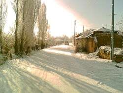
Ayrıdam, a village in Sorgun | |
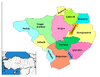 Location of Sorgun within Turkey. | |
 Sorgun Location of Sorgun within Turkey. | |
| Coordinates: 39°49′N 35°11′E / 39.817°N 35.183°E | |
| Country |
|
| Province | Yozgat |
| Government | |
| • Mayor | Ahmet Şimşek (AKP) |
| Area[1] | |
| • District | 1,782.41 km2 (688.19 sq mi) |
| Elevation | 1,080 m (3,540 ft) |
| Population (2012)[2] | |
| • Urban | 50,337 |
| • District | 82,944 |
| • District density | 47/km2 (120/sq mi) |
| Time zone | EET (UTC+2) |
| • Summer (DST) | EEST (UTC+3) |
| Postal code | 66xxx |
| Area code(s) | 0354 |
| Licence plate | 66 |
| Website | www.sorgun.gov.tr |
Sorgun is a town and district of Yozgat Province in the Central Anatolia region of Turkey. Sorgun is the largest and the most populated district of Yozgat. It covers an area of 1,769 km² and the population is 120,262 of which 53,884 live in the town of Sorgun (2000 census).[3]
Notes
- ↑ "Area of regions (including lakes), km²". Regional Statistics Database. Turkish Statistical Institute. 2002. Retrieved 2013-03-05.
- ↑ "Population of province/district centers and towns/villages by districts - 2012". Address Based Population Registration System (ABPRS) Database. Turkish Statistical Institute. Retrieved 2013-02-27.
- ↑ Turkish Statistical Institute. "Census 2000, Key statistics for urban areas of Turkey" (in Turkish). Archived from the original (XLS) on 2007-07-22. Retrieved 2008-03-22.
References
- Falling Rain Genomics, Inc. "Geographical information on Sorgun, Turkey". Retrieved 2008-03-22.
External links
- District governor's official website (Turkish)
- District municipality's official website (Turkish)
- A web portal of Sorgun (Turkish)
Coordinates: 39°48′52″N 35°11′25″E / 39.81444°N 35.19028°E
This article is issued from Wikipedia - version of the 8/16/2016. The text is available under the Creative Commons Attribution/Share Alike but additional terms may apply for the media files.