Solway Firth
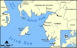
The Solway Firth (Scottish Gaelic: Tràchd Romhra) is a firth that forms part of the border between England and Scotland, between Cumbria (including the Solway Plain) and Dumfries and Galloway. It stretches from St Bees Head, just south of Whitehaven in Cumbria, to the Mull of Galloway, on the western end of Dumfries and Galloway. The Isle of Man is also very near to the firth. The firth comprises part of the Irish Sea.
The coastline is characterised by lowland hills and small mountains. It is a mainly rural area with fishing and hill farming (as well as some arable farming) still playing a large part in the local economy, although tourism is increasing. It has also been used for the location of films such as The Wicker Man (starring Edward Woodward), which was filmed around Kirkcudbright.
The Solway Coast was designated an Area of Outstanding Natural Beauty in 1964.[1] Construction of Robin Rigg Wind Farm began in the firth in 2007.
Wildlife
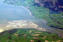
The water itself is generally benign with no notable hazards excepting some large areas of salt and mud flats, which often contain dangerous patches of quicksand that move frequently. It is recommended that visitors do not attempt to navigate them without expert guidance.
There are over 290 square kilometres (110 sq mi) of Sites of Special Scientific Interest (SSSIs) in the area, as well as national nature reserves at Caerlaverock and in Cumbria.[2] Salta Moss is one such SSSI.[3] On the Cumbrian side, much of the coastline is designated as an Area of Outstanding Natural Beauty. The Solway Coast AONB is split in two parts, the first runs from just north of Carlisle in a westerly direction as far as Skinburness, and the second runs from the hamlet of Beckfoot in a southerly direction past Mawbray and Allonby as far as Crosscanonby.
The honeycomb worm and blue mussel were designated as conservation targets in 2013, as Allonby Bay - an inlet of the Solway Firth - was put forward as a candidate for a Marine Conservation Zone.[4][5]
Long-distance walking route
A 53-mile (85 km) long-distance walking route, the Annandale Way,[6] runs through Annandale, from the source of the River Annan, in the Moffat Hills, to the Solway Firth; it was opened in September 2009.[7]
Islands in the Solway
Unlike other parts of the west coast of Scotland, the Solway Firth is generally devoid of islands. However, there are a few examples:
The Isle of Whithorn is actually a peninsula.
Rivers
The Solway Firth forms the estuary of the River Eden and the River Esk.
The following rivers also flow into the firth:
History
The name 'Solway' (recorded as Sulewad in 1218) is of Scandinavian origin,[8] and was originally the name of a ford across the mud flats at Eskmouth.[9] The second element of the name is Old Scandinavian vað 'ford'[8] (cognate with English wade). The first element is probably Old Scandinavian súl 'pillar', referring to the Lochmaben Stane, though súla 'solan goose' is also possible.[8] Súl and súla both have long vowels, but the early spellings of Solway indicate a short vowel in the first element.[9] This may be due to the shortening of an originally long vowel in the Middle English period but may also represent an original short vowel.[9] If this is the case, the first element may be *sulr, an unrecorded word cognate with Old English sol 'muddy, pool' or a derivative of sulla 'to swill'.[9]
The three fords in the area at that time were the Annan or Bowness Wath, the Dornock Wath (once called the Sandywathe), and the main one was the Solewath, or Solewath, or Sulewad.
In 1841 at Barnkirk Point (NY 1903 6425) a wooden structured light house was established. It was destroyed by fire in 1960.[10]
On 9th March 1876 a French 79 ton Lugger called the St . Pierre was stranded and finally declared lost on Blackshaw Bank, an ill-defined feature which extends for a considerable distance on both sides of the channel of the River Nith[11]
Between 1869 and 1921, the estuary was crossed by the Solway Junction Railway on a 1780 m (5850 ft) iron viaduct (Edgar and Sinton, 1990). The line was built to carry iron ore from the Whitehaven area to Lanarkshire and was financed and operated by the Caledonian Railway of Scotland. The railway was not a financial success. After the railway ceased operating, the bridge provided a popular footpath for residents of Scotland (which was dry on a Sunday) to travel to England where alcoholic drink was available. The viaduct was demolished between 1931 and 1933.
Hazards
The Ministry of Defence had by 1999 fired more than 6,350 depleted uranium rounds into the Solway Firth from its testing range at Dundrennan Range.[12] The adjacent Irish Sea is a carrier of radioactive pollution as Sellafield is nearby.
See also
References
- ↑ "Solway Coast AONB". Retrieved 2009-08-10.
- ↑ "South Solway Mosses NNR", Natural England
- ↑ "Natural England - Salta Moss SSSI" (PDF). Retrieved 14 January 2015.
- ↑ "Irishsea.org - Allonby Bay rMCZ" (PDF). Retrieved 14 January 2015.
- ↑ "The Wildlife Trusts - Allonby Bay" (PDF). Retrieved 14 January 2015.
- ↑ Annandale Way website
- ↑ The Long Distance Walkers Association - Annandale Way
- 1 2 3 Mills, A. D. (2011). A Dictionary of British Place Names. Oxford: Oxford University Press. p. 427.
- 1 2 3 4 Williamson, May G. (1942). The Non-Celtic Place-names of the Scottish Border Counties (PDF). University of Edinburgh (Unpublished PhD Thesis). p. 124. Archived from the original (PDF) on 2014-08-21.
- ↑ https://www.unc.edu/~rowlett/lighthouse/sctsw.htm
- ↑ Whittaker, I G. (1998) Off Scotland: a comprehensive record of maritime and aviation losses in Scottish waters. Edinburgh. RCAHMS Shelf Number: E.5.14.WHI
- ↑ Rob Edwards. "Radiation at Solway range hits new high". Sunday Herald. Retrieved 2009-08-10.
Further reading
- Edgar, S. and Sinton, J.M., (1990), The Solway Junction Railway, Locomotion Papers No. 176, The Oakwood Press, ISBN 0-85361-395-8
- Neilsen, George (1899). "Annals of Solway — Until A.D. 1307". In Forbes, Peter. Transactions of the Glasgow Archaeological Society. New Series. III. Glasgow: James Maclehose & Sons. pp. 245–308. (available at books.google.com)
- Ordnance Survey, (2003), Carlisle & Solway Firth, Landranger Map, No. 85, Ed. D, Scale 1:50 000 (1¼ inches to 1 mile), ISBN 0-319-22822-3
- Ordnance Survey, (2006), Solway Firth, Explorer Map, No. 314, Ed. A2, Scale 1:25 000 (2½ inches to 1 mile), ISBN 0-319-23839-3
Coordinates: 54°45′N 3°40′W / 54.750°N 3.667°W