Solitario
| Solitario | |
|---|---|
 | |
| Highest point | |
| Elevation | 4,619 ft (1,408 m) [1] |
| Prominence | 1,000 ft (300 m) |
| Coordinates | 29°27′03″N 103°48′32″W / 29.45083°N 103.80889°WCoordinates: 29°27′03″N 103°48′32″W / 29.45083°N 103.80889°W [1] |
| Geography | |
 Solitario Location: Brewster County and Presidio County | |
| Topo map | USGS The Solitario |
| Geology | |
| Mountain type | Laccolith |
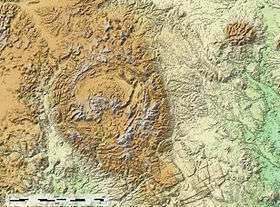
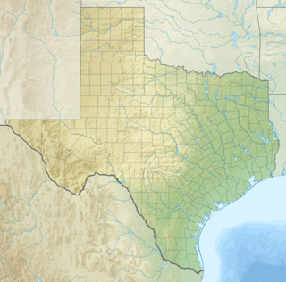
The Solitario is a large geologic formation in Big Bend Ranch State Park in West Texas. Viewed from above it suggests an impact crater, though it is actually the eroded remains of a laccolith. The approximate center of the Solitario is located 56.8 km (35.3 mi) east southeast of Presidio, Texas, just west of the line dividing Brewster County, Texas and Presidio County, Texas. The formation covers a circular area of approximately 135 km2 (52 sq mi). The geology of the Solitario is complex. In 1988 the state of Texas purchased the property containing the Solitario and created Big Bend Ranch State Park.
The formation lies in the Chihuahuan Desert ecoregion of the United States.
Geology
The Solitario is a structural dome developed in Paleozoic and Cretaceous rocks above an Eocene granite laccolith intrusion. The dome is associated with radial rhyolite to trachyte dikes and sills and erupted ash flow tuffs. The 16 km diameter dome contains a 6 by 2 km volcanic cauldera filled with collapse breccia, tuff, and trachyte lava.[2]
The Paleozoic rocks of the dome consist of a 2.6 km thick section of intensely folded Cambrian through Early Pennsylvanian sediments. The Paleozoic rocks were deformed and thrust into the area from the southeast during the Ouachita orogeny. Following the Permian uplift and erosion during most of the Mesozoic was followed by deposition of Cretaceous carbonate rocks which correlate with the Cretaceous of the Gulf Coast. The area was uplifted by the Laramide orogeny during latest Cretaceous. Following the Eocene intrusive and volcanic events of the Solitario, the area was partially covered by volcanic rocks from the adjacent Bofecillos volcanic center to the west of the area during the Oligocene and early Miocene. Erosion and downcutting following the Pleistocene deepening of the Rio Grande to the southwest and south have produced the current topographic expression of the area.[3]
See also
| Wikimedia Commons has media related to Big Bend Ranch State Park. |
References
- 1 2 "The Solitario". Geographic Names Information System. United States Geological Survey.
- ↑ Henry, Christopher D.; Kunk, Michael J.; Muehlberger, William R.; McIntosh, W.C. (August 1997). "Igneous evolution of a complex laccolith-caldera, the Solitario, Trans-Pecos Texas: Implications for calderas and subjacent plutons" (PDF). GSA Bulletin. 109 (8): 1036–1054.
- ↑ Corry, Charles E.; Herrin, Eugene; McDowell, Fred W.; Phillips, Kenneth A. (1990). The Geology of the Solitario. Geological Society of America.
External links
- Big Bend Ranch State Park.
- Flora and Vegetation of the Solitario Dome, Jean Evans Hardy, Iron Mountain Press - 2009
- Photos of West Texas