Skipwith
| Skipwith | |
 St Helen's parish church |
|
 Skipwith |
|
| Population | 266 (2011 Census)[1] |
|---|---|
| OS grid reference | SE6638 |
| Civil parish | Skipwith |
| District | Selby |
| Shire county | North Yorkshire |
| Region | Yorkshire and the Humber |
| Country | England |
| Sovereign state | United Kingdom |
| Post town | Selby |
| Postcode district | YO8 |
| Dialling code | 01757 |
| Police | North Yorkshire |
| Fire | North Yorkshire |
| Ambulance | Yorkshire |
| EU Parliament | Yorkshire and the Humber |
| UK Parliament | Selby |
| Website | Skipwith |
Coordinates: 53°50′19″N 0°59′48″W / 53.8387°N 0.9966°W
Skipwith is a village and civil parish about 4 miles (6.4 km) northeast of Selby in the Selby District of North Yorkshire, England. Until the 1974 local government reorganisation Skipwith was part of the East Riding of Yorkshire.
Archaeology
There are Bronze Age tumuli on Skipwith Common. Iron Age remains include a set of tumuli and a triple-bank system that runs roughly north–south across the Common and links with a settlement visible as crop marks of hut circles and other features in fields next to the Common on the north side. The remains of a Romano-British enclosure on the northern part of Skipwith Common near the present village.
Manor
The Domesday Book records that by 1086 Robert de Stutville held a carucate of land at Skipwith.[2] His family held a manor here until 1229, when it passed to Hugh Wake by his marriage to Joan de Stutville.[2] In 1325 it passed to Edmund of Woodstock, 1st Earl of Kent by his marriage to Margaret Wake, 3rd Baroness Wake of Liddell.[2] It remained with his heirs until 1418,[2] a decade after their line became extinct with the death of Edmund Holland, 4th Earl of Kent in 1408.[2]
Churches
Church of England
The oldest parts of the Church of England parish church of Saint Helen are Saxon. The west tower began as a porch, but in the 11th century upper stages were added to turn it into a tower.[3] The tower is linked with the nave by a characteristic Saxon plain Romanesque round arch,[3] so the nave must also have originally been Saxon.
A Norman north aisle of two bays was added to the nave in about 1190, linked with the nave by an arcade of pointed arches.[3] This was followed by the south aisle, whose arcade has octagonal columns.[3] The nave and aisles were then extended eastwards with the addition of a third bay.[3]
The present chancel was built about 1300.[4] It is lofty and has large, square-headed windows with Decorated Gothic tracery.[4] The chancel windows were glazed with medieval stained glass, fragments of which survive.[3]
In the 15th century the tower was raised again with the addition of a new bell-stage above the 11th-century Saxon one.[3] In the 16th century, possibly after the English Reformation, a clerestory was added to the nave and new square-headed windows were inserted in the north aisle.[3]
In 1821–22 the Gothic Revival south porch was added,[5] and in 1877 the church was carefully restored under the direction of John Loughborough Pearson.[3] Notably, the south door was replaced but re-using its original 13th-century ironwork.[3] St Helen's is now a Grade I listed building.[5]
St Helen's parish is now part of a joint benefice with the parish of Bubwith with Ellerton and Aughton.[6]
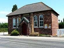
Methodist
Two families in Skipwith were Methodists by 1764.[2] The village's Methodists worshipped in each other's homes until 1833, when a Wesleyan Methodist chapel was built.[2] In the 1860s the Vicar of St Helen's claimed that 300 or 400 of the villagers were Methodists.[2] In 1876 the first chapel was replaced with a larger brick one next to the parish school.[2]
The chapel is now Skipwith Methodist Church.[2] It is a member of the Goole and Selby Methodist Circuit.[7]
Historic secular buildings

Skipwith Hall is early in the 18th century house of seven bays and two and a half storeys,[3] flanked by a three-bay wing on each side.[8] It is now a Grade II* listed building.[9]
A school and schoolmaster's house built in 1714,[8] founded and endowed by the bequest of a Dorothy Wilson.[2][10] In the 1851 its pupils included 11 boarders, and in the 1860s a separate classroom for girls was added.[2] In 1871 the school had 54 pupils but in 1872 this fell to only 30.[2] From the 1900s to the 1930s the school averaged 30–40 pupils, but in 1938 this had declined to 26.[2] In 1957 the school was closed and its pupils were transferred to Thorganby.[2] Since 1959 the school has served as the village hall.[2]
0.5 miles (800 m) southwest of the village is the site of RAF Riccall, a training airfield that was a heavy bomber conversion unit in the Second World War.
Amenities
Skipwith has a public house, the Drovers Arms, which is now a gastropub.[11]
Skipwith Common
.JPG)
Skipwith Common has remnants of ancient sand dunes.
The lowland heath is entirely man-made, relying on land clearances followed by grazing, peat cutting, etc. The Common has been a resource for local residents until relatively modern times as timber for building, turf and peat for fuel, bracken for bedding and soap-making, reeds for thatching, rushes for bedding and floor covering as well as wicks for lighting, and the while grazed by livestock including cattle, sheep and geese.
Until the First World War the Common was almost treeless. Only since grazing ceased in relatively modern times have trees started to re-establish on the Common.
Two ponds close to Skipwith village on Common Road, called the Line Ponds, are believed to have been used for flax-retting (the process of immersing the flax stems in water to soften the outer husk before preparing the inner fibres to make linen). In the Second World War RAF Riccall was built on the western end of the Common and much of the infrastructure, one of the runways, and other features survive both on and next to the Common on both north and south sides.
In about 1957 the area was made a Site of Special Scientific Interest. The Yorkshire Wildlife Trust and English Nature (since 2006 Natural England) cleared trees and scrub to restore the lowland heath that had been lost to silver birch regeneration. In 2009 the site was made a national nature reserve.
The site is more than 600 acres (240 ha): about 50% lowland heath and 50% woodland. Two types of heather are present and recolonising the freshly cleared areas. Areas of swamp and mire are habitats for sphagnum moss and rare flora and fauna, together with fen and reed-beds, ponds, rushy areas and grassland. An historic breed of longhorn cattle, hardy Hebridean sheep and Exmoor pony plus a herd of wild fallow deer and roe deer now graze the Common to help to prevent silver birch regeneration.
References
- ↑ "Area: Skipwith (Parish), Key Figures for 2011 Census: Key Statistics". Neighbourhood Statistics. Office for National Statistics. Retrieved 27 October 2013.
- 1 2 3 4 5 6 7 8 9 10 11 12 13 14 15 16 Allison 1976, pp. 89–101
- 1 2 3 4 5 6 7 8 9 10 11 Pevsner 1972, p. 341
- 1 2 Pevsner 1972, p. 340
- 1 2 "Church of Saint Helen". National Heritage List for England. English Heritage. 17 December 1966. Retrieved 27 October 2013.
- ↑ Archbishops' Council (2010). "St Helen, Skipwith". A Church Near You. Church of England. Retrieved 27 October 2013.
- ↑ "Skipwith Methodist Church.". Churches. Goole and Selby Circuit. 2013. Retrieved 27 October 2013.
- 1 2 Pevsner 1972, p. 342
- ↑ "Skipwith Hall". National Heritage List for England. English Heritage. 25 October 1951. Retrieved 27 October 2013.
- ↑ "Village Hall and School House". National Heritage List for England. English Heritage. 17 December 1966. Retrieved 27 October 2013.
- ↑ Drovers Arms at Skipwith
Sources and further reading
- Allison, K.J. (editor); Baggs, A.P.; Kent, G.H.R.; Purdy, J.D. (1976). A History of the County of York East Riding. Victoria County History. 3 – Ouse and Derwent wapentake, and part of Harthill wapentake. pp. 89–101.
- Pevsner, Nikolaus (1972). Yorkshire: York & the East Riding. The Buildings of England. Harmondsworth: Penguin Books. pp. 340–342. ISBN 0-14-071043-4.
External links
| Wikimedia Commons has media related to Skipwith. |