Skhidnytsia
| Skhidnytsia Східниця | |||
|---|---|---|---|
| Urban settlement | |||
| |||
 Skhidnytsia | |||
| Coordinates: UA 49°13′25″N 23°21′11″E / 49.22361°N 23.35306°ECoordinates: UA 49°13′25″N 23°21′11″E / 49.22361°N 23.35306°E | |||
| Country |
| ||
| Province |
| ||
| Municipality | Boryslav | ||
| Established | 15th century | ||
| Area | |||
| • Total | 6,9 km2 (27 sq mi) | ||
| Elevation/(average value of) | 750 m (2,460 ft) | ||
| Population (2016) | |||
| • Total | 2,255 | ||
| • Density | 33/km2 (85/sq mi) | ||
| Time zone | EET (UTC+2) | ||
| • Summer (DST) | EEST (UTC+3) | ||
| Postal code | 82391 | ||
| Area code | +38(03248) | ||
| Website | селище Східниця (Ukrainian) | ||

Skhidnytsia (Ukrainian: Схі́дниця) is an urban-type settlement in Lviv Oblast, Western Ukraine. The town is part of Boryslav Municipality, and represented by local Skhidnytska settlement council. Population: 2,255 (2016 est.)[1].
Description
Skhidnytsia located at an altitude of 600 metres (2,000 ft) – 900 metres (3,000 ft) above sea level. The mountains around the town reach a height of 823 metres (2,700 ft).
Distance to the regional center of Lviv is 102 kilometres (63 mi), to the Boryslav – 14 kilometres (8.7 mi) and to the Drohobych is 25 kilometres (16 mi).
The settlement Skhidnytsia first mentioned in the documents of the 15th century.
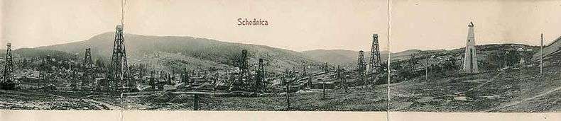
The urban-type settlement Skhidnytsia is known for its deposits mineral waters. For today there are 38 sources and 17 wells with different chemical composition of mineral water.[2]
Skhidnytsia in the past
Gallery


.png)
 Abandoned oil pump

References
- ↑ "Чисельність наявного населення України (Actual population of Ukraine)" (PDF) (in Ukrainian). State Statistics Service of Ukraine. Retrieved 19 July 2016.
- ↑ Around region excursions: Skhidnytsia and Morshyn
External links
- The Skhidnytsia resort
- Skhidnytsya settlement: street map, description
- weather.in.ua
- Resorts and hotels of Skhidnytsa
- Virtual tour of the resort Skhidnytsya, 3D panorama photos