Vía de la Plata

The Vía de La Plata (Silver Way) or Ruta de la Plata (Silver Route) is an ancient commercial and pilgrimage path that crosses the west of Spain from north to south, connecting Mérida to Astorga. An extended form begins further south in Seville and reaches north to the Bay of Biscay at Gijón. The path is used by the modern A-66 and AP-66 freeways, as well as by the older N-630 national road.
Name
The term Vía de la Plata is commonly thought to use from the modern Spanish word for silver, plata. The name actually derives from the Arabic word al-balat, which means cobbled paving and described the road as engineered by the Romans.[1]
Pre-Roman era
The historical origins of this route are uncertain. It is believed, based on diverse archaeological findings, that the route was used for commercial purposes involving tin. Tin was present in many regions of the Iberian Peninsula including Tartessos.
Roman causeway
The "Tin Way" was used as an access road, which allowed the Romans to conquer tribes such as the Callaici, the Astures, and the Vacceos. Many sources, among them the Antonine Itinerary, describe the route to leave from Emerita Augusta, (present-day Mérida), capital of Lusitania, towards Asturica Augusta (present-day Astorga) through Tarraconensis.
The road contains physical evidence that shows a Roman constructed road (called the, or a, via lata, meaning "broad road") that has been almost unchanged at various sections. It was conceived and built as a trade route for the exploitation of gold, as mentioned by Pliny the Elder who held high office as Procurator in Hispania Tarraconensis in 73 AD. It ran from Asturica Augusta (Astorga) in Northwestern Spain, to Emerita Augusta (Mérida) in southwestern Spain. The road's first official name was Via Delapidata (meaning "Paved Stone Way"), stretched around 900 km (560 mi), and had a branch that joined with the Via Augusta (or Via Heraclea). After its establishment, the Via Delapidata crossed Hispania from Cádiz, through the Pyrenees, towards Gallia Narbonensis (southern France) and Rome in the Italian Peninsula. Currently, the road passes through Salmantica (Salamanca), Metelinum (Medellín), and Castra Caecilia (Cáceres). The Via Delapidata also served as an access road from Hispania Baetica.
During the Roman Empire it is known that it was used to connect two main areas of the highest importance at both end, the gold mines of Las Medulas and the copper mines of Rio Tinto.
Modern times
The suitability of the route's layout is demonstrated even today. It is used by modern A-66 and AP-66 freeways as well as by older N-630 national road. Some stretches, however, pass through urban areas like Seville, where the Vía de la Plata runs along the Guadalquivir. The Vía de la Plata has become increasingly popular as an alternative to the French Way for pilgrims walking, cycling, or riding to Santiago de Compostela. Large sections are more or less the same as they were two thousand years ago.
Gallery
-

map of Roman roads in Hispania.
-

The Tagus was negotiated by the almost 300 m long Alconétar Bridge.
-

Roman theater Mérida
-

Guadiana river, Mérida
-
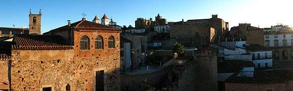
Cáceres
-

Miliario de Nerón, Cáparra city, north of Cáceres
-
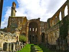
Moreruela Abbey (Zamora)
-

Remains of Castrotorafe Castle (Zamora)
-

Zamora
-

La Clerecía, Salamanca
-

Pilgrims coming to Salamanca by Vía de la Plata.
-

San Esteban Church, Salamanca
-

Castle ruins just after El Real de la Jara
See also
References
- ↑ Antonio Migu Nogues-Pedregal, "When the Desirable and the Feasible Converge Through Tourism Space," in Antonio Migu Nogues-Pedregal, ed., Culture and Society in Tourism Contexts (Emerald Group Publishing, 2012), 82, available online, accessed May 27, 2013
External links
| Spain |
|  |
|---|---|---|
| France |
| |
| Portugal |
| |
| Switzerland | ||
| Poland |
| |
| ||