Sillanwali
| سِلانٚوالى | |
|---|---|
| City | |
| Sillanwali | |
|
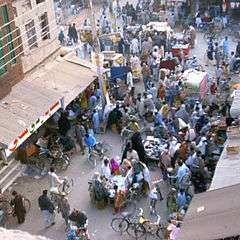
Aerial view of the Main Bazaar at Sillanwali | |
 سِلانٚوالى | |
| Coordinates: 31°29′N 72°19′E / 31.49°N 72.32°ECoordinates: 31°29′N 72°19′E / 31.49°N 72.32°E | |
| Country |
|
| Elevation | 173 m (568 ft) |
| Time zone | PST (UTC+5) |
| Calling code | 0992 |
Sillanwali (Punjabi,Urdu: سِلانٚوالى), is a town of Sargodha District in the Punjab province of Pakistan. The town is tehsil headquarters of Sillanwali Tehsil.[1] It is situated at 31°49'45N 72°32'22E,[2] lying in the southern area of Sargodha, bordering with Jhang District in the Bhatiore area. Population is mainly Muslim and Punjabi speaking.
History
The town developed in the late 19th century during the rule of the British empire. It was planned to be an agricultural business hub or mandi ("wholesale market").
It was a planned town developed after canals were built for agricultural purposes and a railway line was established. Even today, the railway station at Sillanwali is known as "Sillanwali Mandi" in railway records. Before the Partition of India in 1947, Sillanwali was well known for the production of cotton. Most of the population were Hindu Khatris. After partition the Hindus migrated to India and their property was taken over by the Muslim Sheikhs (having Khatri Origin), most of whom had migrated from Karnal District of Haryana state which had been part of united Punjab but became part of Indian Punjab after 1947.
At the same time, Jat Sikhs migrated to India, and members of the Rajput, Arain, Khokhar, Sheikh, Rehmani Gujjar and Dogar moved to Silanwali and the surrounding villages.
Sufi tomb
The dargah (tomb and shrine) of Pir Muhammad Barkhudar Gilani Qadri is located in Silanwali. It is the oldest and most celebrated dargah in the area. Urs is held annually on March 1. Hundreds of murids attend this event from different cities and regions, as well as local people.
Neighborhoods

The old city is divided into 4 blocks and a colony known as Bashir colony. Block No. 4 is well developed amongst all. There are many intellectuals live in Block No.4. The main neighborhoods of Sillanwali are Islam Nagar, Shareef Colony, People's Colony, Chanan Pura, Dhaulka Town, Noon Colony, Rana Market, Model Town, Aslam Colony, Beegi Purra, Zaffarabad, Nishat Abad, Rehman Purra, Garden Town Aziz Park nishatabad and Rana Nadeem Park. The popular nabhoyr of Sillanwali is 121 nb.
Schools
Among several high schools in town, Govt High school No.1 & Govt High school No.2 are famous and providing education. There are two degree colleges in Sillanwali (one for boys & second for girls). Two high schools for girls.A number of private schools & colleges are facilating the people in terms of good education A Dar-ul-Ilm Model School 121nb providing excellent education to students.
Economy
Sillanwali is famous for its woodwork handicrafts, which are largely exported to other cities, provinces and even to other countries and orange farms.
Hospitals
There are two hospitals in the city. One was Rural Health Center(RHC) now updated to Tehsil Head Quarters(THQ) Hospital Sillanwali. And the second is Civil Dispencary that is situated at Railway Road.
