Sierra de Gúdar
| Sierra de Gúdar | |
|---|---|
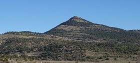 The Cabezo de las Cruces peak, located at the border between Aragón and the Valencian Community. | |
| Highest point | |
| Elevation | 2,019 m (6,624 ft) |
| Listing | Mountains of Aragon, List of mountains in the Valencian Community |
| Coordinates | 40°22′25″N 0°37′56″W / 40.37361°N 0.63222°WCoordinates: 40°22′25″N 0°37′56″W / 40.37361°N 0.63222°W |
| Geography | |
 Sierra de Gúdar Spain | |
| Location |
Gúdar-Javalambre, Maestrazgo, Aragon |
| Parent range | Iberian System, Eastern zone |
| Geology | |
| Mountain type | Limestone (Post-Miocene) |
| Climbing | |
| Easiest route | From the towns of Valdelinares, Rubielos de Mora, Linares de Mora or Mosqueruela |
Sierra de Gúdar is a mountain range in the Gúdar-Javalambre and Maestrazgo comarcas of Aragon and the Alto Mijares comarca of the Valencian Community, Spain. The highest point in the range is Peñarroya (2,019 m).[1]
Geography
This mountain range is located at the eastern end of the Iberian System and the Sierra de Nogueruelas is its easternmost prolongation. The Sierra Mayabona is another subrange of the Sierra de Gúdar.
Its summits are usually covered in snow in the winter and the 1710 m high Cabezo de las Cruces is one of the highest peaks of the Land of Valencia.
Mora de Rubielos is the most important town in this mountainous zone. The range is named after the town of Gúdar. Valdelinares, also a village in the area, is the highest town in Aragon.[2]
See also
References
External links
 Media related to Sierra de Gúdar at Wikimedia Commons
- Sierra de Gúdar - Monumentos y rutas en Gúdar - Teruel - Turismo
- Sierra de Gúdar