Geography of Peru
 | |
| Continent | South America |
|---|---|
| Coordinates | 10°00′S 76°00′W / 10.000°S 76.000°W |
| Area | Ranked 20th |
| • Total | 1,285,215.6 km2 (496,224.5 sq mi) |
| • Land | 99.6% |
| • Water | 0.4% |
| Coastline | 2,414 km (1,500 mi) |
| Borders |
Total land borders: 7,461 km Bolivia: 1,075 km Brazil: 2,995 km Chile: 171 km Colombia: 1,800 km Ecuador: 1,420 km |
| Highest point |
Huascarán Sur, 6,768 metres (22,205 ft) |
| Lowest point |
Bayóvar Depression, −34 metres (−112 ft) |
| Largest lake | Lake Titicaca |


Peru is a country on the central western coast of South America facing the Pacific Ocean.
Statistics
Area:
land:
1,279,999 km²
water:
5,220 km²
Maritime claims:
continental shelf:
200 nmi (370.4 km; 230.2 mi)
territorial sea:
200 nmi (370.4 km; 230.2 mi)
Land use:
arable land:
3%
permanent crops:
0.5%
permanent pastures:
21%
forests and woodland:
66%
other:
9.5% (1993 est.)
Irrigated land: 12,800 km² (1993 est.)
Natural hazards: earthquakes, tsunamis, flooding, landslides, mild volcanic activity
Environment - current issues: deforestation (some the result of illegal logging); overgrazing of the slopes of the coast and sierra leading to soil erosion; desertification; air pollution in Lima; pollution of rivers and coastal waters from municipal and mining wastes
Environment - international agreements:
party to:
Antarctic Treaty, Antarctic-Environmental Protocol, Biodiversity, Climate Change, Desertification, Endangered Species, Hazardous Wastes, Nuclear Test Ban, Ozone Layer Protection, Ship Pollution, Tropical Timber 83, Tropical Timber 94, Wetlands, Whaling
signed, but not ratified:
Climate Change-Kyoto Protocol
Geography - note: shares control of Lake Titicaca, world's highest navigable lake, with Bolivia
Climate
The combination of tropical latitude, mountain ranges, topography variations and two ocean currents (Humboldt and El Niño) gives Peru a large diversity of climates. Perù has a tropical climate with a wet and dry season.
Amazon Basin or Low Amazon
The eastern portions of Peru include the Amazon Basin or selva baja, a region that is larger in the north than in the south. Representing roughly 60% of Peru's national territory, this area includes the Amazon, Marañón, Huallaga and Ucayali Rivers. It is a vast tropical forest with countless rivers and streams.
Almost 60% of the country's area is located within this region,[1] (700,000 km2 or 270,000 sq mi) giving Peru the fourth largest area of tropical forest in the world after Brazil, Congo and Indonesia.[2]
Andean Mountain Ranges
The Andes shelter the largest variety of climates in the country. The climate is semi-arid in the valleys and moist in higher elevations and towards the eastern flanks. Rainfall varies from 200 to 1,500 mm (7.9 to 59.1 in) per year. The rainy season starts in October and ends in April. The rainiest months are January through March where travel can be sometimes affected.
The western slopes are arid to semi-arid and receive rainfall only between January and March. Below the 2,500 m (8,202 ft) mark, the temperatures vary between 5 and 15 °C (41 and 59 °F) in the night versus 18 to 25 °C (64.4 to 77.0 °F) in the day.
Between 2,500 and 3,500 meters (8,202 and 11,483 ft) the temperatures vary from 0 to 12 °C (32.0 to 53.6 °F) in the night and from 15 to 25 °C (59 to 77 °F) during the day. At higher elevations from 3,500 to 4,500 meters (11,483 to 14,764 ft), the Puna ecoregion, the temperature varies from −10 to 8 °C (14.0 to 46.4 °F) during the night versus 15 °C (59 °F) during the day.
The northernmost regions of the Andes around Cajamarca and Piura regions have Páramo climates.
Coast
The Peruvian coast is a microclimatic region. The region is affected by the cold Humboldt Current, the El Niño Southern Oscillation, tropical latitude, and the Andes mountain range.
The central and southern coast consists mainly of a subtropical desert climate composed of sandy or rocky shores and inland cutting valleys. Days alternate between overcast skies with occasional fog in the winter and sunny skies with occasional haze in the summer, with the only precipitation being an occasional light-to-moderate drizzle that is known locally as garúa. These regions are usually characterized by having mildy cold lows (14 °C or 57.2 °F) and also mild highs (29 °C or 84 °F). Temperatures rarely fall below 12 °C (53.6 °F) and do not go over 29 °C (84 °F). An exception is the southern coast, where it does get a bit warmer and drier for most of the year during daytime, and where it can also get much colder during winter nights (8 to 9 °C or 46.4 to 48.2 °F). The occasional drizzle or fog of the central and southern coast is common during winter months, but even during summer days there are some foggy days. One must not forget that although it may not be as warm as typical tropical latitudes, the sun will hit and strike as if you were in any other tropical place.
The northern coast, on the contrary, has a curious tropical-dry climate, generally referred to as tropical savanna. This region is a lot warmer and can be unbearable during summer months, where rainfall is also present. The region differs from the southern coast by the presence of shrubs, equatorial dry forests, mangrove forests, tropical valleys near rivers such as the Chira and the Tumbes, and is blessed with clear, sunny skies for most of the year. The average temperature is 25 °C (77 °F).
Central & Southern Coast
The central and southern coast have a subtropical desert climate, despite this region being located in the tropics. The Humboldt Current, serving as one cause of climactic differentiation, is 7 to 8 °C (13 to 14 °F) colder than normal tropical seas at 14 to 19 °C (57 to 66 °F), thus preventing high tropical temperatures from appearing. Additionally, due to the height of the Andes cordillera, there is no passage of hot clouds from the Amazon to the coast, the climate is cooler than that of similar tropical latitudes. This can create a great deal of humidity and fog during winter months.
Moreover, the Andes mountains are very close to the coast, a geographic factor that prevents cumulus or cumulonimbus clouds from appearing. Therefore, a shade effect is created, causing very low annual rainfall in this region.[3]
Rainfall averages 5 mm (0.2 in) per year near the Chilean border to 200 mm (7.9 in) per year on the northern coast and nearer the Andes.
The central coast is composed of regions including La Libertad, Ancash and Lima, which have a spring-like climate for most of the year. Foggy and sunny days intermingle around the humid sand dunes during most of the year.
Most summers (February–April) have pleasant temperatures ranging from 19 to 21 °C (66 to 70 °F) during the night to about 28 to 29 °C (82 to 84 °F) during daytime. Winters (August–October) are very humid, and range from 12 to 15 °C (54 to 59 °F) during the nights to around the 17 to 18 °C (63 to 64 °F) during the day. The spring (November–January) and autumn (May–July) months have a pleasant climate that ranges from 23 °C (73 °F) during the day to around 17 °C (63 °F) during the night. Moving inland into the Yunga valleys, the climate tends to be ~3 °C (5.4 °F) drier and warmer during any given month.
The southern coast, composed of the Ica, Arequipa, Moquegua and Tacna regions, has a drier and warmer climate during the day for all seasons, although colder in winter. There are regions famous for their sand dunes and impressive deserts that are, in part, caused by the drier and hotter climate. Temperatures in this region can reach up to 36 °C (97 °F) in the Nazca region while inland regions can fall to 8 or 9 °C (46 or 48 °F) during the winter months. During the day, temperatures rarely go below the 22 or 23 °C (72 or 73 °F) for all months of the year. This purports the idea that the southern coast has a more desert-like climate, although daily temperature variations exist as they do in other regions within tropical latitudes. Clear skies are often present in desert areas and, although less common, near the coastal cliffs as well, which are home to a variety of fish and marine mammals.
Northern Coast
The northern coast consists of the eastern region of Lambayeque, the Piura Region and the Tumbes Region. They are characterized by having different climate and geography from the rest of the coast. Right between the 3 hour drive on the Sechura desert, which is located north of the Lambayeque Region and south of the Piura Region, is the evidence of climate change from the common subtropical desert found on the south to visible tropicalization effects of the tropical dry climate or tropical savanna. Examples of this are the tropical dry forests that begin to appear. They are composed of shrubs, thorny trees, carrob trees, faique trees, huayacan trees, hualtaco trees, palo santo trees, ceibo trees and on the coast mangrove forests. It is also a biodiverse area where typical wildlife can be observed such as crocodiles, reptiles, iguanas, boas, pava aliblanca, anteater, bear, sloth (bearh) and many more.
This climatical reasons for change are the presence of the warm Niño Current during the summer months (December to April), the eventual El Niño Phenomenon and the passing of Amazon Jungles clouds due to mountain openings and lower altitudes of the Andes Chain. These are the causes for a climate change in a short two- or three-hour trajectory that is visible between the Lambayeque Region and the Sechura Province, where not only geography changes but a temperature rise of 6 °C (10.8 °F) or more depending on the month. It is directly off the shores of the Sechura Region where the cold Humboldt current and warm el Niño current meet, at about 5° to 6° south of the equator. From this point warm temperatures are most common, and there are no true winters. Average temperatures range between 24.5–27 °C (76.1–80.6 °F). Clear skies, beautiful warm valleys, eroded terrains with reddish colored sands, rice fields, palm trees, savannas, bushy forests, dense rivers, beautiful warm turquoise beaches, orangey or yellowish terrains, clearer sands and a sun that hits like the African plateau, where shade is almost impossible.
Summer (December through March) is more humid and very hot, with average temperatures that vary from 25 °C (77 °F) during the night to around 34 °C (93.2 °F) during the day, although north of Lambayeque it can reach the 40 °C (104 °F). Winters (June–September) are cooler during the nights; around 16 °C (60.8 °F) during the night, to around 27 °C (80.6 °F) during the daytime.
There are protected areas in Tumbes and Piura filled with tropical canelo forests and tropical dry forests such as Caza de Coto and Cerros de Amotape, both extending into southern Ecuador. The areas of eastern Lambayeque also have tropical dry forests, which are found in the Chaparri and Chongoyape provinces. These forests have the particularity of connecting to the Amazon basin through the Marañon passage (an area where there are also tropical dry forests). Mangrove forests are located in four specific areas from Sechura to Tumbes.
In these regions there are mangrove forests at the ending strips of the Piura River in the Sechura Province (the southernmost mangroves in the Pacific Ocean). To the north the ending strips of the Chira River, Tumbes River, and Zarumilla River also have mangrove forests that flow into the ocean.
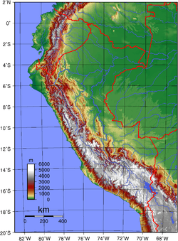
Terrain: western coastal plain (costa), high and rugged Andes in center (sierra), eastern lowland jungle of Amazon Basin (selva).
Natural resources: copper, silver, gold, petroleum, timber, fish, iron ore, coal, phosphate, potash, hydropower.
Extreme points
This is a list of the extreme points of Peru, the points that are farther north, south, east or west than any other location.
- Northernmost point: Putumayo River (00°01′48″S 75°10′29″W / 0.03000°S 75.17472°W) in the Putumayo District, Maynas Province, Loreto Region
- Southernmost point: Pacific shore (18°20′51″S 70°22′32″W / 18.34750°S 70.37556°W) in the Tacna District, Tacna Province, Tacna Region
- Westernmost point: Punta Pariñas (04°40′45″S 81°19′35″W / 4.67917°S 81.32639°W) in the La Brea District, Talara Province, Piura Region
- Easternmost point: Mouth of the Heath River (12°30′11″S 68°39′27″W / 12.50306°S 68.65750°W) in the Tambopata District, Tambopata Province, Madre de Dios Region
Antipodes
Parts of northern and southern Peru are antipodal to Southeast Asia. The north near the border with Ecuador is opposite much of Malaya, including the east coast and Penang, and the adjacent part of the Kra Peninsula in Thailand, whereas many of the Riau Islands of Indonesia are antipodal to the northern Peruvian Amazon. Southern Vietnam up to just north of Huế is antipodal to the southern Peruvian Amazon and Andes, with Saigon close to Atalaya, Peru, and Cuzco close to Pleiku, Vietnam. Cambodia apart from the westernmost part is antipodal to the Andes and the coast, including Lima, with Ayacucho not far from Stung Treng, and Huancayo not far from the Cambodian capital Phnom Penh. The famous Cambodian ruins of Ankor Wat are directly antipodal to the Peruvian city of Chincha Alta. The eastern corner of Thailand corresponds to coastal Peru around Nazca, and the south of Laos is antipodal to the coastal area just south of that. The southern cape of Hainan Island in China just overlaps the southern point of Peru.
References
- ↑ Instituto de Estudios Histórico–Marítimos del Perú, El Perú y sus recursos: Atlas geográfico y económico, p. 16.
- ↑ Painter= (December 7, 2008). "Peru aims for zero deforestation". BBC News.
- ↑ Moseley, M. 2001:26, The Incas and Their Ancestors: The Archaeology of Peru, Thames and Hudson.
External links
- Geofísico del Perú Geophysical Institute of Peru
- Instituto Geografico Nacional National Institute of Geography, Peru
| Wikimedia Commons has media related to Geography of Peru. |