Siby
| Siby | |
|---|---|
| Commune and village | |
 Siby Location in Mali | |
| Coordinates: 12°22′43″N 8°20′0″W / 12.37861°N 8.33333°WCoordinates: 12°22′43″N 8°20′0″W / 12.37861°N 8.33333°W | |
| Country |
|
| Region | Koulikoro Region |
| Cercle | Kati Cercle |
| Area[1] | |
| • Total | 1,001 km2 (386 sq mi) |
| Population (2009 census)[2] | |
| • Total | 26,633 |
| • Density | 27/km2 (69/sq mi) |
| Time zone | GMT (UTC+0) |
Siby is a village and rural commune in the Cercle of Kati in the Koulikoro Region of southern Mali. The commune contains 21 villages[3] and in the 2009 census had a population of 26,632. The village lies 50 km southwest of the capital, Bamako, on the plain to the south of the Monts Mandingues. The RN5 road that links Bamako with Siguiri in Guinea runs through the village.
History
The Mandé village of Siby was founded in the Middle Ages by ancestors of the Camara.
According to Sundiata Keita, the king of Siby, Kamandjan Kamara, whom Sundiata Keita knew from childhood, brought the kings of the tribes allied against Soumaoro Kanté, king of the Sosso, together at Siby.
The troops of Sundiata Keita had just won two battles against the Sossos at Negueboria in the Bouré and at Kangigné. In Siby, all the allied kings found themselves gathered around Sundiata Keita: Kamandjan Kamara, king of Siby, his cousin Tabon wana Fran Kamara, king of the Camara blacksmiths, Siara Kouman Diabaté, Faony Diarra Kondé, king of the country of Do, the country of Sogolon and the mother of Sundiata, Mansa Traoré. After a few days of rest, the allies went to Kirina where the decisive battle against Soumaoro Kanté took place.
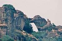
On the top of the mountain, an arch, from where one has a splendid sight on the surrounding plain, is dug in the rock. According to legend, it was Kamandjan Kamara who transpierced the mountain with his sabre the day before the departure, during an evening where Balla Fasséké asked each king present if he was able to do so.
References
- ↑ Plan de Sécurité Alimentaire Commune de Siby 2008-2012 (PDF) (in French), Commissariat à la Sécurité Alimentaire, République du Mali, USAID-Mali, 2008.
- ↑ Resultats Provisoires RGPH 2009 (Région de Koulikoro) (PDF) (in French), République de Mali: Institut National de la Statistique.
- ↑ Communes de la Région de Koulikoro (PDF) (in French), Ministère de l’administration territoriale et des collectivités locales, République du Mali.
- Djibril Tamsir Niane, Soundjata ou l'épopée mandingue, Présence africaine, Paris, 1960.
- Résultats provisoires du Recensement général de la population et de l'habitat 2009 [archive] sur Institut national de la statistique (Mali), 2010. Consulté le 18 mars 2010
See also
The city cooperates with Ramonville Saint Agne, France.
The first two editions of the Forum des peuples were held in Siby in 2002 and 2003.
 Old furnace dating from the Empire of Mali in the area of Siby
 Anvil of Niekema dominates the village of Siby enclume
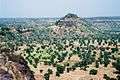 Landscape of Manding in the surroundings of Siby
| Wikimedia Commons has media related to Siby (Mali). |