Wind River Indian Reservation
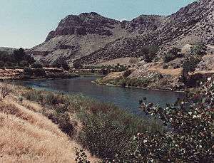
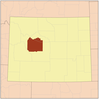

Wind River Indian Reservation is an Indian reservation made for the Eastern Shoshone and Northern Arapaho tribes of Native Americans in the central western portion of the U.S. state of Wyoming. It is the seventh-largest Indian reservation by area in the United States, encompassing a land area of 3,473.272 sq mi (8,995.733 km²), or land and water area of 3,532.010 sq mi (9,147.864 km²), encompassing just over one-third of Fremont County and over one-fifth of Hot Springs County.[1] The reservation is located in the Wind River Basin, and is surrounded by the Wind River Mountain Range, Owl Creek Mountains, and the Absaroka Mountains. The 2000 census reported a population of 40,237 inhabitants. The largest town is Riverton. Headquarters are at Fort Washakie. Also home to the Wind River Casino, Little Wind Casino, 789 Smoke Shop & Casino (all Northern Arapaho) and the Shoshone Rose Casino (Eastern Shoshone), which are the only casinos in Wyoming.
History
The Wind River Indian Reservation was established for the Eastern Shoshone Indians in 1868. Camp Augur, a military post with troops, was established at the present site of Lander on June 28, 1869. In 1870 the name was changed to Camp Brown and in 1871 the post was moved to the current site of Fort Washakie. The nickname was changed to honor the Shoshone Chief Washakie in 1878 and continued to serve as a military post until its abandonment in 1909.[2] A government school and hospital functioned for many years east of Fort Washakie and children were sent here to board during the school year. St. Michael's at Ethete was constructed in 1917-20. The village of Arapahoe was originally established as a sub-agency to distribute rations to the Arapaho and at one time had a large trading post. In 1906 a portion of the reservation was ceded to white settlement and Riverton evolved on some of this land. Lands were allotted in the 19th century to the various families and names were anglicized. Irrigation was brought in to develop farming and ranching and a flour mill constructed near Fort Washakie.[2]
On December 19th 2013, the EPA issued a decision granting environmental enforcement jurisdiction to the reservation authorities. The tribe later publicly asserted other jurisdictional rights in the areas diminished by the 1906 agreement. On January 6th 2014, the state issued a petition for stay and reconsideration of the environmental protection agency's decision. [3]
Of the population in 2011, 8,177 were Arapaho and 3,737 were Shoshone on 1,880,000 acres of Tribal Land with 180,387 acres of Wilderness area,[4][5] compared to the population in 2000, 6,728 (28.9%) were Native Americans (full or part) and of them 54% were Arapaho and 30% Shoshone. Of the Native American population, 22% spoke a language other than English at home. Sacagawea's interment occurred here. Her son Jean Baptiste Charbonneau has a memorial stone in Fort Washakie but his interment was in Danner, Oregon.
The reservation has received attention for crime and drug usage.[6] Locals refer to different streets by infamously violent American locations such as Compton.[7] Other residents say the Wind River Indian Reservation is often a more hopeful place than is portrayed in press reports.[8]
Communities


- Arapahoe
- Boulder Flats
- Crowheart
- Ethete
- Fort Washakie
- Hudson (part, population 72)
- Johnstown
See also
Notes
- ↑ 2000 Census, U.S. Census Bureau
- 1 2 Eastern Shoshone Tribal Culture
- ↑ http://ag.wyo.gov/wyoming-epa
- ↑ "2011/2012 Fishing Regulations, Shoshone and Arapaho Tribes, Wind River Indian Reservation Wyoming" (Press release). Fish and Game Department, Wind River Indian Reservation, Fort Washakie, Wyoming. Retrieved February 24, 2012.
- ↑ "Wind River Fish & Game - Home". Retrieved February 24, 2012.
- ↑ Johnson, Robert. "Here's What Life Is Like On The Notorious Wind River Indian Reservation". Business Insider. Retrieved 21 February 2013.
- ↑ Johnson, Robert. "Here's What Life Is Like On The Notorious Wind River Indian Reservation". Business Insider. Retrieved 21 February 2013.
- ↑ http://www.wyofile.com/blog/the-reservation-reacts-to-new-troubling-press-coverage/
External links
| Wikimedia Commons has media related to Wind River Indian Reservation. |
- Wind River Reservation and Off-Reservation Trust Land, Wyoming United States Census Bureau
- Tetona Dunlap (February 2012). "As elders pass, Wind River Indian Reservation teachers turn to technology to preserve Shoshone language". WyoFile. Retrieved 2012-02-29.
Coordinates: 43°16′51″N 108°48′55″W / 43.28083°N 108.81528°W
Municipalities and communities of Fremont County, Wyoming, United States | ||
|---|---|---|
| Cities | 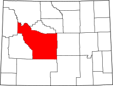 | |
| Towns | ||
| CDPs | ||
| Unincorporated communities | ||
| Ghost town | ||
| Indian reservation | ||
Municipalities and communities of Hot Springs County, Wyoming, United States | ||
|---|---|---|
| Towns | 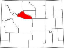 | |
| CDPs | ||
| Unincorporated community | ||
| Ghost town | ||
| Indian reservation | ||