Shoemaker (lunar crater)
|
| |
| Coordinates | 88°06′S 44°54′E / 88.1°S 44.9°ECoordinates: 88°06′S 44°54′E / 88.1°S 44.9°E |
|---|---|
| Diameter | 50.9 km |
| Depth | Unknown |
| Colongitude | 342° at sunrise |
| Eponym | Eugene Shoemaker |

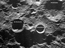
Shoemaker is a lunar crater that is located near the southern pole of the Moon, within half a crater diameter of Shackleton. It lies to the south of the crater Malapert, to the east of Haworth, and just to the west of the similar-sized Faustini. The rim of Shoemaker is circular and worn, with some small craters along the inner wall. Due to the lack of illumination (it is a crater of eternal darkness), the albedo of the interior floor surface remains unknown.
Prior to being given its current name by the IAU, this formation had been informally named Mawson (after the Antarctic explorer Douglas Mawson). It was officially named Shoemaker in honor of Eugene Shoemaker, the geologist whose remains were on board the Lunar Prospector spacecraft that impacted this crater floor.
Cold trap deposits
This crater became of interest to scientists when the Lunar Prospector detected unusually high concentrations of hydrogen on the floor of this and other nearby craters using a neutron spectrometer. The floor of this crater is kept in permanent shadow from the Sun, and thus maintains a temperature below 100 K. Thus the floor forms a cold trap, and any molecules of water that wander into the crater from cometary impacts can deposit on the floor and remain there almost permanently. The instruments on board Lunar Prospector gave a concentration of about 146 ppm of hydrogen, compared to 50 ppm for the average lunar surface.
The topography of this crater was subsequently measured using the Goldstone 70-meter antenna to irradiate it with 3.5 cm radar. Two 34-meter antennae, located 20 kilometers apart, received the echoes, and the results were used to generate a topographic map with 150 m resolution.[1]
On July 31, 1999, Lunar Prospector was deliberately crashed into the floor of this crater to determine if a plume of water vapor would be detected. The apparent detection of water and the shallow rim of this crater made it a suitable target for this experiment. However the outcome was unsuccessful. Subsequent tests have failed to confirm the presence of water in the crater floor, so the hydrogen found in the crater bottom is likely to prove more difficult to extract than had been originally hoped.
References
- "Arecibo radar shows no evidence of thick ice at lunar poles, despite data from previous spacecraft probes, researchers say". Cornell University News. November 12, 2003. Retrieved 2007-08-08.
- "No Water Ice Detected From Lunar Prospector Impact". Science Daily. October 14, 1999. Retrieved 2007-08-08.
- Andersson, L. E.; Whitaker, E. A. (1982). NASA Catalogue of Lunar Nomenclature. NASA RP-1097.
- Blue, Jennifer (July 25, 2007). "Gazetteer of Planetary Nomenclature". USGS. Retrieved 2007-08-05.
- Bussey, B.; Spudis, P. (2004). The Clementine Atlas of the Moon. New York: Cambridge University Press. ISBN 978-0-521-81528-4.
- Cocks, Elijah E.; Cocks, Josiah C. (1995). Who's Who on the Moon: A Biographical Dictionary of Lunar Nomenclature. Tudor Publishers. ISBN 978-0-936389-27-1.
- McDowell, Jonathan (July 15, 2007). "Lunar Nomenclature". Jonathan's Space Report. Retrieved 2007-10-24.
- Menzel, D. H.; Minnaert, M.; Levin, B.; Dollfus, A.; Bell, B. (1971). "Report on Lunar Nomenclature by the Working Group of Commission 17 of the IAU". Space Science Reviews. 12 (2): 136–186. Bibcode:1971SSRv...12..136M. doi:10.1007/BF00171763.
- Moore, Patrick (2001). On the Moon. Sterling Publishing Co. ISBN 978-0-304-35469-6.
- Price, Fred W. (1988). The Moon Observer's Handbook. Cambridge University Press. ISBN 978-0-521-33500-3.
- Rükl, Antonín (1990). Atlas of the Moon. Kalmbach Books. ISBN 978-0-913135-17-4.
- Webb, Rev. T. W. (1962). Celestial Objects for Common Telescopes (6th revised ed.). Dover. ISBN 978-0-486-20917-3.
- Whitaker, Ewen A. (1999). Mapping and Naming the Moon. Cambridge University Press. ISBN 978-0-521-62248-6.
- Wlasuk, Peter T. (2000). Observing the Moon. Springer. ISBN 978-1-85233-193-1.
- ↑ Margot, J. L.; Campbell, D. B.; Jurgens, R. F.; Slade, M. A. (1999). "Topography of the Lunar Poles from Radar Interferometry: A Survey of Cold Trap Locations". Science. 284 (5420): 1658–1660. Bibcode:1999Sci...284.1658M. doi:10.1126/science.284.5420.1658. ISSN 0036-8075. PMID 10356393.