Shin-Yūbari Station
Shin-Yūbari Station 新夕張駅 | |
|---|---|
 The station building in August 2010 | |
| Location |
Yūbari, Hokkaido Japan |
| Operated by |
|
| Line(s) |
|
| Distance | 43.0 km from Minami-Chitose |
| Platforms | 2 island platforms |
| Tracks | 4 |
| Other information | |
| Status | Staffed |
| Station code | K20 |
| History | |
| Opened | 1 November 1892 |
| Previous names | Momijiyama (until 1981) |
| Traffic | |
| Passengers (FY2007) | 107 daily |
| Location | |
 Shin-Yūbari Station Location within Japan | |
Shin-Yūbari Station (新夕張駅 Shin-Yūbari-eki) is a railway station on the Sekishō Line in Yūbari, Hokkaido, Japan, operated by Hokkaido Railway Company (JR Hokkaido).
Lines
Shin-Yūbari Station is served by the Sekisho Line, and is situated 43.0 km from the starting point of the line at Minami-Chitose Station.[1] The station is numbered "K20".[2]
Station layout
The station has two ground-level island platforms serving four tracks. The station has an automated ticket machine and a "Midori no Madoguchi" staffed ticket office. The Kitaca farecard cannot be used at this station.
Platforms
| 1 | ■ Sekishō Line | Limited express for Sapporo Limited express for Obihiro and Kushiro Local trains for Oiwake |
| 2 | ■ Sekishō Line | Limited express for Obihiro |
| ■ Sekishō Line Yūbari Branch | Local trains for Yūbari | |
| 3/4 | ■ Sekishō Line | Local trains for Oiwake and Chitose |
| ■ Sekishō Line Yūbari Branch | Local trains for Yūbari |
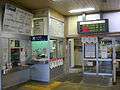 The ticket office and entrance
 The platforms
Adjacent stations
| « | Service | » | ||
|---|---|---|---|---|
| Sekishō Line | ||||
| Takinoue (K18) | - | Shimukappu (K21) | ||
| Sekishō Line Yūbari Branch | ||||
| Turminus | - | Numanosawa (Y21) | ||
History
The station opened on 1 November 1892 as Momijiyama Station (紅葉山駅).[1] It was renamed Shin-Yubari on 1 October 1981.[1] With the privatization of Japanese National Railways (JNR) on 1 April 1987, the station came under the control of JR Hokkaido.[1]
Surrounding area
- Momijiyama Post office
See also
References
| Wikimedia Commons has media related to Shin-Yūbari Station. |
Coordinates: 42°56′11.75″N 142°2′11.71″E / 42.9365972°N 142.0365861°E