Shillong
| Shillong | |
|---|---|
| Capital | |
|
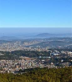
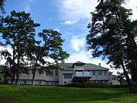
A view of Shillong | |
 Shillong  Shillong Location of Shillong in Meghalaya | |
| Coordinates: 25°34′00″N 91°53′00″E / 25.5667°N 91.8833°ECoordinates: 25°34′00″N 91°53′00″E / 25.5667°N 91.8833°E | |
| Country |
|
| State | Meghalaya |
| District | East Khasi Hills |
| Area | |
| • Capital | 64.36 km2 (24.85 sq mi) |
| Elevation | 1,525 m (5,003 ft) |
| Population (2011) | |
| • Capital | 143,229 |
| • Density | 234/km2 (610/sq mi) |
| • Metro | 354,325[1] |
| Languages | |
| • Official | Khasi (secondary English) |
| Time zone | IST (UTC+5:30) |
| PIN | 793 001 – 793 100 |
| Telephone code | 0364 |
| Vehicle registration | ML-05 |
| Climate | Cwb |
| Website |
eastkhasihills |

Shillong (English pronunciation: /ʃɪˈlɔːŋ/;[2][3] Khasi: Shillong) is the capital and hill station of Meghalaya, also known as "The Abode of Clouds", one of the smallest states in India. It is the headquarters of the East Khasi Hills district and is situated at an average altitude of 4,908 feet (1,496 m) above sea level, with the highest point being Shillong Peak at 6,449 feet (1,966 m). Shillong is the 330th most populous city in India with population of 143,007 according to the 2011 census.[4] It is said that the rolling hills around the town reminded the European settlers of Scotland. Hence, they would also refer to it as the "Scotland of the East".
Shillong has steadily grown in size since it was made the civil station of the Khasi and Jaintia Hills in 1864 by the British. In 1874, on the formation of Assam as the Chief Commissioner's Province, it was chosen as the headquarters of the new administration because of its convenient location between the Brahmaputra and Surma valleys and more so because the climate of Shillong was much cooler than tropical India. Shillong remained the capital of undivided Assam until the creation of the new state of Meghalaya on 21 January 1972, when Shillong became the capital of Meghalaya, and Assam moved its capital to Dispur in Guwahati. In 2016, it was voted "India's Favourite Hill Station" by HolidayIQ.com.[5]
Geography
Shillong is at 25°34′N 91°53′E / 25.57°N 91.88°E. It is on the Shillong Plateau, the only major uplifted structure in the northern Indian shield.[6] The city lies in the centre of the plateau and is surrounded by hills, three of which are revered in Khasi tradition: Lum Sohpetbneng, Lum Diengiei and Lum Shillong.
- Weather conditions: Pleasant, pollution-free; summers: The temperature varies from 23 °C (73 °F); winters: The temperature varies from 4 °C (39 °F).
- Location: Shillong, the capital city of Meghalaya is just 100 km (62 mi) from Guwahati which can be accessed by road along NH 40 , a journey of about 2 hours 30 minutes through lush green hills and the magnificent Umiam lake in between.
Climate
Under Köppen's climate classification the city features a subtropical highland climate (Cwb). Its summers are cool and very rainy, while its winters are cool and dry. Shillong is subject to vagaries of the monsoon. The monsoons arrive in June and it rains almost until the end of August. October–November and March–April are the best months to visit Shillong.
| Climate data for Shillong (1971–2000) | |||||||||||||
|---|---|---|---|---|---|---|---|---|---|---|---|---|---|
| Month | Jan | Feb | Mar | Apr | May | Jun | Jul | Aug | Sep | Oct | Nov | Dec | Year |
| Record high °C (°F) | 24.9 (76.8) |
26.1 (79) |
28.1 (82.6) |
30.2 (86.4) |
29.5 (85.1) |
29.5 (85.1) |
28.2 (82.8) |
28.4 (83.1) |
28.0 (82.4) |
27.8 (82) |
24.5 (76.1) |
22.5 (72.5) |
30.2 (86.4) |
| Average high °C (°F) | 14.6 (58.3) |
16.8 (62.2) |
21.0 (69.8) |
23.3 (73.9) |
23.3 (73.9) |
23.7 (74.7) |
23.7 (74.7) |
24.2 (75.6) |
23.2 (73.8) |
21.7 (71.1) |
19.1 (66.4) |
15.9 (60.6) |
20.8 (69.4) |
| Average low °C (°F) | 5.7 (42.3) |
7.2 (45) |
11.0 (51.8) |
13.9 (57) |
15.4 (59.7) |
17.4 (63.3) |
17.8 (64) |
17.6 (63.7) |
16.6 (61.9) |
14.2 (57.6) |
10.7 (51.3) |
7.1 (44.8) |
12.9 (55.2) |
| Record low °C (°F) | −0.9 (30.4) |
−2.4 (27.7) |
2.7 (36.9) |
6.6 (43.9) |
8.5 (47.3) |
10.0 (50) |
12.3 (54.1) |
10.0 (50) |
10.7 (51.3) |
6.7 (44.1) |
−0.5 (31.1) |
−3.3 (26.1) |
−3.3 (26.1) |
| Average rainfall mm (inches) | 12.5 (0.492) |
20.2 (0.795) |
42.4 (1.669) |
116.0 (4.567) |
266.1 (10.476) |
430.0 (16.929) |
461.7 (18.177) |
296.6 (11.677) |
289.6 (11.402) |
186.1 (7.327) |
30.1 (1.185) |
16.2 (0.638) |
2,167.4 (85.331) |
| Average rainy days | 1.4 | 2.2 | 3.7 | 9.0 | 16.3 | 17.9 | 18.2 | 16.1 | 15.9 | 8.4 | 2.4 | 1.3 | 112.7 |
| Source: India Meteorological Department (record high and low up to 2010)[7][8] | |||||||||||||
History
As the legend goes, Shillong was named after a boy called 'Aahlad', who was born to a virgin mother in a village near Bisi. This boy later became a handsome youth and was made the local deity; and the place was named after him.
Shillong was capital for composite Assam during the British regime and later till a separate State of Meghalaya was formed. David Scott, the British civil servant of the East India Company, was the Agent of the Governor-General North East Frontier. During the First Anglo-Burmese War the British authorities felt the need for a road to connect Sylhet and Assam.The route was to traverse across the Khasi and Jaintia Hills. David Scott overcame the difficulties his administration faced from the opposition of the Khasi Syiems — their chiefs and people. Impressed by the favorable cool climate of Khasi Hills, they negotiated with the Syiem of Cherra in 1829 for a sanatorium for the British. Thus began the consolidation of British interests in the Khasi-Jaintia Hills.
A serious uprising by the Khasis against foreign occupation of their land followed. It began early in 1829 and continued till January 1833. Eventually the Khasi confederate chiefs were no match against the military might of the British. David Scott negotiated for the surrender of the leader of the Khasi resistance, Tirot Sing, who was then taken to Dacca (present day Dhaka) for detention. After the resistance of the Khasis a political agent was posted in the hills, with its headquarters at Cherrapunjee. But the climatic condition and facilities of Cherrapunjee did not make the British happy, they then moved out to Shillong, which was then known as "Yeddo". The name "Shillong" was later adopted, as the location of the new town was below the Shillong Peak.
In 1874, a separate Chief Commissionership was formed with Shillong as the seat of administration. The new administration included Sylhet, now a part of Bangladesh. Also included in the Chief Commissionership were the Naga Hills (present day Nagaland), Lushai Hills (present day Mizoram) as well as Khasi, Jaintia and Garo Hills. Shillong was the capital of composite Assam till 1969 when the autonomous state of Meghalaya was formed. In January 1972 Meghalaya was made a full-fledged state.[9]
The Shillong Municipal Board has a long history dating back to 1878, when a proclamation was issued constituting Shillong and its suburbs, including the villages of Mawkhar and Laban, into a station under the Bengal Municipal Act of 1876. Inclusion of the villages of Mawkhar (S.E. Mawkhar, Jaiaw and part of Jhalupara and Mawprem) and Laban (Lumparing, Madan laban, Kench’s Trace and Rilbong) within the Municipality of Shillong was agreed to by Hain Manik Syiem of Mylliem under the agreement of 15 November 1878.[10] But, there is no trace of Shillong in the British era maps dating back to 1878, up to 1900.
Shillong was also the subject of the great earthquake that occurred on June 12, 1897. The earthquake had an estimated moment magnitude of 8.1. Twenty-seven lives from Shillong town alone were lost.[11]
Transport
Although well connected by road, Shillong has neither rail connections nor a proper air connection. Umroi Airport located 30 kilometres (19 mi) from the city center has only limited flights.
Roadways
Shillong is well connected by roads with all major northeastern states. Two major National Highways pass through:
- National Highway 40 (India) – Connected to Guwahati
- National Highway 44 (India) – Connected to Tripura & Mizoram (NH 44A)
Private bus operators as well as state transport buses from other states ply to and from Shillong daily. Taxi services are also available to destination like Guwahati, Agartala, Dimapur and other North Eastern towns and cities.
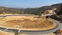
The Shillong Bypass (pictured) is a two lane road which stretches across 47.06 kilometres (29.2 mi) connecting Umiam (NH-40) to Jorabad (NH-44) which then leads to other North-Eastern Indian states of Mizoram and Tripura. The project estimated to have cost around ₹220.35 crore (US$33 million) was completed in a span of two years (2011-2013).[12][13]
Demographics
As of 2011 India census[14] Shillong City urban/metropolitan population is 354,325 of which 176,591 are males and 177,734 are females. Males constitute 46% of the population and females 54%. Average literacy rate of 86%, higher than the national average of 63.5%: male literacy is 85%, and female literacy is 92.34%. 13% of the population is under 6 years of age.
Khasis make up the majority of the population though the percentage of Khasi people in the city continues to fall as a result of the large number of migrants from other Indian states. The population of Khasis in Shillong is 5 lakhs making up 65.2 % of Shillong population at 2011 census. All the other North East tribes are represented here as well as significant numbers of Assamese, Bengali, and a bit of Nepali, Hindi-speaking people making it a fairly cosmopolitan city. Christianity is the dominant religion in the city, practised by 59.9 % of the Shillong population at 2011 census . Presbyterianism and other denominations of Protestants and Roman Catholics make up the Christian population. A large proportion of the population follow the original Khasi religion: Niam Khasi and Niamtre. Hinduism is also represented in significant numbers in the city forming about 30.0 % of Shillong's population at 2011 census .
Places of interest


These are locations in and around Shillong which are tourist spots.[15] These include:
- Elephant Falls: 12 km on the outskirts of the city, the mountain stream descends through two successive falls set in dells of fern covered rocks.
- Lady Hydari Park: The park stretches over a kilometre and has an adjacent mini zoo.
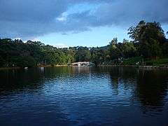
- Wards Lake: Known locally as Nan-Polok. It is an artificial lake with garden and boating facilities.
- Shillong Golf Course: Shillong has one of the largest golf courses (the world's wettest) in Asia: Gleneagles of the East. It enjoys the rare distinction of being one of the few natural golf courses in Asia. Not only is the Shillong Golf Course scenic and enjoyable, it is also challenging. A group of British civil service officers introduced golf to Shillong in 1898 by constructing a nine-hole course. The present 18-hole course was inaugurated in 1924. The course is set in a valley covered with pine and rhododendron trees. The tight fairways, carpeted with a local grass which hardens the soil, are difficult to negotiate. The number of out-of-bounds streams that criss-cross every fairway makes it all the more trying. Obstructions come in the form of bunkers, trees and rain. The longest hole is the 6th, which is a gruelling 594 yards. Shillong Golf Course is considered to be the "Glen Eagle of the East" at the United States Golf Association Museum. It was set in a valley at an altitude of 5200 ft in 1898 as a nine-hole course and later converted into an 18-hole course in 1924 by Captain Jackson and C. K. Rhodes.
- Motphran: The “Stone of France” which is locally known as "Motphran" was erected in memory of the 26th Khasi Labour Corps who served under the British in France during World War I. It bears the words of the famous Latin poet Horace "Dulce et decorum est pro patria mori" which can be roughly translated as "It is sweet and fitting to die for one's country."
- Shillong Peak: A picnic spot, 10 km from the city, 1965 m above sea level, offers a panoramic view of the scenic countryside and is the highest point in the state. Obeisance is paid to U Shulong at the sanctum sanctorum at the peak's summit every springtime, by the religious priest of Mylliem State.
- Capt. Williamson Sangma State Museum: For those interested in ethnic tribal culture and tradition this government museum offers insights to the lifestyle of the people. This museum is in the State Central Library complex where monuments for the great patriots of the state were erected besides the statue of Smt. Indira Gandhi and Netaji Subhash Chandra Bose.
- Don Bosco Centre for Indigenous Cultures: The Don Bosco Museum is part of DBCIC (Don Bosco Centre for Indigenous Cultures). DBCIC comprises research on cultures, publications, training, animation programmes and the museum, which is a place of knowledge-sharing on the cultures of the northeast in particular, and of culture in general. DBCIC with its Don Bosco Museum is situated at Mawlai, Shillong.
- Entomological Museum (Butterfly Museum): A privately owned museum of M/s Wankhar, Riatsamthiah, Shillong about 2 km from Police Bazar is the only known museum in India devoted to moths and butterflies.
- Air Force Museum at Upper Shillong
- Forest Museum in Lady Hydari Park
- Rhino Heritage Museum at Shillong
- Zoological Museum in Risa Colony
- Anthropological museum at Mawblei
- Botanical Museum at 4th Furlong
- Arunachal Museum at the Cantonment Area
- Chrysalis the Gallery: This art gallery is on the second floor of Salonsar Mansion at Police Bazaar, the commercial hub of Shillong. Chrysalis has flexible spacing to display paintings (canvases), sculpture, photography and handicrafts. Run by a local artist, Jaya Kalra, the gallery caters to exhibitions of artists and artisans especially from the northeast and also from the rest of India.
- State Museum: Located at the State Central Library complex.
- Cathedral of Mary Help of Christians is in Don Bosco Square.
- Bishop and Beadon Falls: Both cascade down the same escarpment into a deep valley.
- Spread Eagle Falls: 3 km from Polo Grounds.
- Sweet Falls: Sweet Falls (also called “Weitden,” in the native dialect) is the most beautiful of all the waterfalls in Shillong. It lies about 5 km from the Happy Valley and is about 96 m in height.
- Crinoline Falls: Near Lady Hydari Park.
Sports
Although relatively unknown in the field of sports, Shillong got into the limelight because of Shillong Lajong FC, a football club based here which has taken the Indian football scene by storm in the recent I-League. Jawaharlal Nehru Stadium is the homeground of Shillong Lajong FC and Royal Wahingdoh FC in I-League. It is the only capital city in Northeast India to produce two clubs that participate in the I-League, viz. Royal Wahingdoh FC and Shillong Lajong FC. Royal Wahingdoh FC was adjudged 2nd runners-up in the 2014-15 season of I-League.[16] Shillong Golf Course is one of the oldest golf course of the country and is surrounded by scenic pine and rhododendron trees.
Locals are adept in archery. Shillong is also famous for its daily dose of archery gambling where people predict scores of an archery game played near Polo Ground, Shillong.
Binningstar Lyngkhoi from Shillong is a national marathon runner and represented India in the last 2010 Commonwealth Games. He is the fastest marathoner in India with a timing of 2:18 hours.
Education
Shillong is fast emerging as an education hub for the entire northeastern region. Important educational institutes like the Indian Institute of Management, National Institute of Technology Meghalaya, University of Technology and Management, North Eastern Hill University (NEHU), Martin Luther Christian University, Institute of Hotel Management (IHM), National Institute of Fashion Technology, Shillong and North Eastern Indira Gandhi Regional Institute of Health and Medical Sciences, English and Foreign Languages University, Shillong College, St. Edmund's College, St. Anthony's College, Shillong and several others college and engineering institution have been established here.
Media
Local media in Shillong is strong. There are a number of theatres, newspapers, magazines, local radio and television stations. Shillong is also often called as "India's Rock Capital" due to its inhabitants' great passion for music.[17]
Cinema
Cinemas in Shillong include Bijou Cinema Hall, Payal Cinema, Gold Cinema and Anjalee Cinema Hall (also called Galleria Anjalee Cinema).[18]
Print media
Newspapers are published for Shillong both in Khasi and English. Prominent English dailies published here include Shillong Times, Meghalaya Guardian, Highland Post, Meghalaya Times and The Sentinel. Khasi dailies like Mawphor, Nongsain Hima among others are published here. Weekly newspaper are "Salonsar" and "Dongmusa". There are Magazines like "Iing Khristan" (celebrated 100 years of publication), "Pateng Mynta" in Khasi and "Youth Today" and "Eastern Panorama" in English.
Electronic media
The radio industry has expanded with a number of private and government-owned FM channels being introduced. State-owned Doordarshan transmits terrestrial television channels. Apart from these few weekly news channels like PCN, Ri Khasi Channel, Batesi and T7 are broadcast weekly on the local cable networks.
Communication services
Fixed telephones lines are available. Internet services are available both wired and wireless broadband. It is also well covered in mobile networks with all major cellular providers like Airtel, Aircel, Vodafone, IDEA, BSNL, Reliance are available here.
Headquarters Eastern Air Command, Indian Air Force
HQ Eastern Air Command (HQ, EAC) was shifted to Shillong on 10 Jun 63 from Kolkata and housed in the old buildings located at Nonglyer village at Upper Shillong, some 10 km from (Lower) Shillong, but at a greater altitude of around 6,000 feet AMSL. Initially a British military base, it was taken over by No 58 Gorkha Regiment of the Indian Army post independence in 1947. The Regiment was redeployed after the Sino-Indian War of 1962, making way for the IAF to step in. Only helicopters can operate from HQ, EAC, using a 12.7 hectare (31.3 acre) helipad.[19]
EAC controls air operations in the eastern sector which includes West Bengal, Assam, Mizoram and the other eastern states bordering Bangladesh, Burma and Tibet. EAC comprises permanent airbases at Chabua, Gauhati, Bagdogra, Barrackpore, Hashimara, Jorhat, Kalaikunda and Tezpur with forward airbases at Agartala, Culcutta, Panagarh and Shillong.[20]
Neighbourhoods
Notable personalities associated with Shillong
People who have been associated with Shillong include:
- Amita Malik, famous film critic.
- Anjum Hasan is a Bangalore-based writer from Shillong and her debut novel Lunatic in my Head which is set in Shillong was launched on 7 Dec 2007. She has also written a book of verse titled Street on the Hill.
- Anwaruddin Choudhury, a prominent naturalist who is known as the 'Birdman of Assam' was born and brought up in Shillong. He is the author of 19 books including The Birds of Assam.
- Arin Paul, filmmaker, spent his early days at Laitumkhrah, Shillong and was a product of St. Edmund's School, Shillong.
- Arthur Llewellyn Basham, noted historian of Indian culture. He died in Kolkata in 1986 and is buried in Shillong.
- Arundhati Roy, noted writer and Booker Prize winner, was born in the KJP Synnod Hospital in Shillong.
- Dr. A. P. J. Abdul Kalam, Former Indian President and Scientist, while delivering a lecture at Indian Institute of Management Shillong on 27 July 2015, Kalam suffered a massive heart attack at around 6:30 p.m IST. He was rushed to the Bethany Hospital in a critical condition, and subsequently died of cardiac arrest.[21]
- Edward Pritchard Gee, India's famous naturalist and author of the best seller The Wild Life of India spent his retired life in 'Evergreen cottage' in Upper Shillong. He left for England in 1968 and died soon after.
- Indira Goswami (Mamoni Goswami) spent her early days in Shillong and studied at Pine Mount School.
- John Shepherd-Barron, inventor of the automated teller machine (ATM) was born in Shillong.
- Karen David, a Canadian-British actress, singer and songwriter born in Shillong. She is best known for portraying "Princess Isabella Maria Lucia Elizabetta of Valencia" in ABC's fairytale-themed musical-comedy television series, Galavant, as well as Francesca "Cesca" Montoya in the BBC television series Waterloo Road, and Layla in the American action film The Scorpion King 2: Rise of a Warrior.
- Captain Keishing Clifford Nongrun, Kargil War Hero and a martyr hails from this city.
- Leela Majumdar, the writer, spent her childhood days at Shillong, where she studied at Loreto Convent.
- Nirad C. Chaudhuri has written extensively about Shillong in his book The Autobiography of an Unknown Indian.
- Queenie Rynjah, Padmashree and educationist
- Rabindranath Tagore, Nobel laureate, poet, author, thinker, artist, playwright, considered a patriarch of Bengali society, often sojourned in the cool climes of Shillong; besides living in a summer residence called Mitali, (today in use as a temporary State Legislative Assembly on loan from the State Art and Culture Department). A writing desk and chair used by the Poet Laureate can still be seen (and used) in the Maharaja Suite of the Tripura Castle Heritage Hotel;
- Rono Dutta, president of United Airlines did his schooling from St. Edmunds School .
- Rose Millian Bathew(Kharbuli) (b 1931) was the first woman chairperson of the Union Public Service Commission. She is from Shillong and lives there now.
- Shillong Chamber Choir: Internationally acclaimed choir group Shillong Chamber Choir is also from Shillong. They have performed in the World Choir Olympics and elsewhere in the world. They won the talent show India's Got Talent in 2010.
- Swami Vivekananda (12 January 1863 – 4 July 1902), born as Narendranath Dutta, was the chief disciple of the 19th century mystic Sri Sri Ramakrishna Paramahamsa and is the founder of Ramakrishna Mission headquartered at Belur. He was primarily responsible for introducing Hindu philosophies of Vedanta and Yoga in the West and best known for his inspiring speech beginning with "Sisters and Brothers of America”, in his opening remark at the Parliament of the World's Religions at Chicago in 1893. The Swami delivered his last public lecture of his life in Shillong. The place of his last public lecture have been immortalised by erecting his statue at the very spot (also known as Quinton Memorial/Vivekananda Cultural Centre).
- Swami Bhaskarananda Head of the Vedanta Center of Western Washington hails from Shillong. The center has enjoyed considerable growth under his stewardship. He has authored several books on Vedanta.
- Utpal Dutt, the prominent actor of Bengali and Hindi cinema, studied initially in St. Edmund's School before moving to St.Xavier's Collegiate School Kolkata.[22]
- Victor Bannerjee, an actor, was a student of St. Edmund's School.
- Zohurul Hoque, translator of the Holy Quran into Bengali, Assamese and English was a student at St. Edmund's College.
See also
References
- ↑ "Shillong City Overwiew". Retrieved 11 May 2014.
- ↑ "Define Shillong". Dictionary.com. Retrieved 31 October 2013.
- ↑ "Definition of Shillong". The Free Dictionary. Retrieved 31 October 2013.
- ↑ http://www.census2011.co.in/city.php
- ↑ (Press release) (March 31, 2016). "Shillong voted as 'India's favourite hill station'". The Shillong Times. Retrieved March 31, 2016.
- ↑ Bilham, R. and P. England, Plateau pop-up during the great 1897 Assam earthquake. Nature(Lond),410, 806–809, 2001
- ↑ "Shillong Climatological Table Period: 1971–2000". India Meteorological Department. Retrieved April 20, 2015.
- ↑ "Ever recorded Maximum and minimum temperatures up to 2010". India Meteorological Department. Archived from the original on 21 May 2013. Retrieved April 20, 2015.
- ↑ Syiemlieh, David R. (2005). Reflections From Shillong: Speeches Of M.M. Jacob (Volume 3). Daya Books. ISBN 8189233297.
- ↑ "Shillong Municipal Board - History". Shillong Municipal Board. Retrieved 21 May 2014.
- ↑ Jugal Kalita (June 15, 2014). "The Great Assam Earthquake of 1897".
- ↑ "Gadkari to inaugurate Shillong Bypass". The Economic Times. (The Times Group). April 30, 2015. Retrieved May 1, 2015.
- ↑ ANI (May 1, 2015). "Gadkari to inaugurate Shillong bypass today". Yahoo! News. (Yahoo!). Retrieved May 1, 2015.
- ↑ "Census of India 2001: Data from the 2001 Census, including cities, villages and towns (Provisional)". Census Commission of India. Archived from the original on 2004-06-16. Retrieved 2008-11-01.
- ↑ Hattar, Rahul Singh. "Shillong: Scotland of the East". The Indian Backpacker. Retrieved 8 October 2011.
- ↑ http://i-league.org/matchday/points-table/
- ↑ Mohar Basu (February 20, 2015). "Rock On 2 to be shot in Shillong". The Times of India. Retrieved May 10, 2015.
- ↑ "Shillong gets its first multiplex". The Shillong Times. January 30, 2015. Retrieved April 4, 2015.
- ↑ http://indianairforce.nic.in/show_command.php?pg_id=22&page_type=command&comm_id=1
- ↑ http://www.bharat-rakshak.com/IAF/Units/Commands/295-Eastern-Air-Command.html
- ↑ http://www.ndtv.com/india-news/former-president-apj-abdul-kalam-admitted-to-icu-in-shillong-sources-1201111
- ↑ Utpal Dutt Wikipedia
External links
| Wikimedia Commons has media related to Shillong. |
| Wikiquote has quotations related to: Shillong |
 Shillong travel guide from Wikivoyage
- Eastern Panorama – Oldest Magazine of North East India
- Meghalaya State Government Portal
- Shillong.com
- Shillong Online
- Resubelpara
- The Shillong Times – North East India Second Oldest English Daily
- Online news in Khasi
- Don Bosco Museum - Don Bosco Centre for Indigenous Cultures
| Districts | |
|---|---|
| Municipalities | |
| Other | |
| |