Sheepwash Channel Railway Bridge
| Sheepwash Channel Railway Bridge | |
|---|---|
 The Sheepwash Channel Railway Bridge with the old Rewley Road Swing Bridge in the foreground, on the Sheepwash Channel. | |
| Coordinates | 51°45′20″N 1°16′15″W / 51.755586°N 1.270946°WCoordinates: 51°45′20″N 1°16′15″W / 51.755586°N 1.270946°W |
| Carries | Cherwell Valley Line |
| Crosses | Sheepwash Channel |
| Locale | Oxford, England |
| Maintained by | Network Rail |
| Characteristics | |
| Design | Girder bridge |
| Material | Steel |
| Number of spans | 1 |
Sheepwash Channel Railway Bridge is a railway bridge over Sheepwash Channel in west Oxford, England, just north of Oxford railway station.[1] To the north are Cripley Meadow and Fiddler's Island. To the south are Osney Island and the Botley Road.
Railways around Oxford | |||||||||||||||||||||||||||||||||||||||||||||||||||||||||||||||||||||||||||||||||||||||||||||||||||||||||||||||||||||||||||||||||||||||||||||||||||||||||||||||||||||||||||||||||||||||||||||||
|---|---|---|---|---|---|---|---|---|---|---|---|---|---|---|---|---|---|---|---|---|---|---|---|---|---|---|---|---|---|---|---|---|---|---|---|---|---|---|---|---|---|---|---|---|---|---|---|---|---|---|---|---|---|---|---|---|---|---|---|---|---|---|---|---|---|---|---|---|---|---|---|---|---|---|---|---|---|---|---|---|---|---|---|---|---|---|---|---|---|---|---|---|---|---|---|---|---|---|---|---|---|---|---|---|---|---|---|---|---|---|---|---|---|---|---|---|---|---|---|---|---|---|---|---|---|---|---|---|---|---|---|---|---|---|---|---|---|---|---|---|---|---|---|---|---|---|---|---|---|---|---|---|---|---|---|---|---|---|---|---|---|---|---|---|---|---|---|---|---|---|---|---|---|---|---|---|---|---|---|---|---|---|---|---|---|---|---|---|---|---|---|
Legend
| |||||||||||||||||||||||||||||||||||||||||||||||||||||||||||||||||||||||||||||||||||||||||||||||||||||||||||||||||||||||||||||||||||||||||||||||||||||||||||||||||||||||||||||||||||||||||||||||
The bridge is close to Rewley Road Swing Bridge just to the east,[2] an older and now disused swing bridge for the former Buckinghamshire Railway line of London and North Western Railway that used to serve the Oxford Rewley Road railway station.[3] It is also close to Rewley Road Bridge to the east.[1] Sheepwash channel links the River Thames with the Oxford Canal via Castle Mill Stream and Isis Lock.
Gallery
 View of the Sheepwash Channel Railway Bridge in the background and the site of the old Rewley Road Swing Bridge in the foreground.
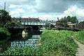 The Sheepwash Channel with the new railway bridge and the old railway swing bridge.
 Looking north along the railway line from Oxford railway station over Sheepwash Channel Railway Bridge towards Cripley Meadow.
References
- 1 2 "Sheepwash Channel Railway Bridge". UK: CanalPlanAC. Retrieved 19 September 2012. External link in
|publisher=(help) - ↑ Woolley, Liz (2012). Oxford's Working Past. Huxley Scientific Press. pp. 6, 13–14. ISBN 978-0-9522671-7-1. External link in
|publisher=(help) - ↑ "Sheepwash Channel — Oxford Canal / River Thames". UK: Movable Bridges in the British Isles. Retrieved 15 September 2012. External link in
|publisher=(help)
This article is issued from Wikipedia - version of the 3/23/2015. The text is available under the Creative Commons Attribution/Share Alike but additional terms may apply for the media files.