Shady Lane, Indiana
| Shady Lane | |
|---|---|
| Unincorporated community | |
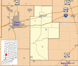 Shady Lane Location in Clay County | |
| Coordinates: 39°32′44″N 87°08′01″W / 39.54556°N 87.13361°WCoordinates: 39°32′44″N 87°08′01″W / 39.54556°N 87.13361°W | |
| Country | United States |
| State | Indiana |
| County | Clay |
| Township | Brazil |
| Elevation | 653 ft (199 m) |
| GNIS feature ID | 443250[1] |
Shady Lane is an unincorporated community in Brazil Township, Clay County, Indiana. It is part of the Terre Haute Metropolitan Statistical Area.
Shady Lane was named from its tree-lined streets.[2]
Geography
Shady Lane is located at 39°32′44″N 87°08′01″W / 39.54556°N 87.13361°W.
References
- ↑ "Shady Lane, Indiana". Geographic Names Information System. United States Geological Survey. Retrieved 2010-08-20.
- ↑ Baker, Ronald L. (October 1995). From Needmore to Prosperity: Hoosier Place Names in Folklore and History. Indiana University Press. p. 298. ISBN 978-0-253-32866-3.
...name from the rows of sycamore trees...
Municipalities and communities of Clay County, Indiana, United States | ||
|---|---|---|
| City | ||
| Towns | ||
| Townships | ||
| CDP | ||
| Other unincorporated communities |
| |
| Ghost towns | ||
| Footnotes | ‡This populated place also has portions in an adjacent county or counties | |
This article is issued from Wikipedia - version of the 10/26/2016. The text is available under the Creative Commons Attribution/Share Alike but additional terms may apply for the media files.