Senneterre, Quebec
| Senneterre | |
|---|---|
| City | |
 | |
|
Motto: Saine terre attire ("Healthy land attracts") | |
_Quebec_location_diagram.png) Location within La Vallée-de-l'Or RCM. | |
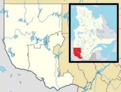 Senneterre Location in western Quebec. | |
| Coordinates: 48°23′N 77°14′W / 48.383°N 77.233°WCoordinates: 48°23′N 77°14′W / 48.383°N 77.233°W[1] | |
| Country |
|
| Province |
|
| Region | Abitibi-Témiscamingue |
| RCM | La Vallée-de-l'Or |
| Settled | 1904 |
| Constituted | June 13, 1919 |
| Government[2] | |
| • Mayor | Jean-Maurice Matte |
| • Federal riding |
Abitibi—Baie-James— Nunavik—Eeyou |
| • Prov. riding | Abitibi-Est |
| Area[2][3] | |
| • Total | 16,323.70 km2 (6,302.62 sq mi) |
| • Land | 14,892.00 km2 (5,749.83 sq mi) |
| Population (2011)[3] | |
| • Total | 2,953 |
| • Density | 0.2/km2 (0.5/sq mi) |
| • Pop 2006-2011 |
|
| • Dwellings | 1,418 |
| Time zone | EST (UTC−5) |
| • Summer (DST) | EDT (UTC−4) |
| Postal code(s) | J0Y 2M0 |
| Area code(s) | 819 |
| Highways |
|
| Website |
www senneterre |
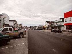
Senneterre is a town in the Abitibi-Témiscamingue region of northwestern Quebec, Canada. It is in the Vallée-de-l'Or Regional County Municipality. The town's territory includes a vast undeveloped area stretching from the Bell River to the Mauricie region. The town centre itself (48°23′30″N 77°14′20″W / 48.39167°N 77.23889°W) is about 60 kilometres (37 mi) northeast of Val-d'Or on the banks of the Bell River, at the intersection of the Canadian National Railway and Quebec Route 113.
There are three schools in this city: St-Paul elementary school, Chanoine-Delisle elementary school and La Concorde High school. This town centre is mainly surrounded by Parent Lake and Tiblemont Lake. The main street of this city is called 10th Avenue. The arena is named Centre sportif André Dubé. The economy of this city is mainly based on wood exploitation.
History
While the site first served as a trading post, real colonization began in 1904 when the first permanent settlers arrived. It was first identified as Rivière-Nottaway, then Rivière-Bell. Over the next 10 years, there were only a few residents who were joined by people fleeing conscription. Between 1911 and 1913 when the National Transcontinental Railway was being constructed, the area was surveyed and the geographic township of Senneterre was formed, named in honour of a captain of the Languedoc Regiment that fought in the Battle of Sainte-Foy.[1][4]
The completion of the railroad accelerated the development of the place. In 1914, the Parish of Saint-Paul-de-Senneterre was founded, and in 1919, the place was incorporated as the Township Municipality of Senneterre-Partie-Ouest, named after the township and its relative position therein. It developed into a center for forestry, commerce and tourism.[1]
In 1948, it shortened its name to Senneterre and changed status to village municipality, while gaining town status in 1956. In 1953, CFS Senneterre opened, home to the No. 34 Aircraft Control & Warning Squadron and part of the Pinetree Line chain of radar stations. After the closure of CFS Val-d'Or in 1976, the base also served as the Search and Rescue centre for north-western Quebec. In 1988, CFS Senneterre was closed.[1][5]
On July 6, 1996, the Town of Senneterre was greatly expanded from 114.45 square kilometres (44.19 sq mi) to 14,887.03 square kilometres (5,747.91 sq mi) when the unorganized territories of Lac-Quentin and Lac-Mingo and almost all of the unorganized territories of Matchi-Manitou and Lac-Bricault were added to its jurisdiction. From that day until La Tuque's amalgamation in 2002, it was in terms of area the second largest incorporated entity in Quebec after Baie-James and the largest with town status in Quebec.[1]
City council
- Mayor: Jean-Maurice Matte
- Councillors: Louise Allaire-Boucher, Carole Chantal, Sylvie Des Roberts, André Lévesque, René Paquin, Simon Roy [2]
Communities
In addition to Senneterre itself, the town's territory also includes the following hamlets or rail stops, all located along the Canadian National Railway:
- Forsyth (48°14′14″N 76°25′40″W / 48.23722°N 76.42778°W)
- Gagnon-Siding (48°15′12″N 76°08′45″W / 48.25333°N 76.14583°W)
- Langlade (48°13′50″N 75°58′25″W / 48.23056°N 75.97361°W)
- Monet (48°10′06″N 75°38′36″W / 48.16833°N 75.64333°W)
- Paradis (48°13′33″N 76°35′14″W / 48.22583°N 76.58722°W)
- Press (48°14′35″N 76°43′57″W / 48.24306°N 76.73250°W)
Demographics
According to the Canada 2006 Census:[6]
- Population: 2,993
- % Change (2001-2006): -8.6
- Area (km²): 14,887.03
- Density (persons per km²): 0.2
- Private dwellings occupied by usual residents: 1332 (total dwellings: 1418)
- Mother tongue:
- English as first language: 0.5%
- French as first language: 95.2%
- English and French as first language: 0.9%
- Other as first language: 3.4%
Population trend:[7]
- Population in 2011: 2953 (2006 to 2011 population change: -1.3 %)
- Population in 2006: 2993
- Population in 2001: 3275
- Population total in 1996: 3535
- Senneterre (ville): 3488
- Matchi-Manitou (Unorganized): 241
- Population in 1991:
- Senneterre (ville): 3563
- Matchi-Manitou (Unorganized): 240
References
- 1 2 3 4 5 "Senneterre (ville)" (in French). Commission de toponymie du Québec. Retrieved 2011-01-13.
- 1 2 3 "Senneterre". Répertoire des municipalités (in French). Ministère des Affaires municipales, des Régions et de l'Occupation du territoire. Retrieved 2011-01-13.
- 1 2 "Senneterre census profile". 2011 Census data. Statistics Canada. Retrieved 2011-01-13.
- ↑ "Senneterre (canton)" (in French). Commission de toponymie du Québec. Retrieved 2011-01-14.
- ↑ Bruce Forsyth. "A Short History of Abandoned and Downsized Canadian Military Bases - Introduction". Military Bruce Historical Writings. Retrieved 2011-01-14.
- ↑ "Senneterre community profile". 2006 Census data. Statistics Canada. Retrieved 2011-01-13.
- ↑ Statistics Canada: 1996, 2001, 2006, 2011 census
External links
- Ville de Senneterre (French)
 |
Baie-James | | ||
| Lac-Despinassy Senneterre (parish) Val-d'Or |
|
La Tuque | ||
| ||||
| | ||||
| Matchi-Manitou, Lac-Metei, Réservoir-Dozois | Lac-Pythonga, Lac-Lenôtre, Lac-Moselle, Dépôt-Échouani |
| Cities | |
|---|---|
| Municipalities | |
| Parishes | |
| Unorganized territories | |
| |