Washington State Route 300
| ||||
|---|---|---|---|---|
|
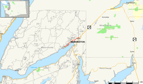
Map of Mason County in western Washington with SR 300 highlighted in red | ||||
| Route information | ||||
| Auxiliary route of SR 3 | ||||
| Defined by RCW 47.17.540 | ||||
| Maintained by WSDOT | ||||
| Length: | 3.35 mi[1] (5.39 km) | |||
| Existed: | 1964[2] – present | |||
| Major junctions | ||||
| West end: |
| |||
| East end: |
| |||
| Location | ||||
| Counties: | Mason | |||
| Highway system | ||||
| ||||

State Route 300 (SR 300) is a short state highway in Mason County, in the U.S. state of Washington. It extends 3.35 miles (5.39 km) from Belfair State Park to SR 3 in the community of Belfair. The route serves as a connector from Belfair State Park to Belfair and SR 3. The highway was Secondary State Highway 21C (SSH 21C) from 1957 until 1964.
Route description
SR 300 runs 3.35 miles (5.39 km) from Belfair State Park to SR 3 in the community of Belfair. The route serves as a connector from Belfair State Park to Belfair and SR 3.[3][4] WSDOT has found that more than 11,000 motorists utilize the road daily before the interchange with SR 3 based on average annual daily traffic (AADT) data.[5] SR 300 starts at the entrance to Belfair State Park west of Belfair. From the state park, the highway goes northeast along the coastline of the Hood Canal to Belfair, and turns south to merge onto SR 3.[3][6]
History

When the Primary and Secondary Highways were realigned in 1957, the current SR 300 became Secondary State Highway 21C (SSH 21C).[7] SSH 21C became SR 300 in 1964 during the 1964 highway renumbering, in which the Washington State Department of Transportation (WSDOT) replaced the previous system of Primary and Secondary Highways with a new system called State Routes, which is still in use today.[8][9]
Major intersections
The entire route is in Mason County.
| Location | mi[1] | km | Destinations | Notes | |
|---|---|---|---|---|---|
| | 0.00 | 0.00 | |||
| Belfair | 3.18 | 5.12 | Old Belfair Highway and NE Clifton Lane | Route turns south here (unsigned; signage on SB SR 3 near Clifton Lane is incorrect) | |
| 3.35 | 5.39 | ||||
| 1.000 mi = 1.609 km; 1.000 km = 0.621 mi | |||||
References
- 1 2 Washington State Department of Transportation. "State Highway Log, 2006" (pdf). Retrieved November 10, 2008.
- ↑ Washington State Legislature. "RCW 47.17.540: State Route 300". Retrieved November 10, 2008.
- 1 2 Google (November 20, 2015). "State Route 300 Map" (Map). Google Maps. Google. Retrieved November 20, 2015.
- ↑ The Road Atlas (Map). Rand McNally. 2008. p. 108. ISBN 0-528-93961-0.
- ↑ Washington State Department of Transportation (2007). "Washington Annual Average Daily Traffic Data" (PDF). Retrieved November 10, 2008.
- ↑ Official State Highway Map (PDF) (Map) (2008-2009 ed.). 1:842,000. Official State Highway Maps. Cartography by U.S. Geological Survey. Olympia, Washington: Washington State Department of Transportation. 2008. § E3. Retrieved November 10, 2008.
- ↑ Washington State Legislature (1957). "172". Session Laws of the State of Washington. Session Laws of the State of Washington (1957 ed.). Olympia, Washington: Washington State Legislature. Retrieved November 10, 2008.
- ↑ C. G. Prahl, Washington State Highway Commission (December 1, 1965). "Identification of State Highways, Part 1" (PDF).
- ↑ C. G. Prahl, Washington State Highway Commission (December 1, 1965). "Identification of State Highways, Part 2" (PDF).
External links
| ||