Scott County, Missouri
| Scott County, Missouri | |
|---|---|
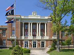 Scott County courthouse in Benton | |
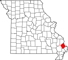 Location in the U.S. state of Missouri | |
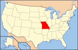 Missouri's location in the U.S. | |
| Founded | December 28, 1821 |
| Named for | John Scott |
| Seat | Benton |
| Largest city | Sikeston |
| Area | |
| • Total | 426 sq mi (1,103 km2) |
| • Land | 420 sq mi (1,088 km2) |
| • Water | 5.9 sq mi (15 km2), 1.4% |
| Population (est.) | |
| • (2015) | 39,008 |
| • Density | 93/sq mi (36/km²) |
| Congressional district | 8th |
| Time zone | Central: UTC-6/-5 |
| Website |
www |
Scott County is a county located in the southeastern portion of the U.S. state of Missouri. As of the 2010 census, the population was 39,191.[1] Its county seat is Benton.[2] The county was organized in 1821 and named for U.S. Representative John Scott, the first federal representative from Missouri.
Scott County comprises the Sikeston, MO Micropolitan Statistical Area, which is also included in the Cape Girardeau-Sikeston, MO-IL Combined Statistical Area.
The county is home to Scott County Central High School, which has won 18 state championships in boys basketball—the most of any high school in the state.
History
This area along the Mississippi River was long occupied by indigenous peoples. In historic times, the large and powerful Osage people dominated a large territory including this area and up and west from the later St. Louis, Missouri. Cape St. Croix, a rock island in the Mississippi River, has a cross erected by Jesuit missionary Father De Montigny, who traveled with early French explorers in 1599. Some French colonists established trading relationships with the Osage; the traders were based in St. Louis, founded in the late 18th century.
Spain had taken control in 1763 after French lost to Britain in the Seven Years' War. They laid out the King’s Highway (El Camino Real) in 1789, a north-south route crossing the county and extending through St. Louis, Missouri. In the late 1790s, Southerners were the first United States settlers on Spanish land grants in this area. France briefly took back the territory, then sold it to the United States in 1803 as part of the Louisiana Purchase.
Delaware (Lenape) and Shawnee people migrated into the area in the 1820s from territories east of the Mississippi, pushed by European-American encroachment on their lands.
The second county formed in Missouri’s Southeast Lowland Region, Scott County was created by the Missouri state legislature on December 28, 1821. The county was named in honor of John Scott (1785–1861), the first congressman from Missouri.[3]
One of the earliest settlements was Commerce, Missouri, long known as Tywapitty, derived from an Osage language term. It was an early French fur trading post. Under Spanish rule before 1800, Rezin Bowie was syndic of Tywappity Settlement. (He was the brother of Kentucky frontiersman Jim Bowie.) This was established as a river landing by 1803, and residents formed the first Baptist Church in Missouri here in 1805. The city was platted in 1823. It served as the Scott county seat from 1864–1878.
The current county seat of Benton was laid out in 1822; it is named after Thomas Hart Benton, one of Missouri’s first U.S. Senators.
New Hamburg, the third town founded in the county, was settled by a wave of German immigrants in the late 1840s, who came to this country after the German revolutions of 1848. The first log church was St. Lawrence Catholic Church. Sikeston, the largest city in the county and the fourth settlement to be founded, was settled in 1800 and was laid out in 1860 by John Sikes on the Cairo & Fulton Railroad.
The county was devastated by guerrilla raids during the U.S. Civil War. Afterward, it developed rapidly from the 1870s to the early 1900s; its dense forests were lumbered off and numerous railroads were constructed. Towns founded during this period included Diehlstadt, Morley, Oran, Perkins, Blodgett, Crowder, Vanduser, Illmo, Fornfelt (Scott City), Chaffee, Ancell, and Kelso. The Thebes-Mississippi River Railroad Bridge at Illmo was built in 1905.
Located near Morley is the gravesite of Nathaniel W. Watkins, a state legislator and a general in the Missouri State Guards. He was a half-brother of statesman Henry Clay. Wilson Brown, the ninth lieutenant governor of Missouri, lived in the county for a time. Noted early legislators such as Joseph Hunter II and Abraham Hunton also lived here.
Cotton, soybeans, melon and grains were all common crops in rural Scott County. Between the Mississippi River and Little River District drainage ditches lies one of the oldest drainage systems in the United States, Crowley’s Ridge, established in 1905, is a remnant of an old coastal floodplain and natural levee that crosses the country.
On January 28, 2004, the Scott County Courthouse was added to the National Register of Historic Places.
Geography
According to the U.S. Census Bureau, the county has a total area of 426 square miles (1,100 km2), of which 420 square miles (1,100 km2) is land and 5.9 square miles (15 km2) (1.4%) is water.[4] The county's eastern border with Illinois is formed by the Mississippi River.
Adjacent counties
- Cape Girardeau County (northwest)
- Alexander County, Illinois (northeast)
- Mississippi County (southeast)
- New Madrid County (south)
- Stoddard County (southwest)
Major highways
Demographics
| Historical population | |||
|---|---|---|---|
| Census | Pop. | %± | |
| 1830 | 2,136 | — | |
| 1840 | 5,974 | 179.7% | |
| 1850 | 3,182 | −46.7% | |
| 1860 | 5,247 | 64.9% | |
| 1870 | 7,317 | 39.5% | |
| 1880 | 8,587 | 17.4% | |
| 1890 | 11,228 | 30.8% | |
| 1900 | 13,092 | 16.6% | |
| 1910 | 22,372 | 70.9% | |
| 1920 | 23,409 | 4.6% | |
| 1930 | 24,913 | 6.4% | |
| 1940 | 30,377 | 21.9% | |
| 1950 | 32,842 | 8.1% | |
| 1960 | 32,748 | −0.3% | |
| 1970 | 33,250 | 1.5% | |
| 1980 | 39,647 | 19.2% | |
| 1990 | 39,376 | −0.7% | |
| 2000 | 40,422 | 2.7% | |
| 2010 | 39,191 | −3.0% | |
| Est. 2015 | 39,008 | [5] | −0.5% |
| U.S. Decennial Census[6] 1790-1960[7] 1900-1990[8] 1990-2000[9] 2010-2015[1] | |||
As of the census[10] of 2000, there were 40,422 people, 15,626 households, and 11,219 families residing in the county. The population density was 37/km² (96/mi²). There were 16,951 housing units at an average density of 16/km² (40/mi²). The racial makeup of the county was 87.68% White, 10.50% Black or African American, 0.28% Native American, 0.23% Asian, 0.01% Pacific Islander, 0.40% from other races, and 0.90% from two or more races. Approximately 1.11% of the population were Hispanic or Latino of any race.
There were 15,626 households out of which 35.40% had children under the age of 18 living with them, 54.60% were married couples living together, 13.40% had a female householder with no husband present, and 28.20% were non-families. 25.00% of all households were made up of individuals and 11.80% had someone living alone who was 65 years of age or older. The average household size was 2.55 and the average family size was 3.03.
In the county the population was spread out with 27.40% under the age of 18, 8.50% from 18 to 24, 27.50% from 25 to 44, 22.90% from 45 to 64, and 13.70% who were 65 years of age or older. The median age was 36 years. For every 100 females there were 91.60 males. For every 100 females age 18 and over, there were 86.40 males.
The median income for a household in the county was $39,735, and the median income for a family was $48,847. Males had a median income of $30,169 versus $19,269 for females. The per capita income for the county was $19,363. About 12.30% of families and 16.10% of the population were below the poverty line, including 23.50% of those under age 18 and 13.60% of those age 65 or over.
Religion
According to the Association of Religion Data Archives County Membership Report (2000), Scott County is a part of the Bible Belt with evangelical Protestantism being the majority religion. The most predominant denominations among residents in Scott County who adhere to a religion are Southern Baptists (40.54%), Roman Catholics (27.12%), and Methodists (9.28%).
Politics
Local
The Democratic Party completely controls politics at the local level in Scott County. Democrats hold every elected position in the county.[11]
| Scott County, Missouri | ||||
|---|---|---|---|---|
| Elected countywide officials | ||||
| Assessor | Teresa Houchin | Democratic | ||
| Circuit Clerk | Christy Hency | Democratic | ||
| County Clerk | Rita Milam | Democratic | ||
| Collector | Mark Hensley | Democratic | ||
| Commissioner (Presiding) |
Jamie Burger | Democratic | ||
| Commissioner (District 1) |
Dennis Ziegenhorn | Democratic | ||
| Commissioner (District 2) |
Donnie Kiefer | Democratic | ||
| Coroner | Scott C. Amick | Democratic | ||
| Prosecuting Attorney | Paul R. Boyd | Democratic | ||
| Public Administrator | Pam Dirnberger | Democratic | ||
| Recorder | Tara Mason | Democratic | ||
| Sheriff | Rick Walter | Democratic | ||
| Surveyor | Brian Strickland | Democratic | ||
| Treasurer | Glenda Enderle | Democratic | ||
State
Scott County is divided into three legislative districts in the Missouri House of Representatives.
| Year | Republican | Democratic | Third Parties |
|---|---|---|---|
| 2012 | 49.99% 8,421 | 48.04% 8,092 | 1.98% 333 |
| 2008 | 53.12% 9,494 | 45.55% 8,142 | 1.33% 238 |
| 2004 | 58.69% 10,198 | 40.31% 7,004 | 1.00% 174 |
| 2000 | 52.12% 8,159 | 46.59% 7,293 | 1.29% 202 |
| 1996 | 38.71% 5,878 | 59.76% 9,074 | 1.53% 233 |
| 1992 | 47.32% 7,564 | 52.68% 8,422 | 0.00% 0 |
| 1988 | 56.49% 7,845 | 43.45% 6,035 | 0.06% 8 |
| 1984 | 59.90% 8,446 | 40.10% 5,654 | 0.00% 0 |
| 1980 | 49.80% 7,619 | 50.13% 7,669 | 0.07% 11 |
| 1976 | 41.63% 5,558 | 58.37% 7,793 | 0.01% 1 |
Federal
Scott County is included in Missouri’s 8th Congressional District and is currently represented by Jason T. Smith (R-Salem) in the U.S. House of Representatives.
7614| Party | Candidate | Votes | % | ± | |
|---|---|---|---|---|---|
| Republican | Jason T. Smith* | 5,305 | 69.67 | ||
| Democratic | Barbara Stocker | 1,755 | 23.05 | ||
| Libertarian | Rick Vandeven | 294 | 3.86 | ||
| Independent | Terry Hampton | 145 | 1.90 | ||
| Constitution | Doug Enyart | 115 | 1.51 | ||
| Community | Mitt Romney | % | Barack Obama | % | Gary Johnson | % | Virgil H. Goode, Jr. | % | % | Total |
|---|---|---|---|---|---|---|---|---|---|---|
| Benton | 846 | 75.94% | 244 | 21.90% | 21 | 1.89% | 3 | 0.27% | R+ 54.04% | 1,114 |
| Blodgett | 781 | 81.61% | 164 | 17.14% | 9 | 0.94% | 3 | 0.31% | R+ 64.47% | 957 |
| Chaffee | 999 | 67.87% | 439 | 29.82% | 30 | 2.04% | 4 | 0.27% | R+ 38.05% | 1,472 |
| Commerce | 214 | 64.26% | 107 | 32.13% | 12 | 3.60% | 0 | 0.00% | R+ 32.13% | 333 |
| Diehlstadt | 135 | 75.84% | 42 | 23.60% | 0 | 0.00% | 1 | 0.56% | R+ 52.24% | 178 |
| Haywood City | 9 | 9.28% | 88 | 90.72% | 0 | 0.00% | 0 | 0.00% | D+ 81.44% | 97 |
| Kelso | 635 | 79.18% | 156 | 19.45% | 11 | 1.37% | 0 | 0.00% | R+ 59.73% | 802 |
| McMullin | 76 | 84.44% | 14 | 15.56% | 0 | 0.00% | 0 | 0.00% | R+ 68.88% | 90 |
| Miner | 763 | 77.86% | 201 | 20.51% | 12 | 1.22% | 4 | 0.41% | R+ 57.35% | 980 |
| Morley | 284 | 65.59% | 137 | 31.64% | 8 | 1.85% | 4 | 0.92% | R+ 33.95% | 433 |
| New Hamburg | 286 | 80.56% | 62 | 17.46% | 3 | 0.85% | 4 | 1.13% | R+ 63.10% | 355 |
| Oran | 701 | 77.98% | 183 | 20.36% | 12 | 1.34% | 3 | 0.33% | R+ 57.62% | 899 |
| Perkins | 56 | 61.54% | 33 | 36.26% | 2 | 2.20% | 0 | 0.00% | R+ 25.28% | 91 |
| Scott City | 1,329 | 68.15% | 581 | 29.80% | 39 | 2.00% | 1 | 0.05% | R+ 38.35% | 1,950 |
| Sikeston | 3,676 | 60.31% | 2,360 | 38.72% | 52 | 0.85% | 7 | 0.12% | R+ 21.59% | 6,095 |
| Vanduser | 136 | 75.14% | 45 | 24.86% | 0 | 0.00% | 0 | 0.00% | R+ 50.28% | 181 |
| Absentees | 697 | 71.71% | 266 | 27.37% | 8 | 0.82% | 1 | 0.10% | R+ 44.34% | 972 |
| County Total | 11,623 | 68.37% | 5,122 | 30.13% | 219 | 1.29% | 35 | 0.21% | R+ 38.24% | 16,999 |
Political culture
| Year | Republican | Democratic | Third Parties |
|---|---|---|---|
| 2012 | 68.37% 11,623 | 30.13% 5,122 | 1.50% 254 |
| 2008 | 63.95% 11,563 | 34.61% 6,258 | 1.44% 261 |
| 2004 | 64.94% 11,330 | 34.71% 6,057 | 0.35% 61 |
| 2000 | 57.30% 8,999 | 41.09% 6,452 | 1.61% 253 |
| 1996 | 43.54% 6,641 | 45.97% 7,011 | 10.49% 1,600 |
| 1992 | 37.95% 6,265 | 45.14% 7,452 | 16.74% 2,763 |
| 1988 | 57.45% 8,013 | 42.40% 5,914 | 0.15% 21 |
| 1984 | 61.04% 8,727 | 38.96% 5,569 | 0.00% 0 |
| 1980 | 53.65% 8,227 | 44.69% 6,854 | 1.66% 255 |
| 1976 | 40.31% 5,473 | 59.48% 8,075 | 0.21% 28 |
At the presidential level, Scott County is fairly independent-leaning. While George W. Bush carried Scott County in 2000 and 2004, Bill Clinton won the county both times in 1992 and 1996. Like most of the rural counties in Missouri, Scott County favored John McCain over Barack Obama in 2008.
Like most rural areas throughout Southeast Missouri, voters in Scott County generally adhere to socially and culturally conservative principles. In 2004, Missourians voted on a constitutional amendment to define marriage as the union between a man and a woman—it overwhelmingly passed Scott County with 85.32 percent of the vote. The initiative passed the state with 71 percent of support from voters as Missouri became the first state to ban same-sex marriage. In 2006, Missourians voted on a constitutional amendment to fund and legalize embryonic stem cell research in the state—it failed in Scott County with 64.85 percent voting against the measure. The initiative narrowly passed the state with 51 percent of support from voters as Missouri became one of the first states in the nation to approve embryonic stem cell research. Despite Scott County’s longstanding tradition of supporting socially conservative platforms, voters in the county have a penchant for advancing populist causes like increasing the minimum wage. In 2006, Missourians voted on a proposition (Proposition B) to increase the minimum wage in the state to $6.50 an hour—it passed Scott County with 67.99 percent of the vote. The proposition strongly passed every single county in Missouri with 75.94 percent voting in favor as the minimum wage was increased to $6.50 an hour in the state. During the same election, voters in five other states also strongly approved increases in the minimum wage.
Missouri Presidential Preference Primary (2008)
In the 2008 Missouri Presidential Preference Primary, voters in Scott County from both political parties supported candidates who finished in second place in the state at large and nationally.
- Former U.S. Senator Hillary Clinton (D-New York) received more votes, a total of 2,931, than any candidate from either party in Scott County during the 2008 Missouri Presidential Preference Primary.
| Scott County, Missouri | ||
|---|---|---|
| 2008 Republican primary in Missouri | ||
| John McCain | 1,389 (32.99%) | |
| Mike Huckabee | 1,549 (36.79%) | |
| Mitt Romney | 1,076 (25.56%) | |
| Ron Paul | 113 (2.68%) | |
| Scott County, Missouri | ||
|---|---|---|
| 2008 Democratic primary in Missouri | ||
| Hillary Clinton | 2,931 (63.43%) | |
| Barack Obama | 1,443 (31.23%) | |
| John Edwards (withdrawn) | 191 (4.13%) | |
Education
Of adults 25 years of age and older in Scott County, 72.9% possesses a high school diploma or higher while 10.6% holds a bachelor's degree or higher as their highest educational attainment.
Public schools
- Chaffee R-II School District – Chaffee
- Chaffee Elementary School (K-06)
- Chaffee Jr.-Sr. High School (07-12)
- Oran R-III School District – Oran
- Oran Elementary School (K-06)
- Oran High School (07-12)
- Scott County R-IV School District – Benton
- Scott County Elementary School (K-05)
- Scott County Middle School (06-08)
- Thomas W. Kelly High School (09-12)
- Scott City R-I School District – Scott City
- Scott City Elementary School (K-04)
- Scott City Middle School (05-08)
- Scott City High School (09-12)
- Scott County Central School District – Sikeston
- Scott County Central Elementary School (PK-06)
- Scott County Central High School (07-12)
- Sikeston R-VI School District – Sikeston
- Lee Hunter Elementary School (01-04)
- Matthews Elementary School (01-04)
- Morehouse Elementary School (PK-04)
- Sikeston Kindergarten Center (K)
- Sikeston 5th & 6th Grade Center (05-06)
- Southeast Elementary School (01-04)
- Sikeston 7th & 8th Grade Center (07-08)
- Sikeston High School (09-12)
Private schools
- St. Denis School – Benton – (01-08) – Roman Catholic
- St. Ambrose School – Chaffee – (K-08) – Roman Catholic
- St. Augustine School – Kelso – (01-08) – Roman Catholic
- Guardian Angel School – Oran – (K-08) – Roman Catholic
- St. Joseph School – Scott City – (K-08) – Roman Catholic
- St. Francis Xavier Christian Academy – Sikeston – (PK-08) – Roman Catholic
- Southeast Missouri Christian Academy – Sikeston – (PK-K) Daycare Center – Non-denominational Christian
- Solid Rock Christian Academy – Sikeston – Non-denominational Christian
Colleges and universities
- Sikeston Area Higher Education Center (SAHEC) – Sikeston – A satellite campus of Southeast Missouri State University.
- Sikeston Career & Technology Center – Sikeston – A technical school based out of the Sikeston R-VI School District.
- Three Rivers Community College – Sikeston
Communities
- Benton (county seat)
- Blodgett
- Chaffee
- Commerce
- Crowder
- Diehlstadt
- Haywood City
- Illmo
- Kelso
- Lambert
- Lusk
- Miner
- Morley
- New Hamburg
- Oran
- Perkins
- Rockview
- Salcedo
- Scott City
- Sikeston
- Tanner
- Vanduser
See also
References
- 1 2 "State & County QuickFacts". United States Census Bureau. Retrieved September 14, 2013.
- ↑ "Find a County". National Association of Counties. Retrieved 2011-06-07.
- ↑ Eaton, David Wolfe (1918). How Missouri Counties, Towns and Streams Were Named. The State Historical Society of Missouri. p. 363.
- ↑ "2010 Census Gazetteer Files". United States Census Bureau. August 22, 2012. Retrieved November 20, 2014.
- ↑ "County Totals Dataset: Population, Population Change and Estimated Components of Population Change: April 1, 2010 to July 1, 2015". Retrieved July 2, 2016.
- ↑ "U.S. Decennial Census". United States Census Bureau. Retrieved November 20, 2014.
- ↑ "Historical Census Browser". University of Virginia Library. Retrieved November 20, 2014.
- ↑ "Population of Counties by Decennial Census: 1900 to 1990". United States Census Bureau. Retrieved November 20, 2014.
- ↑ "Census 2000 PHC-T-4. Ranking Tables for Counties: 1990 and 2000" (PDF). United States Census Bureau. Retrieved November 20, 2014.
- ↑ "American FactFinder". United States Census Bureau. Retrieved 2008-01-31.
- ↑ http://www.scottcountymo.com/countyclerk/
External links
- ScottCountyMO.com
- Digitized 1930 Plat Book of Scott County from University of Missouri Division of Special Collections, Archives, and Rare Books
 |
Cape Girardeau County | Alexander County, Illinois | | |
| |
||||
| ||||
| | ||||
| Stoddard County | New Madrid County | Mississippi County |
Municipalities and communities of Scott County, Missouri, United States | ||
|---|---|---|
| Cities | | |
| Villages | ||
| Townships |
| |
| Unincorporated communities | ||
| Footnotes | ‡This populated place also has portions in an adjacent county or counties | |
Coordinates: 37°03′N 89°34′W / 37.05°N 89.57°W