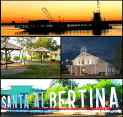
Santa Albertina
| Santa Albertina | ||
|---|---|---|
| Municipality | ||
 | ||
| ||
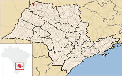 Location in São Paulo state | ||
 Santa Albertina Location in Brazil | ||
| Coordinates: 20°1′55″S 50°43′40″W / 20.03194°S 50.72778°WCoordinates: 20°1′55″S 50°43′40″W / 20.03194°S 50.72778°W | ||
| Country |
| |
| Region | Southeast Region | |
| State | São Paulo | |
| Mesoregion | São José do Rio Preto | |
| Microregion | Jales | |
| Area | ||
| • Total | 272 km2 (105 sq mi) | |
| Elevation | 420 m (1,380 ft) | |
| Population (2015) | ||
| • Total | 5,971 | |
| • Density | 22/km2 (57/sq mi) | |
| Time zone | BRT/BRST (UTC-3/-2) | |
| Website |
www | |

Santa Albertina is a municipality in the state of São Paulo in Brazil. The population is 5,971 (2015 est.) in an area of 272 km².[1] The elevation is 420 m. It is situated on the border with the state of Minas Gerais, on the left bank of the Rio Grande.
Neighbouring Municipalities
Distances
- Brasília (Capital City Of Brazil) : 754 km
- São Paulo (Capital City Of The State Of São Paulo) : 621 km
- São José do Rio Preto : 179 km
- Araçatuba : 150 km
- Jales : 32 km
References
This article is issued from Wikipedia - version of the 8/28/2016. The text is available under the Creative Commons Attribution/Share Alike but additional terms may apply for the media files.