Sanjiang Dong Autonomous County
| Sanjiang County 三江县 · Sanhgyangh Yen | |
|---|---|
| County | |
| Sanjiang Dong Autonomous County 三江侗族自治县 Sanhgyangh Dungcuz Swciyen | |
|
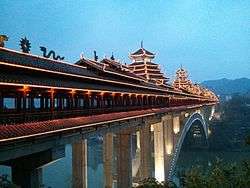
The Sanjiang Fengyu Bridge | |
 Sanjiang Location in Guangxi | |
| Coordinates: 25°47′02″N 109°36′22″E / 25.784°N 109.606°ECoordinates: 25°47′02″N 109°36′22″E / 25.784°N 109.606°E[1] | |
| Country | People's Republic of China |
| Autonomous region | Guangxi |
| Prefecture-level city | Liuzhou |
| Area[2] | |
| • Total | 2,429.72 km2 (938.12 sq mi) |
| Population (2010)[3] | |
| • Total | 297,244 |
| • Density | 120/km2 (320/sq mi) |
| Time zone | China Standard (UTC+8) |
| Postal code | 5455XX |
Sanjiang Dong Autonomous County (simplified Chinese: 三江侗族自治县; traditional Chinese: 三江侗族自治縣; pinyin: Sānjiāng Dòngzú Zìzhìxiàn; Standard Zhuang: Sanhgyangh Dungcuz Swciyen) is under the administration of Liuzhou, Guangxi Zhuang Autonomous Region, China. It is a region traditionally inhabited by the Dong people, bordering the prefecture-level divisions of Qiandongnan (Guizhou) to the north, Huaihua (Hunan) to the northeast and Guilin to the west.
It has an area of 2454 square kilometers and a population of 350,000.[4]
Transportation
- China National Highway 209
- Reach by Bus from Longsheng about 1.5 hours, Guilin 4.5 hours
- Sanjiang County Railway Station, about 10km from the main square and "Bird's Nest" bullfighting arena.
- Sanjiang South Railway Station, also about 10km south from the main square. This train station mainly serves the Guiyang Guangzhou high speed railway that pass through the area.
Tourism
20 km north of Sanjiang, toward Hunan province, lies the Dong district, Chengyang (程阳) which is becoming a popular tourist destination with backpackers. The district comprises eight traditional Dong minority villages. The houses are all made of wood. Inside the villages you will find traditional drum towers, which were used to announce important things or simply to perform plays to entertain the villagers. Crossing the river is the best preserved Wind and Rain Bridge (程阳风雨桥, chéng yáng fēng yǔ qiáo) which has five parts. The bridge dates to the 1920s and is for many people the main reason to visit the village.
North of Chengyang lies the tiny village of Linxia which is interesting because of the local market. There are no places to stay in Linxia, but a taxi from Sanjiang or Chengyang brings you there easily.
Notable people from Sanjiang
- Wu Hongfei, journalist, novelist, and rock singer
See also
References
- ↑ Google (2014-07-02). "Sanjiang" (Map). Google Maps. Google. Retrieved 2014-07-02.
- ↑ Liuzhou City Land Use Plan (2006–20)/《柳州市土地利用总体规划(2006-2020年)》.(Chinese) Accessed 8 July 2014.
- ↑ 《中国2010年人口普查分县资料》 (in Chinese). 中国统计出版社. December 2012. ISBN 978-7-5037-6659-6.
- ↑ (Chinese) Profile of Sanjiang, official website of Sanjiang County Government, visited on May 12, 2008.
External links
| Wikimedia Commons has media related to Sanjiang Dong Autonomous County. |