Sandusky River

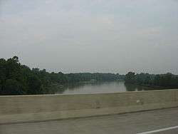
The Sandusky River (Shawnee: Potakihiipi [1]) is a tributary to Lake Erie in north-central Ohio in the United States. It is about 133 miles (214 km) long[2] and flows into Lake Erie at Sandusky Bay.
The Sandusky River, like the Maumee River to the west, is home to the annual walleye run in the spring, specifically March–April. The river also receives a run of white bass around the same time in the spring. The numbers of walleye that swim upstream to spawn aren't as great as those that return to the Maumee River. The fish can also swim farther upstream and have access to more spawning areas than in the Sandusky River. The Ballville dam, along the Sandusky River, in Fremont, Ohio blocks the migration for walleye and other fish trying to spawn. The removal of it would allow for the walleye, and other fish, to access much more spawning area further upstream boosting the population of fish in Ohio. The Ballville Dam currently has no use, however the city of Fremont has considered tearing it down or repairing it, but no official decision has been made yet.
The river's name derives from Wyandot saandusti, meaning "water (within water-pools)"[3] or from andusti, meaning "cold water".[4]
Course
The Sandusky River begins at the juncture of Paramour Creek and Allen Run at the unincorporated community of Leesville in Crawford County west of Crestline,[5] and initially flows westwardly, passing through the town of Bucyrus. In Wyandot County the river turns northward for the remainder of its course, flowing through Seneca and Sandusky counties and passing the towns of Upper Sandusky, Tiffin and Fremont before entering Sandusky Bay.
In 1970, the river's course between Upper Sandusky and Fremont was designated a State Scenic River by the government of Ohio.
Little Sandusky River
The Little Sandusky River is a minor tributary of the Sandusky. It flows 14.0 miles (22.5 km)[2] northward from northern Marion County and joins the Sandusky in southern Wyandot County.
Variant names
According to the Geographic Names Information System, the Sandusky River has also been known as:
- Potake Sepe
- Riviere Blanc
- Riviere Sanduski
- San-doo-stee River[5]
See also
References
- ↑ "Shawnees Webpage". Shawnee's Reservation. 1997. Retrieved 2013-04-26.
- 1 2 U.S. Geological Survey. National Hydrography Dataset high-resolution flowline data. The National Map, accessed May 19, 2011
- ↑ Johnston, John (1858). Vocabularies of the Shawanoese and Wyandott Languages, etc. Retrieved 2012-10-20.
- ↑ "Wyandot Dictionary" (PDF). Retrieved 2012-10-20.
- 1 2 U.S. Geological Survey Geographic Names Information System: Sandusky River
External links
- Ohio DNR Sandusky State Scenic River website
- Sandusky River Watershed Coalition
- Sandusky River - Ohio History Central
Coordinates: 41°28′15″N 82°53′50″W / 41.4708°N 82.8973°W