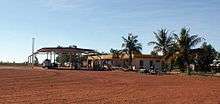
Sandfire, Western Australia
Coordinates: 19°46′01″S 121°05′30″E / 19.767027°S 121.091609°E
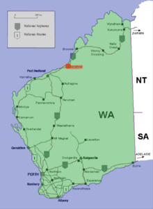
Sandfire is a location and roadhouse on the Great Northern Highway in Western Australia between Port Hedland and Broome. It is on the western edge of the Great Sandy Desert, and east of Wallal Downs and Mandora Station. It is inland, and located 20 km from the coast in the region of the Mandora Marsh and the Eighty Mile Beach, 45 km north of the Kidson Track turnoff. The area surrounding the roadhouse is of high cultural significance to the Nyangumarta People, who hold native title over the area.
It is only one of three fuel stations (the others being Pardoo and Roebuck roadhouses) in the 610 km between those two towns.
In April 2007, the Sandfire Roadhouse was extensively damaged by fire leaving a $1.5 million damage bill.[1] It was damaged again in December 2009 [2] In Cyclone seasons in 2011 and 2012 the location was included in warnings [3]
The petrol station, restaurant, bar, caravan park and motel accommodation is available between 7am and 7pm every day of the year.
Notes
- ↑ "Sandfire roadhouse burns down". The Sunday Times. 11 April 2007.
- ↑ http://www.abc.net.au/news/stories/2009/12/22/2777990.htm?section=justin
- ↑ "CYCLONE WARNING ISSUED FOR W.AUSTRALIA'S PILBARA COAST", AsiaPulse News, Asia Pulse Pty Ltd, 2011-01-24, retrieved 21 January 2012
External links
Further reading
- Thomas, Athol, (1987) Biography on the owner of the Sandfire roadhouse in 1987 - Eddie Norton West Australian, 10/3/1987, p. 57