San Simeon, California
| San Simeon | |
|---|---|
| census-designated place | |
|
View of Hearst Castle, a prominent landmark in San Simeon | |
 San Simeon Location within the state of California | |
| Coordinates: 35°38′38″N 121°11′23″W / 35.64389°N 121.18972°WCoordinates: 35°38′38″N 121°11′23″W / 35.64389°N 121.18972°W | |
| Country |
|
| State |
|
| County | San Luis Obispo |
| Area[1] | |
| • Total | 0.797 sq mi (2.063 km2) |
| • Land | 0.797 sq mi (2.063 km2) |
| • Water | 0 sq mi (0 km2) 0% |
| Elevation[2] | 230 ft (70 m) |
| Population (2010) | |
| • Total | 462 |
| • Density | 580/sq mi (220/km2) |
| Time zone | Pacific (PST) (UTC-8) |
| • Summer (DST) | PDT (UTC-7) |
| ZIP codes | 93452 |
| Area code(s) | 805 |
| GNIS feature ID | 2583127 |
| U.S. Geological Survey Geographic Names Information System: San Simeon, California | |
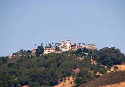


San Simeon (ZIP Code: 93452; area code 805) is a town and census-designated place[2] on the Pacific coast of San Luis Obispo County, California. Its position along State Route 1 is approximately halfway between Los Angeles and San Francisco, each of those cities being roughly 230 miles (370 km) away. A key feature of the area is Hearst Castle, a hilltop mansion built by William Randolph Hearst in the early 20th century that is now a tourist attraction. The area is also home to a large northern elephant seal rookery, known as the Piedras Blancas rookery. It is located seven miles north of San Simeon on Highway 1.
History
Prehistorically the local area was inhabited by the Chumash people, who settled the coastal San Luis Obispo area approximately 10,000 to 11,000 BC, including a large village south of San Simeon at Morro Creek.[3]
The first European land exploration of Alta California, the Spanish Portolà expedition, traveled northwest along the coast in September, 1769. On September 11-12, the party passed the future location of San Simeon. At Ragged Point, about 15 miles past San Simeon, the party turned inland across the Santa Lucia Range.[4]
San Simeon was founded as an asistencia ("sub-mission") to Mission San Miguel Arcángel, founded in 1797 and located to the east across the Santa Lucia Range. San Simeon was named for Rancho San Simeon, although the town-site is actually north of that rancho, on the former Rancho Piedra Blanca, a Mexican land grant given in 1840 to José de Jesús Pico. In 1865, Pico sold part of the rancho to George Hearst, the father of William Randolph Hearst.
The first Europeans to settle in the immediate area near the bay of San Simeon were Portuguese shore whalers under the command of Captain Joseph Clark (born Machado) from the Cape Verde Islands, around 1864. [5] In 1869, Captain Clark built a wharf near the point for his whaling station. A small community grew near the 1869 wharf, but the waves near the wharf were too high, and the wharf was abandoned. In 1878, Hearst built a new wharf, and the small community moved near the new wharf. A general store (later Sebastian's Store) was built near the Clark wharf, and then relocated near the 1878 wharf. [6] Shore whaling continued on the point until the mid-1890s. It ceased for a short time, started up again in 1897, and continued to about 1908 when it ceased for good.[7]
In 1953, the Hearst Corporation donated the William Randolph Hearst Memorial Beach, including the Hearst Pier, to San Luis Obispo County. It is currently part of Hearst San Simeon State Park.[8] The present-day San Simeon pier was built in 1957.[9]
Geology
The name San Simeon also refers to some geologic structures of the area, particularly elements of the coastal Jurassic Age landforms and ophiolite mineral formations.[10]
Geography
According to the United States Census Bureau, the census-designated place covers an area of 0.8 square miles (2.1 km2), all of it land. The original townsite of San Simeon is at San Simeon Bay, and was the important 19th-century shipping point with the successive wharves that were built. San Simeon Acres, about four miles south of the original townsite at the mouth of Pico Creek, and so about halfway between old San Simeon and Cambria, was established in the 1950s. Most of the development at San Simeon Acres was in the 1960s to the 1980s. Many motels and cafes serve visitors to Hearst Castle.[11]
Demographics
The 2010 United States Census[12] reported that San Simeon had a population of 462. The population density was 579.9 people per square mile (223.9/km2). The racial makeup of San Simeon was 270 (58.4%) White, 4 (0.9%) African American, 5 (1.1%) Native American, 9 (1.9%) Asian, 2 (0.4%) Pacific Islander, 160 (34.6%) from other races, and 12 (2.6%) from two or more races. Hispanic or Latino of any race were 258 persons (55.8%).
The Census reported that 461 people (99.8% of the population) lived in households, 1 (0.2%) lived in non-institutionalized group quarters, and 0 (0%) were institutionalized.
There were 197 households, out of which 53 (26.9%) had children under the age of 18 living in them, 94 (47.7%) were opposite-sex married couples living together, 14 (7.1%) had a female householder with no husband present, 13 (6.6%) had a male householder with no wife present. There were 12 (6.1%) unmarried opposite-sex partnerships, and 5 (2.5%) same-sex married couples or partnerships. 67 households (34.0%) were made up of individuals and 30 (15.2%) had someone living alone who was 65 years of age or older. The average household size was 2.34. There were 121 families (61.4% of all households); the average family size was 3.00.
The population was spread out with 106 people (22.9%) under the age of 18, 31 people (6.7%) aged 18 to 24, 112 people (24.2%) aged 25 to 44, 130 people (28.1%) aged 45 to 64, and 83 people (18.0%) who were 65 years of age or older. The median age was 40.7 years. For every 100 females there were 105.3 males. For every 100 females age 18 and over, there were 102.3 males.
There were 301 housing units at an average density of 377.8 per square mile (145.9/km2), of which 87 (44.2%) were owner-occupied, and 110 (55.8%) were occupied by renters. The homeowner vacancy rate was 2.2%; the rental vacancy rate was 11.3%. 143 people (31.0% of the population) lived in owner-occupied housing units and 318 people (68.8%) lived in rental housing units.
References
- ↑ U.S. Census
- 1 2 U.S. Geological Survey Geographic Names Information System: San Simeon, California
- ↑ C. Michael Hogan (2008). "Morro Creek". The Megalithic Portal, ed. A. Burnham.
- ↑ Bolton, Herbert E. (1927). Fray Juan Crespi: Missionary Explorer on the Pacific Coast, 1769-1774. HathiTrust Digital Library. pp. 188–191. Retrieved April 2014. Check date values in:
|access-date=(help) - ↑ Shore Whaling at San Simeon Bay by Robert C. Pavlik
- ↑ History of Sebastian's Store
- ↑ Bertao, David E. The Portuguese Shore Whalers of California, 1854-1904. San Jose, Calif.: The Portuguese Heritage Publications, 2006. pp. 159-169, 177.
- ↑ W.R. Hearst Memorial Beach at California State Parks
- ↑ San Simeon History & Timeline
- ↑ James E. Wright, John W. Shervais (2008) Ophiolites, Arcs, and Batholiths: A Tribute to Cliff Hopson, Geological Society of America, ISBN 0-8137-2438-4, 572 pages
- ↑ San Simeon Acres
- ↑ "2010 Census Interactive Population Search: CA - San Simeon CDP". U.S. Census Bureau. Retrieved July 12, 2014.
External links
| Wikimedia Commons has media related to San Simeon, California. |
| Wikivoyage has a travel guide for San Simeon. |
Municipalities and communities of San Luis Obispo County, California, United States | ||
|---|---|---|
| Cities |  | |
| CDPs | ||
| Unincorporated communities | ||
| Ghost towns | ||