St. Landry Parish, Louisiana
| Saint Landry Parish, Louisiana | |
|---|---|
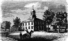 St Landry Parish Courthouse at Opelousas during the Civil War | |
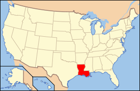
 Location in the U.S. state of Louisiana | |
 Louisiana's location in the U.S. | |
| Founded | 1807 |
| Named for | Saint Landry |
| Seat | Opelousas |
| Largest city | Opelousas |
| Area | |
| • Total | 939 sq mi (2,432 km2) |
| • Land | 924 sq mi (2,393 km2) |
| • Water | 15 sq mi (39 km2), 1.6% |
| Population | |
| • (2010) | 83,384 |
| • Density | 90/sq mi (35/km²) |
| Congressional districts | 3rd, 4th, 5th |
| Time zone | Central: UTC-6/-5 |
| Website |
www |
St. Landry Parish (French: Paroisse de Saint-Landry) is a parish located in the U.S. state of Louisiana. As of the 2010 census, the population was 83,384.[1] The parish seat is Opelousas.[2] The parish was created in 1807.[3]
St. Landry Parish comprises the Opelousas, LA Micropolitan Statistical Area, which is also included in the Lafayette-Opelousas-Morgan City, LA Combined Statistical Area. It is at the heart of Creole and Cajun culture and heritage in Louisiana.
History
French and Spanish Terrory
The land which became St. Landry Parish was inhabited since at least 10,500 B.C., as deduced from excavations of three prehistoric dwelling sites. By the 15th century, the Appalousa Indians settled in the area situated between Atchafalaya River and Sabine River (at the border of Texas-Louisiana). The Appalousa were warlike and preyed on neighbors to defend their own territory.
The first European recorded in the Appalousa territory was a French trader named Michel de Birotte. He came in 1690 and negotiated with the Appalousa nation. Nine years later, France named Louisiana as a colony and defined the land occupied by the Appalousa as the Opelousas Territory. The area south of the Opelousas Territory between the Atchafalaya River, the Gulf of Mexico and Bayou Nezpique, occupied by the Attakapas Indians (Eastern Atakapa), was named Attakapas Territory.
In 1720 France established the Opelousas Post slightly north of the contemporary city of Opelousas.[4] It was a major trading organization for the developing area. In addition France established the Attakapas Post (near the present St Martinville) in the Attakapas Territory. France gave land grants to soldiers and settlers to encourage development. Most settlers were French immigrants. Tradition says that Jean Joseph LeKintrek and Joseph Blainpain, who had formed a partnership to trade with the Appalousa Indians, came in the early 1740s. They brought three enslaved Africans, the first to live in the area.
Some Indians sold land to the newcomers. When the Eastern Attakapas Chief Kinemo sold all the land between Vermilion River and Bayou Teche to Frenchman Gabriel Fuselier de la Claire in 1760, however, the angry Appalousa tribe exterminated the Attakapas (Eastern Atakapa).
France ceded Louisiana and its territories to Spain in 1762. Under Spanish rule, Opelousas Post became the center of government for Southwest Louisiana. By 1769 about 100 families were living in Opelousas Post. Between 1780 and 1820, the first settlers were joined by others coming from the Attakapas Territory, from the Pointe Coupée Territory, and east from the Atchafalaya River area. They were joined by immigrants from the French West Indies, who left after Haiti/St. Domingue became independent in a slave revolution. Most of the new settlers were French, Spaniards, French Creoles, Spanish Creoles, Africans and African Americans.
The group from Attakapas Post included many Acadians. These were French who migrated from Nova Scotia in 1763, after their expulsion by the English in the aftermath of France's defeat in the Seven Years' War (known in North America as the French and Indian War). They were led by Jean-Jacques Blaise d'Abbadie. D'Abbadie was Governor of the territory from 1763 to 1765. The French community built St Landry Catholic Church in 1767, dedicated to St. Landry, the Bishop of Paris in the 7th century.[5]
On April 10, 1805, after the United States had acquired the Louisiana Purchase, the post was named the town of Opelousas and became the seat of the County of Opelousas, part of the Territory of Orleans. In 1807, when the territory was reorganized into parishes, Opelousas was designated the seat of St. Landry Parish.[6]
Purchase by the United States
The United States gained control of the territory in 1803 through the Louisiana Purchase. Americans from the South and other parts of the United States began to migrate to the area, marking the arrival of the first large English-speaking population and the introduction of the need for more general use of English.[4]
St. Landry Parish was officially established on April 10, 1805 by a legislative act, becoming the largest parish in the Louisiana state. The new parish was named after the Catholic Church located near the Opelousas Post. The church had been named in honor of St. Landry, the Bishop of Paris in 650.[4] The parish's boundaries encompassed about half the land of the Opelousas Territory, between the Atchafalaya River and Sabine River, between Rapides Parish and Vernon Parish, and Lafayette and St. Martin Parishes. Since then, the area of the parish has decreased, as six additional parishes have been created from its territory. These include Calcasieu, Acadia, Evangeline, Jeff Davis, Beauregard, and Allen.[4]
In 1821 the second educational institution west of the Mississippi was founded in Grand Coteau. In this community south of Opelousas is the Academy of the Sacred Heart, a private Catholic school founded by the French Creole community.[7]
The city of Opelousas has been the seat of government for the St Landry Parish since its formation.[4] After Baton Rouge fell to the Union troops during the Civil War in 1862, Opelousas became the state capital for nine months. The capital was moved again in 1863, this time to Shreveport when Union troops occupied Opelousas.[8][9]
Geography
According to the U.S. Census Bureau, the parish has a total area of 939 square miles (2,430 km2), of which 924 square miles (2,390 km2) is land and 15 square miles (39 km2) (0.6%) is water.[10]
Adjacent parishes
- Avoyelles Parish (north)
- Pointe Coupee Parish (east)
- St. Martin Parish (southeast)
- Lafayette Parish (south)
- Acadia Parish (southwest)
- Evangeline Parish (northwest)
National protected areas
- Atchafalaya National Wildlife Refuge (part)
- Jean Lafitte National Historical Park and Preserve (part, in Eunice)
Major highways
Demographics
| Historical population | |||
|---|---|---|---|
| Census | Pop. | %± | |
| 1830 | 12,591 | — | |
| 1840 | 15,233 | 21.0% | |
| 1850 | 22,253 | 46.1% | |
| 1860 | 23,104 | 3.8% | |
| 1870 | 25,553 | 10.6% | |
| 1880 | 40,004 | 56.6% | |
| 1890 | 40,250 | 0.6% | |
| 1900 | 52,906 | 31.4% | |
| 1910 | 66,661 | 26.0% | |
| 1920 | 51,697 | −22.4% | |
| 1930 | 60,074 | 16.2% | |
| 1940 | 71,481 | 19.0% | |
| 1950 | 78,476 | 9.8% | |
| 1960 | 81,493 | 3.8% | |
| 1970 | 80,364 | −1.4% | |
| 1980 | 84,128 | 4.7% | |
| 1990 | 80,331 | −4.5% | |
| 2000 | 87,700 | 9.2% | |
| 2010 | 83,384 | −4.9% | |
| Est. 2015 | 83,848 | [11] | 0.6% |
| U.S. Decennial Census[12] 1790-1960[13] 1900-1990[14] 1990-2000[15] 2010-2013[1] | |||
As of the 2010 United States Census, there were 83,384 people residing in the parish. 55.9% were White, 41.3% Black or African American, 0.4% Asian, 0.3% Native American, 0.8% of some other race and 1.3% of two or more races. 1.6% were Hispanic or Latino (of any race)
As of the census[16] of 2000, there were 87,700 people, 32,328 households, and 23,211 families residing in the parish. The population density was 94 people per square mile (36/km²). There were 36,216 housing units at an average density of 39 per square mile (15/km²). The racial makeup of the parish was 56.51% White, 42.13% Black or African American, 0.14% Native American, 0.20% Asian, 0.01% Pacific Islander, 0.31% from other races, and 0.70% from two or more races. 0.91% of the population were Hispanic or Latino of any race. 16.7% reported speaking French or Cajun French at home.[17]
There were 32,328 households out of which 36.10% had children under the age of 18 living with them, 49.30% were married couples living together, 17.90% had a female householder with no husband present, and 28.20% were non-families. 25.40% of all households were made up of individuals and 11.40% had someone living alone who was 65 years of age or older. The average household size was 2.67 and the average family size was 3.21.
In the parish the population was spread out with 29.50% under the age of 18, 9.20% from 18 to 24, 26.50% from 25 to 44, 21.40% from 45 to 64, and 13.40% who were 65 years of age or older. The median age was 35 years. For every 100 females there were 91.60 males. For every 100 females age 18 and over, there were 86.80 males.
The median income for a household in the parish was $22,855, and the median income for a family was $28,908. Males had a median income of $29,458 versus $18,473 for females. The per capita income for the parish was $12,042. About 24.70% of families and 29.30% of the population were below the poverty line, including 37.70% of those under age 18 and 27.50% of those age 65 or over.
National Guard
D Company 3-156TH Infantry Battalion resides in Opelousas, Louisiana. This unit as part of 256TH IBCT deployed twice to Iraq, 2004-5 and 2010.
Communities
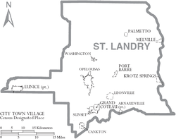
Cities
Towns
Villages
Unincorporated communities
Notable people
- Lottie Beebe
- Gerald Boudreaux
- Armand Brinkhaus
- Tony Chachere
- Cat Doucet
- Gilbert L. Dupré
- E. D. Estilette
- Gregory L. Fruge
- Gordon (slave)
- Elbert Guillory
- Mickey Guillory
- T. H. Harris
- Clay Higgins
- Curtis Joubert
- Bernard LeBas
- Mildred Methvin
- Dustin Miller
- Benjamin Pavy
- Felix Octave Pavy
- Paul Prudhomme
- Dale Sittig
See also
References
- 1 2 "State & County QuickFacts". United States Census Bureau. Retrieved August 18, 2013.
- ↑ "Find a County". National Association of Counties. Retrieved 2011-06-07.
- ↑ "St. Landry Parish". Center for Cultural and Eco-Tourism. Retrieved September 6, 2014.
- 1 2 3 4 5 Hartley, Carola (2003). "Imperial St. Landry Parish". LAGenWeb. Archived from the original on 2007-09-21. Retrieved 2007-03-21.
- ↑ Central Acadiana Gateway: Opelousas and St. Landry Parish, Louisiana State University-Eunice Office of Public Relations, accessed 27 April 2008
- ↑ http://www.cityofopelousas.com/visitors/history-opelousas
- ↑ Central Acadiana Gateway: Opelousas and St. Landry Parish, LSUE Office of Public Relations, 2000, accessed 27 April 2008
- ↑ "Opelousas and St. Landry Parish". Louisiana State University - Eunice. Retrieved 2007-03-19.
- ↑ "Opelousas Facts and History". City of Opelousas. Archived from the original on 2007-07-05. Retrieved 2007-03-19.
- ↑ "2010 Census Gazetteer Files". United States Census Bureau. August 22, 2012. Retrieved September 1, 2014.
- ↑ "County Totals Dataset: Population, Population Change and Estimated Components of Population Change: April 1, 2010 to July 1, 2015". Retrieved July 2, 2016.
- ↑ "U.S. Decennial Census". United States Census Bureau. Retrieved September 1, 2014.
- ↑ "Historical Census Browser". University of Virginia Library. Retrieved September 1, 2014.
- ↑ "Population of Counties by Decennial Census: 1900 to 1990". United States Census Bureau. Retrieved September 1, 2014.
- ↑ "Census 2000 PHC-T-4. Ranking Tables for Counties: 1990 and 2000" (PDF). United States Census Bureau. Retrieved September 1, 2014.
- ↑ "American FactFinder". United States Census Bureau. Retrieved 2008-01-31.
- ↑ MLA Language Map Data Center
Resources
- Jack Claude Nezat The Nezat And Allied Families 1630-2007 Lulu 2007 ISBN 978-2-9528339-2-9, ISBN 978-0-615-15001-7
The author is one of the descendants of "Alexandre of Attakapas", Nezat Alexandre, born 1781 in Attakapas Post and died 1824 (Source Hebert).
External links
| Wikimedia Commons has media related to St. Landry Parish, Louisiana. |
- Official Web Site of St. Landry Parish
- Website for St. Landry Catholic Church Parish
- St. Landry Parish Sheriff's Office
Geology
- Heinrich, P. V., and W. J. Autin, 2000, Baton Rouge 30 x 60 minute geologic quadrangle. Louisiana Geological Survey, Baton Rouge, Louisiana.
- Heinrich, P. V., J. Snead, and R. P. McCulloh, 2003, Crowley 30 x 60 minute geologic quadrangle. Louisiana Geological Survey, Baton Rouge, Louisiana.
- Snead, J., P. V. Heinrich, and R. P. McCulloh, 2002, Ville Platte 30 x 60 minute geologic quadrangle. Louisiana Geological Survey, Baton Rouge, Louisiana.
 |
Evangeline Parish | Avoyelles Parish | | |
| |
Pointe Coupee Parish | |||
| ||||
| | ||||
| Acadia Parish | Lafayette Parish | St. Martin Parish |
Municipalities and communities of St. Landry Parish, Louisiana, United States | ||
|---|---|---|
| Cities | | |
| Towns | ||
| Villages | ||
| CDP | ||
| Other unincorporated communities |
| |
| Footnotes | ‡This populated place also has portions in an adjacent parish or parishes | |
Coordinates: 30°36′N 92°00′W / 30.60°N 92.00°W