Saint-Sauveur, Vienne
| Saint-Sauveur | |
|---|---|
|
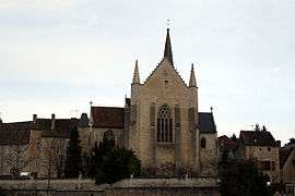
The church of Saint-Sauveur | |
 Saint-Sauveur | |
|
Location within Nouvelle-Aquitaine region  Saint-Sauveur | |
| Coordinates: 46°48′33″N 0°37′26″E / 46.8092°N 0.6239°ECoordinates: 46°48′33″N 0°37′26″E / 46.8092°N 0.6239°E | |
| Country | France |
| Region | Nouvelle-Aquitaine |
| Department | Vienne |
| Arrondissement | Châtellerault |
| Canton | Châtellerault-3 |
| Intercommunality | Pays Châtelleraudais |
| Area1 | 32.37 km2 (12.50 sq mi) |
| Population (2006)2 | 1,073 |
| • Density | 33/km2 (86/sq mi) |
| Time zone | CET (UTC+1) |
| • Summer (DST) | CEST (UTC+2) |
| INSEE/Postal code | 86245 / 86100 |
| Elevation |
72–144 m (236–472 ft) (avg. 144 m or 472 ft) |
|
1 French Land Register data, which excludes lakes, ponds, glaciers > 1 km² (0.386 sq mi or 247 acres) and river estuaries. 2 Population without double counting: residents of multiple communes (e.g., students and military personnel) only counted once. | |
Saint-Sauveur is a former commune in the Vienne department in western France. On 1 January 2016, it was merged into the new commune Senillé-Saint-Sauveur.[1]
Demographics
| Year | 1962 | 1968 | 1975 | 1982 | 1990 | 1999 | 2006 |
|---|---|---|---|---|---|---|---|
| Population | 506 | 597 | 649 | 874 | 1006 | 947 | 1073 |
See also
References
- ↑ Arrêté préfectoral 14 October 2015 (French)
| Wikimedia Commons has media related to Saint-Sauveur (Vienne). |
This article is issued from Wikipedia - version of the 11/19/2016. The text is available under the Creative Commons Attribution/Share Alike but additional terms may apply for the media files.