Saint-Jory-las-Bloux
| Saint-Jory-las-Bloux | ||
|---|---|---|
 | ||
| ||
 Saint-Jory-las-Bloux | ||
|
Location within Nouvelle-Aquitaine region  Saint-Jory-las-Bloux | ||
| Coordinates: 45°21′47″N 0°58′00″E / 45.3631°N 0.9667°ECoordinates: 45°21′47″N 0°58′00″E / 45.3631°N 0.9667°E | ||
| Country | France | |
| Region | Nouvelle-Aquitaine | |
| Department | Dordogne | |
| Arrondissement | Périgueux | |
| Canton | Isle-Loue-Auvézère | |
| Government | ||
| • Mayor (2008–2014) | Rémi Bernier | |
| Area1 | 16.94 km2 (6.54 sq mi) | |
| Population (2008)2 | 252 | |
| • Density | 15/km2 (39/sq mi) | |
| Time zone | CET (UTC+1) | |
| • Summer (DST) | CEST (UTC+2) | |
| INSEE/Postal code | 24429 / 24160 | |
| Elevation |
123–242 m (404–794 ft) (avg. 190 m or 620 ft) | |
|
1 French Land Register data, which excludes lakes, ponds, glaciers > 1 km² (0.386 sq mi or 247 acres) and river estuaries. 2 Population without double counting: residents of multiple communes (e.g., students and military personnel) only counted once. | ||

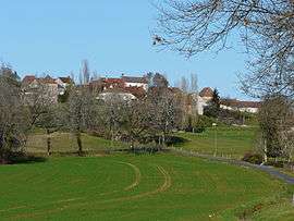
Saint-Jory-las-Bloux is a commune in the Dordogne department in Nouvelle-Aquitaine in southwestern France.
Geography
The commune is situated on a promontory above the river Isle, on the border of Périgord Blanc and the Périgord Vert. It is a green area, with springs and limestone rocks.
Population
| Historical population | ||
|---|---|---|
| Year | Pop. | ±% |
| 1962 | 250 | — |
| 1968 | 271 | +8.4% |
| 1975 | 229 | −15.5% |
| 1982 | 251 | +9.6% |
| 1990 | 241 | −4.0% |
| 1999 | 237 | −1.7% |
| 2008 | 252 | +6.3% |
Sights
- A château built during the 16th and the 17th centuries.
See also
References
External links
| Wikimedia Commons has media related to Saint-Jory-las-Bloux. |
This article is issued from Wikipedia - version of the 11/9/2016. The text is available under the Creative Commons Attribution/Share Alike but additional terms may apply for the media files.