Single-point urban interchange
A single-point urban interchange (SPUI, /ˈspuːiː/ or /ˈspjuːiː/), also called a single-point interchange (SPI)[1] or single-point diamond interchange (SPDI), is a type of highway interchange. The design was created in order to help move large volumes of traffic through limited amounts of space safely and efficiently.
Description
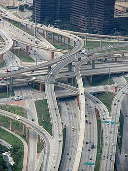
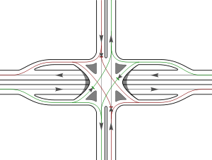
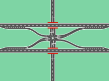
A single point urban interchange is similar in form to a diamond interchange, but has the advantage of allowing opposing left turns to proceed simultaneously by compressing the two intersections of a diamond into one single intersection over or under the free-flowing road.[2]
The term "single point" refers to the fact that all through traffic on the arterial street, as well as the traffic turning left onto or off the interchange, can be controlled from a single set of traffic signals. Due to the space efficiency of SPUIs relative to the volume of traffic they can handle, the interchange design is being used extensively in the reconstruction of existing freeways as well as constructing new freeways, particularly in dense urban environments.[3]
Sometimes a SPUI will allow traffic to proceed straight through from the off-ramp to the on-ramp; this usually happens when the ramps connect with frontage roads. Since most through traffic travels over or under the intersection, the SPUI is still much more efficient than a surface intersection.
Advantages
The most commonly cited advantages of single point urban interchanges are improved operation efficiency and safety as well as reduced right-of-way requirements compared to other interchange forms.[4] Left turning traffic from both directions of the intersecting roadways are able to turn simultaneously without crossing the path of the opposing left turns. Because traffic passing through the interchange can be controlled by a single signal, vehicles can clear the intersection much more quickly than in a diamond interchange (which requires two sets of traffic signals).
SPUIs also allow for wider turns, easing movement for large vehicles such as trucks and RVs. Furthermore, a SPUI takes up considerably less space than a full cloverleaf interchange, allowing construction to take place on a limited amount of property and minimizing state use of eminent domain.[5]
Finally, single point urban interchanges are reportedly safer than other space-efficient interchange forms such as (standard) diamond interchanges. Research suggests that, although there may not be a significant difference between the two types of interchanges in terms of total collisions, the injury and fatality rates are notably lower for SPUIs than diamond interchanges.[6]
Disadvantages
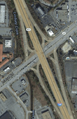
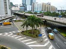
The major disadvantage of single point urban interchanges over other types of road junctions is the increased cost due to the need for a longer or wider bridge. A freeway-under SPUI (as in the upper diagram) requires a wider bridge over the free-flowing road to make room for the compressed on- and off-ramps. However, this disadvantage poses less of a problem in cases where the arterial, or non-freeway road already requires a very wide bridge. The intersection of 97 Street, having seven through lanes, with Yellowhead Trail in Edmonton, Alberta, Canada, though a diamond interchange in concept, required such a wide bridge that traffic-signal phasing allows this intersection to behave as a SPUI.53°34′53″N 113°29′31″W / 53.58139°N 113.49194°W A freeway-over SPUI (as in the lower photo) requires a longer bridge of the free-flowing road to cross the wider area required for the SPUI intersection below.[7]
Additionally, because vehicles must be able to cross the pavement in six different ways, a SPUI generally has a very large area of uncontrolled pavement in the middle of the intersection. This can be unsafe particularly if drivers are unfamiliar with the interchange type. Drivers making a left turn may become confused as oncoming turning traffic passes them on the right-hand side (or left-hand side in countries that drive on the left).[7]
Also, due to the large intersection area, the traffic lights need a longer yellow and red phase to clear the intersection, and even then it may not be long enough for a bicyclist entering on green or yellow to make it across before opposing traffic gets a green.[4] In general, SPUI designs should not be used where bicycle traffic is expected unless fairly substantial changes to the design or special accommodations are provided.[8]
Pedestrians are usually not able to get through the intersection with one green light. It can take up to four cycles to walk through the entire length of a SPUI.[8]
Finally, SPUIs can be somewhat difficult to clear of snow. The large area in which lanes cross may have to be shut down to allow efficient and thorough cleaning lest a snowplow leave piles of snow, interfering with traffic and visibility in the middle of the uncontrolled pavement. Additionally, if the wide area of uncontrolled pavement is on a bridge, as in the diagram, the snow cannot be pushed to the sides of the bridge as it may pose a hazard to the road underneath. This problem can be exacerbated by the comparatively large bridge width required by the SPUI.
Given that a SPUI allows only left and right turns, drivers may not re-enter the freeway they are departing (if, for example, they realize that they have taken the wrong exit) within a SPUI.
Three-phase traffic signals are required. Other interchange types designed for efficiency, such as the six ramp parclo and the diverging diamond, require just two signal phases.
History
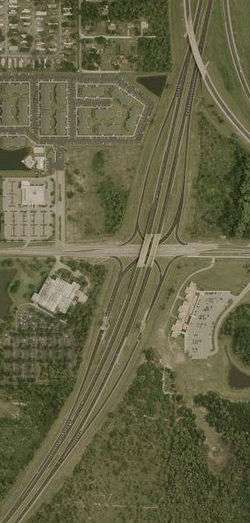
The first SPUI opened on February 25, 1974 along US 19 (SR 55), which goes over SR 60 east of Clearwater, Florida. It was designed by Wallace Hawkes, Director of Transportation Engineering at J.E. Greiner, Inc. (later URS Corporation), who has been called the "granddaddy of the urban interchange".[7] This design has recently been altered to include frontage roads in each direction.[9]
Several SPUIs, built in the 1970s and later, are located on German autobahns like the A40, A42, A44, A46, A57, A59 and A113 in Berlin. There is also a SPUI on the Frankenschnellweg, the urban part of the A73, and Maximilianstraße, in Nuremberg (at 49°27′06″N 11°02′17″E / 49.451708°N 11.038102°E). Smaller versions of the SPUI can also be found on non-autobahn roads in German cities, with right-turning traffic under signal control, located in Heilbronn, Karlsruhe, Sindelfingen, Stuttgart and Wiesbaden.
Use in Asia-Pacific
Hong Kong
22°21′20″N 114°07′24″E / 22.355632°N 114.12323°E
- Tsuen Wan Road (Route 5) and Kwai Tsing Road / Hing Fong Road, called the Kwai Tsing Interchange, in Kwai Tsing, Hong Kong. (22°21′20″N 114°07′24″E / 22.355632°N 114.12323°E)
Indonesia
- Jakarta Inner Ring Road (National Route 1) and Gedong Panjang in Jakarta, Indonesia. (6°07′53″S 106°48′21″E / 6.131461°S 106.805702°E)
Singapore
Beside some diamond interchanges, there are SPUIs at Eunos Flyover at 1°19′34″N 103°54′21″E / 1.326191°N 103.905765°E, Loyang Flyover at 1°21′37″N 103°57′40″E / 1.360214°N 103.961109°E and the Paya Lebar interchange at 1°19′22″N 103°53′27″E / 1.322866°N 103.890912°E.
Australia
The style of interchange is becoming increasingly common in Australia, with variations of the design found in Sydney (33°45′32″S 151°02′57″E / 33.7588031°S 151.0491352°E), Melbourne (37°48′15″S 145°10′41″E / 37.80407°S 145.1781235°E), Brisbane (27°24′40″S 153°03′34″E / 27.4111344°S 153.0594738°E) and Perth (31°58′24″S 115°57′29″E / 31.9733993°S 115.9581574°E)
Inverted SPUI
A rarely built variant of the SPUI is the inverted SPUI, in which the carriageways of the free-flowing road are separated, with left on- and off-ramps running between the carriageways and coming to a single at-grade intersection with the cross street. This can be built less expensively than a standard SPUI by allowing for shorter, simpler bridges at the interchange. However, this inverts the usual convention of placing carriageway on- and off-ramps on the right side of the carriageway, instead placing them on the left side, usually considered the passing lane.
Notable examples
- Interstate 290 in Oak Park, Illinois, near Chicago, at South Harlem Avenue (41°52′25″N 87°48′16″W / 41.873635°N 87.804505°W) and at South Austin Boulevard (41°52′16″N 87°46′28″W / 41.871107°N 87.774331°W).[10]
- Greensboro, North Carolina connecting West Wendover Avenue to South Holden Road (36°03′53″N 79°50′53″W / 36.064781°N 79.848098°W).[11]
- Interstate 244 in Tulsa, Oklahoma, at Sheridan Road (36°09′48″N 95°54′16″W / 36.163289°N 95.904535°W) and at Memorial Drive (36°09′44″N 95°53′13″W / 36.16234°N 95.886873°W).
- U.S. Route 422 in Reading, Pennsylvania at U.S. Route 222 Business (40°19′28″N 75°56′01″W / 40.324345°N 75.933566°W).
Continuous green-T (or seagull) hybrid
There is also a variant of the inverted SPUI which can be used when a side road ends at, rather than crossing, a free-flowing road. In this variant, one carriageway of the free-flowing road is grade-separated from the side road, as with a typical inverted SPUI; while the other carriageway of the free-flowing road is at-grade with, but still separated from the side road, as found in a continuous green T- (or seagull) intersection.
There is one such interchange in Pultney Township, Belmont County, Ohio, between State Route 7 and Interstate 470, at 40°02′52″N 80°44′01″W / 40.047657°N 80.733542°W. The ramps leading to and from I-470 run west of, but are not directly connected to SR 7; these ramps form the "side road" at this interchange. The southbound carriageway of SR 7 bridges over the interchange, while its northbound carriageway remains at-grade. SR 7's left on- and off-ramps run between its carriageways, meeting the I-470 ramps at an at-grade intersection. The I-470 ramps proceed to a trumpet interchange with I-470. I-470 itself bridges over both carriageways of SR 7 a short distance north of the I-470/SR 7 ramps' intersection. This design was likely chosen not for cost savings, but because the northbound carriageway of SR 7 is bordered by railroad tracks, commercial properties and the Ohio River, and because I-470 bridges the river just east of SR 7—a more conventional interchange design was likely more difficult to achieve.
There is another such interchange in Millvale, Pennsylvania, near Pittsburgh, at the junction between PA 28 and the 40th Street Bridge. The northbound carriageway of PA 28 passes under the interchange, with left-hand ramps meeting at the bridge (the northbound entrance ramp does not provide direct access to PA 28). The southbound carriageway of PA 28 has a continuous green T-intersection with the bridge.[12]
Such an interchange formerly existed at the junction of SR 7 and SR 822 at the now-demolished Fort Steuben Bridge in Steubenville, Ohio. The northbound carriageway of SR 7 passed under the bridge, with left-hand ramps meeting the bridge approach, while the southbound carriageway had a continuous green T-intersection with the bridge.[13]
See also
References
- ↑ http://wisconsindot.gov/dtsdManuals/traffic-ops/programs/training/innovative-intersection-ppt.pdf
- ↑ Anonymous (July 1989). "Urban interchange moves more traffic in same space; a design new to California improves congested diamond interchanges without taking more high-priced real estate". Highway & Heavy Construction. 132 (8): 52–53. ISSN 0362-0506.
- ↑ St. Louis District. "Single Point Urban Interchanges". Missouri Department of Transportation. Retrieved July 15, 2012.
- 1 2 Bonneson, James A. (January 1993). "Bridge Size and Clearance Time of Single Point Urban Interchange". Journal of Transportation Engineering. American Society of Civil Engineers. 119 (1): 77–93. doi:10.1061/(ASCE)0733-947X(1993)119:1(77). ISSN 0733-947X.
- ↑ St. Louis District. "Single Point Urban Interchange Frequently Asked Questions". Missouri Department of Transportation. Retrieved July 15, 2012.
- ↑ Bared, Joe; Powell, Alvin; Kaisar, Evangelos; Jagannathan, Ramanujan (May 2005). "Crash Comparison of Single Point and Tight Diamond Interchanges". Journal of Transportation Engineering. American Society of Civil Engineers. 131 (5): 379–381. doi:10.1061/(ASCE)0733-947X(2005)131:5(379). ISSN 0733-947X.
- 1 2 3 "Single-point Urban Interchange (SPUI)". Kurumi.com. Retrieved April 9, 2008.
- 1 2 Qureshi, Mohammad; Sugathan, Navin; Lasod, Rohit; Spring, Gary (September 2004). "Design of Single Point Urban Interchanges, Research Investigation 02-015" (PDF). Missouri Department of Transportation Research, Development, and Technology, University of Missouri-Rolla. Retrieved February 10, 2010.
- ↑ "Google Maps". Google Maps. Retrieved 2016-08-28.
- ↑ Lothson, Anna. "IDOT to discuss I-290 interchanges at Austin, Harlem in Oak Park". Wednesday Journal Inc. Retrieved July 27, 2015.
- ↑ Reid, Jonathan (July 2004). "Unconventional Arterial Intersection Design, Management and Operations Strategies" (PDF). Parsons Brinckerhoff. Retrieved September 9, 2012.
- ↑ Schmitz, Jon (September 28, 2011). "Whole new Route 28 beginning to emerge through construction". Pittsburgh Post-Gazette. Retrieved August 4, 2015.
- ↑ Technical Services. "Straight Line Diagrams: Jefferson County, SR 7" (PDF) (PDF). Ohio Department of Transportation. Archived (PDF) from the original on October 27, 2013. Retrieved August 4, 2015.
External links
| Wikimedia Commons has media related to Single-point urban interchanges. |
- Michigan Department of Transportation page about SPUIs
- Missouri Department of Transportation page about SPUIs
- Page about SPUIs at kurumi.com