Rusholme
| Rusholme | |
 Wilmslow Road in Rusholme |
|
 Rusholme |
|
| Population | 13,643 (2011) |
|---|---|
| OS grid reference | SJ850953 |
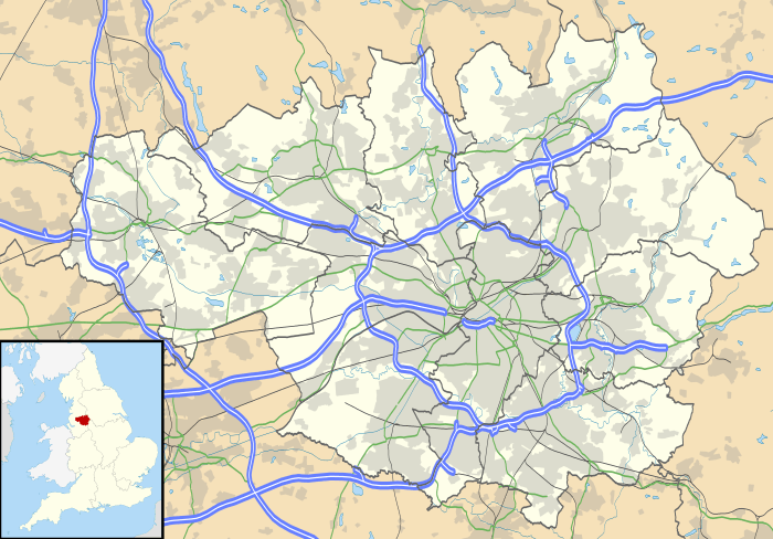
| Metropolitan borough | City of Manchester |
| Metropolitan county | Greater Manchester |
| Region | North West |
| Country | England |
| Sovereign state | United Kingdom |
| Post town | MANCHESTER |
| Postcode district | M14 |
| Dialling code | 0161 |
| Police | Greater Manchester |
| Fire | Greater Manchester |
| Ambulance | North West |
| EU Parliament | North West England |
| UK Parliament | Manchester Gorton |
|
|
Coordinates: 53°27′16″N 2°13′29″W / 53.4544°N 2.2247°W
Rusholme is an inner-city area of Manchester, England, about two miles south of the city centre. The population of Rusholme ward at the 2011 census was 13,643.[1] Rusholme is bounded by the neighbourhoods of Chorlton-on-Medlock to the north, Victoria Park and Longsight to the east, Fallowfield to the south and Moss Side to the west. It has a large student population, with several student halls and many students renting terraced houses, and suburban houses towards the Victoria Park area.
History
Etymology
Rusholme, unlike other place names in Manchester with the suffix holme is not a true water meadow. Its name derives from ryscum the dative plural of the Old English rysc, a "rush" meaning at the rushes. The name was recorded as Russum in 1235, Ryssham in 1316 and Rysholme in 1551.[2]
Early history
Late in the Roman occupation of Britain a hoard of about 200 gold coins was hidden in the valley of the Gore Brook. These coins date from the 2nd and 3rd centuries AD and were found where Birchfields Road crosses the brook in the 1890s. They are now kept in the Manchester Museum.[3]
Records of the name Rusholme do not appear until the mid-13th century when "Russum" is mentioned; at this time it is known that a house existed at Platt which was replaced by a larger house of black and white construction which was the home of the Platts until the mid-18th century when the present classical building replaced it. An early record of the Platt estate mentions the Nico Ditch, an Anglo-Saxon linear earthwork which runs east-west through the area and was probably used as an administrative boundary. It dates from the 8th or 9th century.[4] Tales of battles between the Danes and the Normans associated with the road names of Danes Road and Norman Road are not accepted by historians. Another black and white hall existed at Birch; this was probably built in the 16th century.[3]
The economy of the area was dependent on agriculture until the 18th century; however during the 17th and 18th centuries there was a growth of cottage industries such as spinning, weaving and brickmaking.[5]
Social history

Over the Victorian era, there were several different socio-political meanings of Rusholme. Primarily, it was a township based around a general area known as Rusholme since at least the 13th century. The area grew into a township, and by the beginning of the 19th century, it had its own government responsible for public health, roads, policing, poor relief, and other local government tasks. Rusholme was originally a politically autonomous entity which was vital to its self-conception as a discrete area even after it lost almost all political self-control upon incorporation into Manchester. The low-cost terraced housing built between 1880 and 1930 dominates the landscape, along with a sprawling council housing estate erected in the interwar period.
Political history
Richard Cobden, William Royle (author of a history of the township), and Thomas Lowe (1815–1892) were long-time residents. Lowe began working as a baker and became also a flour dealer and later a nurseryman and finally the proprietor of a dairy.[6][7] Prime Minister H. H. Asquith was married here in 1877, to Miss Helen Melland.[8]
Conservative Dame Kathleen Ollerenshaw was for twenty-six years one of the councillors for Rusholme on Manchester City Council before becoming Lord Mayor of Manchester from 1975–1976. Other local politicians included ward councillor Paul Shannon, a Liberal Democrat and former deputy leader of the Manchester City Council Liberal Democrat group who was defeated by Ahmed Ali (Labour) in May 2012. Rabnawaz Akbar was elected as Labour councillor for Rusholme ward in May 2010. Councillor Akbar serves on the Citizenship and Inclusion Committee; his end of term is 2014.
Governance
Rusholme was a separate town until it was incorporated into Manchester in 1885.
It is served in Westminster by the MP for Gorton (election results), currently the Rt Hon Sir Gerald Kaufman MP. In May 2012 Ahmed Ali was elected as Labour councillor for the ward. In May 2011 Kate Chappell was elected as Labour councillor for the ward. In 2010 Rabnawaz Akbar was elected as Labour councillor for the ward.
Geography
The community is surrounded by Fallowfield to the south, Moss Side to the west, Victoria Park to the east and Chorlton-on-Medlock to the north.
 |
Hulme | Chorlton-on-Medlock | Ardwick | |
| Moss Side | |
Longsight | ||
| ||||
| | ||||
| Whalley Range Chorlton-cum-Hardy |
Fallowfield | Levenshulme |
Platt Fields Park

A large public park in the south-west, it opened in 1910 and proved to be very popular; it was maintained by a team of up to 50 gardeners until the second half of the 20th century. The centrepiece of the park is a large pleasure lake, which is used for boating and fishing. The grounds contain Platt Hall, there are several formal gardens and three dedicated show fields for large outdoor events. In 2010, Platt Fields Park was awarded a Green Flag Award for achieving the national standard for parks and green spaces.
Churches
The Anglican Church of the Holy Trinity is on Platt Lane. At Birch in Rusholme is the, now disused, much older chapel of St James. The present building was built in 1845-46 to replace the earlier chapel of 1595. The architect was J.M. Derick and it is in Gothic revival style. The southwest tower is topped with a broach spire and the aisle arcades are of five bays.[9] In Thurloe Street is the Roman Catholic Church of St Edward. The architect was E.W. Pugin and the church was built in 1861-62. It is small and the exterior is sober; the planned southwest tower was never built and there is an apse at the east end. The arcades have short polished granite columns.[9]
Culture and cultural references
John Ruskin gave the lectures later published as Sesame and Lilies in 1865 at Rusholme Town Hall.
Film Studios Manchester opened in a converted Wesleyan church on Dickenson Road in 1947. The first Manchester-made feature film was Cup-Tie Honeymoon starring Sandy Powell and Pat Phoenix. It was the first of many similar films made at the site. From 1947 to 1954 it was the home of Mancunian Film Studios, many of whose productions were filmed on local streets. In 1963 the BBC bought the studios as its northern base and on New Year's Day, 1964, the first edition of Top of the Pops being presented from there. It was used until 1971 when the BBC moved to studios in central Manchester.
Rusholme was mentioned in the song "Rusholme Ruffians" by the Smiths on their 1985 album Meat Is Murder. According to the Smiths' singer, Morrissey: "[The song] is about going to a fair... and being stabbed. Funfairs in Manchester are very violent things. These things where communities get together for fun and frolics, and somebody always ends up being stabbed, which, of course, adds to the excitement."[10]
Mint Royale's 1999 album On the Ropes contained a track titled "From Rusholme with Love".
Rusholme was the home of the second indoor ice skating rink in England, after the London Glaciarium, although this has since been replaced by a grocery store having spent many years as a cabaret venue (Oceans 11).
The main characters of the sitcom Fresh Meat, which focuses on the lives and relationships of university students, live in a house in Rusholme.
Social and economic conditions
Social conditions
Rusholme is one of the areas in south Manchester alongside Moss Side, Longsight, Hulme and Old Trafford to have suffered a problem with gang-related gun crime and gang activity, however in recent years shooting incidents have significantly declined.[11]
Wilmslow Road
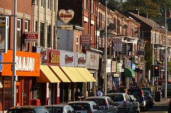
Wilmslow Road is part of the B5117, a major thoroughfare running from Parrs Wood north into the city centre transversing the campuses of the University of Manchester and Manchester Metropolitan University. It also forms part of what is the busiest bus route in Europe,[12] with many bus stops being serviced by one bus from one of many different bus companies every 60 to 90 seconds during peak times. There are a large number of Indian and Middle Eastern restaurants along a section of this road, known locally as the Curry Mile. It contains at least seventy restaurants, take-aways and kebab houses specialising in the cuisines of South Asia and the Middle East. There are also a variety of fashion, grocery and music shops along this section of the road, as well as several traditional English pubs including Hardy's Well, the Whitworth and the Huntsman Inn.
Notable people
The cricket writer and music critic Neville Cardus (1888–1975) was born in Rusholme, as were musician Roy Harper (born 1941), actors Alan Badel (1923–1982) and Tina O'Brien (born 1983), and the novelist and dramatist Ian Hay – real name John Hay Beith (1876–1952).
References
Footnotes
- ↑ "City of Manchester ward population 2011". Retrieved 5 January 2016.
- ↑ Mills 1976, p. 129
- 1 2 Sussex (1984); p.3
- ↑ Nevell, Mike (1998), Lands and Lordships in Tameside, Tameside Metropolitan Borough Council with the University of Manchester Archaeological Unit, pp. 40–41, ISBN 1-871324-18-1
- ↑ Sussex (1984); pp. 3–4
- ↑ Strutt, Edward (1892) Memorials of Mr. Thomas Lowe, of Rusholme.
- ↑ "Genealogy Data Page 164". Maris Ancestry. Retrieved 25 July 2010.
- ↑ Sussex (1984); p. 14
- 1 2 Pevsner, N. (1969) Lancashire; 1. Harmondsworth: Penguin; p. 321
- ↑ The Old Grey Whistle Test, 1985
- ↑ BBC, No author stated (2008-06-04). "Funding boost for crime unit". BBC News. BBC. Retrieved 2009-04-29.
- ↑ O'Rourke, Aidan (2006-10-26). "Oxford Rd Manchester with Stagecoach bus". EyeOnManchester. Retrieved 2007-09-03.
Bibliography
- Anderson, Bruce (2012). "Rusholme & Victoria Park Archive". Dale Street, Manchester.: author. Retrieved 19 February 2012.
- Mills, David (1976), The Placenames of Lancashire, Batsford, ISBN 0-7134-5236-6
Further reading
- Cronin, Jill & Rhodes, Frank (2006) Rusholme and Victoria Park. Stroud: Tempus ISBN 0-7524-4198-1
- Royle, William (1905) Rusholme Past and Present, being a gossipy talk of men and things. Manchester: Wm. Hough & Sons
- --do.--(1914) History of Rusholme, with a gossipy talk of men and things. Manchester: Printed at the W. Morris Press
- Royle, D. K. (1924) William Royle of Rusholme. Manchester: Sherratt & Hughes
- Sussex, Gay & Helm, Peter (1984) Looking back at Rusholme & Fallowfield. Altrincham: Willow
External links
- Rusholme – Districts & Suburbs of Manchester England
- Rusholme and Victoria Park Archive
- Friends of Platt Fields Park
- Rusholme Curry Mile Manchester
- Dynamo Bowden Athletic Football club