Rosnoën
| Rosnoën Rosloc'hen | |
|---|---|
|
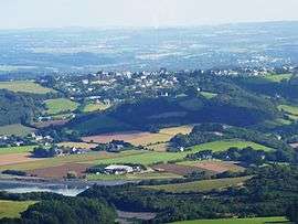
Rosnoën seen from the summit of Ménez-Hom, with the Aulne river in the foreground | |
 Rosnoën | |
|
Location within Brittany region  Rosnoën | |
| Coordinates: 48°15′51″N 4°11′36″W / 48.2642°N 4.1933°WCoordinates: 48°15′51″N 4°11′36″W / 48.2642°N 4.1933°W | |
| Country | France |
| Region | Brittany |
| Department | Finistère |
| Arrondissement | Châteaulin |
| Canton | Le Faou |
| Intercommunality | Aulne Maritime |
| Government | |
| • Mayor (2014–2020) | Mickaël Kernéis |
| Area1 | 33.70 km2 (13.01 sq mi) |
| Population (2008)2 | 977 |
| • Density | 29/km2 (75/sq mi) |
| Time zone | CET (UTC+1) |
| • Summer (DST) | CEST (UTC+2) |
| INSEE/Postal code | 29240 / 29590 |
| Elevation | 0–167 m (0–548 ft) |
|
1 French Land Register data, which excludes lakes, ponds, glaciers > 1 km² (0.386 sq mi or 247 acres) and river estuaries. 2 Population without double counting: residents of multiple communes (e.g., students and military personnel) only counted once. | |
Rosnoën (Breton: Rosloc'hen) is a commune in the Finistère department of Brittany in north-western France.
Population
Inhabitants of Rosnoën are called in French Rosnoënais.
| Historical population | ||
|---|---|---|
| Year | Pop. | ±% |
| 1793 | 1,277 | — |
| 1800 | 1,331 | +4.2% |
| 1806 | 1,341 | +0.8% |
| 1821 | 1,380 | +2.9% |
| 1831 | 1,509 | +9.3% |
| 1836 | 1,530 | +1.4% |
| 1841 | 1,652 | +8.0% |
| 1846 | 1,441 | −12.8% |
| 1851 | 1,789 | +24.1% |
| 1856 | 1,698 | −5.1% |
| 1861 | 1,768 | +4.1% |
| 1866 | 1,838 | +4.0% |
| 1872 | 1,731 | −5.8% |
| 1876 | 1,752 | +1.2% |
| 1881 | 1,679 | −4.2% |
| 1886 | 1,838 | +9.5% |
| 1891 | 1,670 | −9.1% |
| 1896 | 1,561 | −6.5% |
| 1901 | 1,537 | −1.5% |
| 1906 | 1,530 | −0.5% |
| 1911 | 1,608 | +5.1% |
| 1921 | 1,330 | −17.3% |
| 1926 | 1,340 | +0.8% |
| 1931 | 1,261 | −5.9% |
| 1936 | 1,203 | −4.6% |
| 1946 | 1,211 | +0.7% |
| 1954 | 1,019 | −15.9% |
| 1962 | 932 | −8.5% |
| 1968 | 812 | −12.9% |
| 1975 | 725 | −10.7% |
| 1982 | 692 | −4.6% |
| 1990 | 802 | +15.9% |
| 1999 | 835 | +4.1% |
| 2008 | 977 | +17.0% |
See also
References
- Mayors of Finistère Association (French)
External links
| Wikimedia Commons has media related to Rosnoën. |
- Official website (French)
- French Ministry of Culture list for Rosnoën (French)
This article is issued from Wikipedia - version of the 2/24/2015. The text is available under the Creative Commons Attribution/Share Alike but additional terms may apply for the media files.