Rocksprings, Texas
| Rocksprings, Texas | |
|---|---|
| City | |
|
Historic Rocksprings Hotel | |
 Location of Rocksprings, Texas | |
 | |
| Coordinates: 30°0′58″N 100°12′32″W / 30.01611°N 100.20889°WCoordinates: 30°0′58″N 100°12′32″W / 30.01611°N 100.20889°W | |
| Country | United States |
| State | Texas |
| County | Edwards |
| Area | |
| • Total | 1.22 sq mi (3.15 km2) |
| • Land | 1.22 sq mi (3.15 km2) |
| • Water | 0.0 sq mi (0.0 km2) |
| Elevation | 2,402 ft (732 m) |
| Population (2010) | |
| • Total | 1,182 |
| • Density | 973/sq mi (375.5/km2) |
| Time zone | Central (CST) (UTC-6) |
| • Summer (DST) | CDT (UTC-5) |
| ZIP code | 78880 |
| Area code(s) | 830 |
| FIPS code | 48-62816[1] |
| GNIS feature ID | 1345423[2] |

Rocksprings is a town in Edwards County, Texas, in the United States. As of the 2010 census, the town population was 1,182,[3] down from 1,285 at the 2000 census. It is the county seat of Edwards County.[4] The town received its name from natural springs that bubble forth from the porous limestone rocks in the area.
History
J. R. Sweeten sited Rocksprings in 1891 because of the springs nearby. Also in 1891, the town acquired a post office and was made county seat. The original courthouse built in the town burned in 1897. By 1914 Rocksprings had a population of around 500.
On April 12, 1927, the town was hit by an F5 tornado that destroyed 235 of the 247 buildings in the town. The tornado killed 72 townspeople and injured 205, almost 1/3 of the population at the time.[5]
Geography
Rocksprings is located northeast of the center of Edwards County at 30°0′58″N 100°12′32″W / 30.01611°N 100.20889°W (30.016161, -100.209023).[6] Rocksprings sits on top of the Edwards Plateau. According to the United States Census Bureau, the town has a total area of 1.2 square miles (3.1 km2), all of it land.[3]
U.S. Route 377 passes through the center of the town, leading northeast 46 miles (74 km) to Junction and southwest 76 miles (122 km) to Del Rio. Texas State Highway 55 joins US 377 as Main Street through Rocksprings, but leads northwest 55 miles (89 km) to Sonora and south 68 miles (109 km) to Uvalde.
Climate
The climate in this area is characterized by hot, humid summers and generally mild to cool winters. According to the Köppen Climate Classification system, Rocksprings has a humid subtropical climate, abbreviated "Cfa" on climate maps.[7]
Economy
The economy of Rocksprings is centered on the wool and mohair industry, and the town is recognized as the Angora goat capital of the world. Tourism has become a growing part of the economy with the opening of Devil's Sinkhole State Natural Area located approximately 8 miles (13 km) northeast of Rocksprings.
Demographics
| Historical population | |||
|---|---|---|---|
| Census | Pop. | %± | |
| 1930 | 998 | — | |
| 1940 | 1,339 | 34.2% | |
| 1950 | 1,436 | 7.2% | |
| 1960 | 1,182 | −17.7% | |
| 1970 | 1,221 | 3.3% | |
| 1980 | 1,317 | 7.9% | |
| 1990 | 1,339 | 1.7% | |
| 2000 | 1,285 | −4.0% | |
| 2010 | 1,182 | −8.0% | |
| Est. 2015 | 1,116 | [8] | −5.6% |
As of the census[1] of 2000, there were 1,285 people, 420 households, and 312 families residing in the town. The population density was 1,064.1 people per square mile (410.0/km²). There were 535 housing units at an average density of 443.0 per square mile (170.7/km²). The racial makeup of the town was 76.26% White, 1.17% African American, 0.93% Native American, 0.16% Asian, 18.75% from other races, and 2.72% from two or more races. Hispanic or Latino of any race were 66.69% of the population.
There were 420 households out of which 40.2% had children under the age of 18 living with them, 58.3% were married couples living together, 11.7% had a female householder with no husband present, and 25.5% were non-families. 23.1% of all households were made up of individuals and 11.9% had someone living alone who was 65 years of age or older. The average household size was 2.99 and the average family size was 3.58.
In the town the population was spread out with 33.5% under the age of 18, 8.3% from 18 to 24, 25.6% from 25 to 44, 20.5% from 45 to 64, and 12.1% who were 65 years of age or older. The median age was 32 years. For every 100 females there were 105.3 males. For every 100 females age 18 and over, there were 99.3 males.
The median income for a household in the town was $19,970, and the median income for a family was $22,614. Males had a median income of $21,369 versus $14,408 for females. The per capita income for the town was $8,957. About 31.7% of families and 38.2% of the population were below the poverty line, including 51.6% of those under age 18 and 16.8% of those age 65 or over.
Education
The town is served by the Rocksprings Independent School District and home to the Rocksprings High School Angoras. The school mascot is Rocko, the fighting Angora goat.
Photo gallery
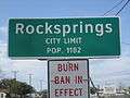 Entrance sign to Rocksprings; burn ban in effect in 2011
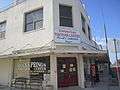 Rocksprings Visitor Center arranges tours of the nearby Devil's Sinkhole State Natural Area.
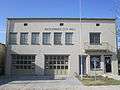 Rocksprings City Hall
 Edwards County Courthouse
 First Methodist Church in Rocksprings
References
- 1 2 "American FactFinder". United States Census Bureau. Retrieved 2008-01-31.
- ↑ "US Board on Geographic Names". United States Geological Survey. 2007-10-25. Retrieved 2008-01-31.
- 1 2 "Geographic Identifiers: 2010 Census Summary File 1 (G001): Rocksprings town, Texas". American Factfinder. U.S. Census Bureau. Retrieved March 25, 2016.
- ↑ "Find a County". National Association of Counties. Retrieved 2011-06-07.
- ↑ Cox, Mike. Texas Disasters: True Stories of Tragedy and Survival. Globe Pequot Press, Sep. 2006. pp 99-108.
- ↑ "US Gazetteer files: 2010, 2000, and 1990". United States Census Bureau. 2011-02-12. Retrieved 2011-04-23.
- ↑ Climate Summary for Rocksprings, Texas
- ↑ "Annual Estimates of the Resident Population for Incorporated Places: April 1, 2010 to July 1, 2015". Retrieved July 2, 2016.
- ↑ "Census of Population and Housing". Census.gov. Retrieved June 4, 2015.
Municipalities and communities of Edwards County, Texas, United States | ||
|---|---|---|
| Town |  | |
| Unincorporated communities | ||