Rivington
| Rivington | |
 Rivington village green and stocks |
|
 Rivington |
|
| Population | 109 (2011 Census) |
|---|---|
| OS grid reference | SD626144 |
| Civil parish | Rivington |
| District | Chorley |
| Shire county | Lancashire |
| Region | North West |
| Country | England |
| Sovereign state | United Kingdom |
| Post town | BOLTON |
| Postcode district | BL6 |
| Dialling code | 01204 |
| Police | Lancashire |
| Fire | Lancashire |
| Ambulance | North West |
| EU Parliament | North West England |
| UK Parliament | Chorley |
|
|
Coordinates: 53°37′32″N 2°33′59″W / 53.6255°N 2.5664°W
Rivington is a small village and civil parish of the Borough of Chorley, Lancashire, England, occupying 2,538 acres (10.27 km2). It is about 6 miles (9.7 km) southeast of Chorley and about 8.5 miles (13.7 km) northwest of Bolton. Rivington is situated on the fringe of the West Pennine Moors, at the foot of Rivington Pike.[1] According to the United Kingdom Census 2001 it had a population of 144,[2] reducing to 109 at the 2011 Census.[3]
Life in the Middle Ages centred on the families who owned the manor in what was then an isolated rural community. Agriculture, hand loom weaving, quarrying and mining occupied the few inhabitants until the middle of the 19th century. A chapel built before 1541 was replaced by the present church in 1666 and by 1703 Nonconformism led to the building of a Presbyterian church, now a Unitarian Chapel. A grammar school was founded by charter of Queen Elizabeth I in 1556.
Construction of reservoirs for Liverpool Corporation in the mid-19th century led to a decrease in the population when farms were cleared, the valley flooded and property in the western part of the village demolished. William Lever bought the Rivington Hall estate at the turn of the 20th century and used his wealth to renovate the old barns and create a large public park.
History
Toponymy
The origin of the name Rivington is unclear, but is made up of three elements. The first element Riv- comes from either the rowan plants[4][5] or from the Old English word hreof meaning rough.[4][6] The second element -ing- usually referred to a place belonging to a person, but in the case of Rivington the element seems to have crept in over the years.[6] The last element comes from the Old English word "tun" meaning a farmstead or settlement. Together the name Rivington may mean "a settlement in the rowans" or "a rough farmstead".[4][6]
Rivington has been recorded in many ways in earlier centuries, Rowinton, Rawinton, and Revington were used in 1202; Ruhwinton in 1212, Riuiton in 1226, Rowynton and Rouynton in 1278, Roynton in 1332, Rouyngton in 1400, Revyngton although rare, and Rovington and Ryvington from the 16th century.[4][6][7]
Early history
It is possible that settlements have existed in the area around Rivington since the Bronze Age.[8] Arrowheads, a flint knife, scrapers and the remains of cremations were excavated from a Bronze Age cairn at Noon Hill in 1958 and 1963–64.[9] It is possible that the name Coblowe on the eastern bank of the Lower Rivington Reservoir derives from the Old English hlaw, a hill, which denoted an ancient barrow or burial place.[10] Evidence for the existence of a settlement here in Anglo-Saxon times is found in the Rivington and Coblowe names.
Manor
In 1212 Alexander de Pilkington held six oxgangs of land in thanage, the majority of land in the Manor of Rivington, and in 1290[11] it became home to a junior branch of the Pilkington family.[7][12] Robert Pilkington extended the original Rivington Hall in the 15th century. Rivington Hall Barn is variously dated from Saxon times to the 16th century.[13][14] Robert's son, Richard, rebuilt the chapel. Richard’s son James Pilkington, Bishop of Durham from 1560–75, founded Rivington Grammar School.
After the death of George Pilkington (1516–97), the estate passed to his son, Robert, but it was by then in decline.[7] Robert died in 1605.[15] In 1611, the Pilkingtons sold Rivington Hall estate to Robert Lever and Thomas Breres.
A quarter of the manor was owned by the Lathoms and an eighth by the Shaws. In the 18th century the Shaws sold their land to Lord Willoughby of Parham.[7] On the death of Hugh Willoughby the 15th baron in 1765 the Shaws and Roscoes inherited his estates.[16]
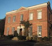
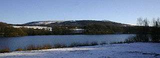
In 1729 John Andrews of Little Lever bought the Breres' share of the manor and was responsible for building the Pike Tower in 1733. His descendant, Robert Andrews, partially rebuilt Rivington Hall in red brick in the Georgian style in 1774.[17] After Andrew's death the property passed to his sister Hannah Maria Andrews, who had married Robert Fletcher of Liverpool. Their daughter, Lucy, married Woodhouse Crompton in 1834 and their descendants remained resident at the hall until 1910.[7] In 1900 the Cromptons sold their interest in the manor and estate of 2,169 acres (8.78 km2)[18] to William Hesketh Lever.[7] The Rivington Hall estate was acquired by compulsory purchase by Liverpool Corporation in 1902 as part of the reservoir scheme. William Lever created a 364-acre (1.47 km2)[18] park to the north of the reservoir, Lever Park. He donated the park to the town of Bolton and after his death the park was owned by Liverpool Corporation. The land is owned by United Utilities.[13]
Industries
Foundations of a building that was perhaps a water mill or the manor corn mill are to be found opposite Mill Hill Cottages next to where a possible mill pond was shown on the 1848 first edition Ordnance Survey map.
Until the 19th century Rivington was a rural village built around what is now the village green. Its inhabitants were employed in agriculture on scattered local farms, hand loom weaving in their own homes, working in the local quarries or the small coal mines on Winter Hill.[7][19] Wilderswood Colliery, owned by Nicholas Fish, appeared in the 1869 Mines List.[20] Coal mining was on a very small scale;[20] in 1896 the Rivington Moor Colliery employed two workers mining coal from the Mountain coal seam for own or local use.[21]
At Tiger's Clough, in the River Douglas valley, close to the boundary with Horwich, the Knoll Bleachworks and a calico-printing works were operating before 1800.[7] They were demolished by Liverpool Corporation as part of the reservoir scheme in the 1860s.[22]
Reservoirs
Rivington was dramatically changed by the construction of the Anglezarke, Upper Rivington, Lower Rivington and Yarrow reservoirs which were built to provide Liverpool with a safe, clean water supply. Nine properties in the valley were demolished before construction work began. The Rivington Pike Scheme, still in use today, was undertaken by Thomas Hawksley between 1850 and 1857. The scheme was to construct five reservoirs and a water treatment works at the south end of Lower Rivington with a 17-mile (27 km) pipeline to storage reservoirs at Prescot. Water from two higher level reservoirs, Rake Brook and Lower Ruddlesworth, was carried south in the Goit, a man-made channel connecting them to the lower reservoirs. The scheme was expanded in 1856, to include High Bullough Reservoir, built in 1850 by J. F. Bateman to supply water to Chorley. The scheme was further expanded by the construction of the Upper Roddlesworth Reservoir in 1867–75 by Thomas Duncan and Joseph Jackson.[23] Yarrow Reservoir, on which work began in 1867, was designed by Thomas Duncan, the Liverpool Borough Engineer.[24]
In 1900 Liverpool Corporation attempted to acquire the entire area to safeguard its water supply, and proposed to demolish the entire village. Some buildings were protected and others left vulnerable in an Act of Parliament known as the Liverpool Corporation Act 1902.[25] This allowed the corporation to acquire by compulsory purchase properties in the west of the village, including the Black-a-Moors Head public house and the New Hall, which were demolished between 1902 and 1905. The result was the small settlement that has remained largely unchanged since then.
Governance
Rivington was a township in the ecclesiastical parish of Bolton le Moors, in the Salford hundred in Lancashire.[26] It became part of the Chorley Poor Law Union, formed in 1837, and took responsibility for the administration and funding of the Poor Law in that area.[27] In 1866 Rivington became a civil parish. It became part of the Chorley Rural Sanitary District from 1875 to 1894, and part of the Chorley Rural District from 1894 to 1974.[28]
Since 1974 Rivington has been a civil parish of the Borough of Chorley, which comprises 47 councillors each elected for 4-year terms to represent wards in the borough. In May 2010 the constitution of the Chorley council was Conservatives had 27 seats, Labour 15 seats, Liberal Democrats 3 seats and Independents 2 seats. Rivington is part of the Heath Charnock and Rivington ward and in 2010 elected a Conservative councillor, Pat Case, CBE, who is deputy leader of the council.[29] Chorley is part of the Lancashire County Council created in 1889 under the Local Government Act 1888 and reconstituted under the Local Government Act 1972. Rivington is part of the Chorley Rural East ward.[30]
Rivington is part of the Chorley parliamentary constituency, which elected Lindsay Hoyle as Member of Parliament for the Labour party at the 2010 General Election.[31]
Geography
| Rivington | ||||||||||||||||||||||||||||||||||||||||||||||||||||||||||||
|---|---|---|---|---|---|---|---|---|---|---|---|---|---|---|---|---|---|---|---|---|---|---|---|---|---|---|---|---|---|---|---|---|---|---|---|---|---|---|---|---|---|---|---|---|---|---|---|---|---|---|---|---|---|---|---|---|---|---|---|---|
| Climate chart (explanation) | ||||||||||||||||||||||||||||||||||||||||||||||||||||||||||||
| ||||||||||||||||||||||||||||||||||||||||||||||||||||||||||||
| ||||||||||||||||||||||||||||||||||||||||||||||||||||||||||||
Rivington is situated on the moorland fringe between the high unenclosed moorland of the West Pennine Moors and the fields below. The landscape is characterised by marginal pastures with isolated farmsteads, reservoirs and disused mines and quarries scattered across the hillsides. There is an extensive network of footpaths providing public access.[33] The reservoir valleys are dominated by expanses of water and the Victorian gothic architecture of the dams and embankments surrounded by woodland.[34]
To the east of Rivington is Rivington Pike and to the west the flatter land of the Lancashire Plain. Rivington is north of Horwich and Bolton and to the south of Anglezarke Moor and Yarrow Reservoir. To the west of the village is the wide shallow valley containing the Anglezarke, Upper and Lower Rivington reservoirs. The village is accessed from the west by a road on top of the 876-foot (267 m) long Horrobin Embankment, a dam that separates the Upper and Lower Rivington reservoirs.[24] The River Douglas has its source on Winter Hill, and flows in a southwest direction forming part of the southern boundary. The River Yarrow has its source on Anglezarke Moor and forms the northern boundary.[7] The area of the township is 2,768 acres (11.20 km2), the reservoirs and filter beds occupy 275 acres (1.11 km2).[35]
The underlying geology is Millstone Grit overlaid with coal measures. Gritstone was quarried for building stone in the area. Around Rivington are chalybeate springs and in Dean Wood is a waterfall with a descent of 32 feet (9.8 m).[19]
 |
Chorley | Anglezarke, Anglezarke Reservoir | West Pennine Moors | |
| Upper and Lower Rivington Reservoirs, M61 motorway | |
Winter Hill, Belmont, Sharples | ||
| ||||
| | ||||
| Adlington, Anderton, Grimeford Village | Blackrod, Horwich | Bolton |
Demography
In 2001, 144 people lived in Rivington, 63 males and 81 females.[36] There were 48 households of which 34 lived in detached houses and 14 in terraced or semi-detached properties. Most households, 60%, were owner-occupied; the remainder were privately rented.[37] The mean age of the population was 53.4 years.[38] In 2001 most of those employed, 47, worked in the service industries. Ten worked in extractive and manufacturing industries, and three males were unemployed. The average distance travelled to work by employed persons was 20.5 km.[39]
Population change
| Population changes in Rivington since 1801 | |||||||||||||||||||||||||||||||||||||||||||||||||||||||||||||||||||||||
|---|---|---|---|---|---|---|---|---|---|---|---|---|---|---|---|---|---|---|---|---|---|---|---|---|---|---|---|---|---|---|---|---|---|---|---|---|---|---|---|---|---|---|---|---|---|---|---|---|---|---|---|---|---|---|---|---|---|---|---|---|---|---|---|---|---|---|---|---|---|---|---|
|
|
| |||||||||||||||||||||||||||||||||||||||||||||||||||||||||||||||||||||
Economy

In the 19th century farming became less economic when construction of the reservoirs reduced the amount of agricultural land in the village. The weaving industry was mechanised, small mines closed and the population declined further when properties in the village were demolished in the early 20th century.[8] Agriculture, mainly sheep farming, continues although on a small scale. Tourism at Rivington began in Victorian times and after the reservoirs were filled in the 1860s was known as the Little Lake District. Rivington became a popular destination when Lever Park opened in 1904. From the late Victorian period until the mid-20th century tourists from Bolton travelled on day trips by tram along Chorley New Road and then on to Rivington on foot, many more visitors arrived by train.[43] Today thousands of visitors are attracted to the village, Rivington Pike and Lever Park every year, making tourism the most significant source of income in the area.[8]
Transport
Rivington is to the east to the M61 motorway, which connects the M6 and Preston to the north with the M60 and the Greater Manchester conurbation to the south. The nearest access is at Junction 6. The village is accessed by minor roads from Horwich to the south and Adlington to the west. A winding road to the north passes through Anglezarke and a road over the moors to the east leads to Belmont. The nearest places with regular bus services are Horwich to the south and Adlington to the west, which are served by buses between Bolton and Chorley or Preston.
The arrival of the Manchester and Bolton Railway's extension to Preston and opening of Blackrod railway station in 1841 brought visitors to the area. The line remains open with stations at Blackrod and Horwich Parkway giving access to Bolton, Manchester, Chorley and Preston.[44]
Education

Rivington Grammar School's charter was granted to James Pilkington by Queen Elizabeth I in 1566. The school opened in 1575 and was rebuilt in 1714. Blackrod Grammar School, founded in 1568, merged with it in 1875. In 1882 Rivington & Blackrod Grammar School opened on a site at the south of the township, close to the boundary with Horwich. The school is now Rivington and Blackrod High School, a specialist technology college, focusing on design and technology, mathematics and science. Year Seven pupils occupy the former Horwich County Secondary School.[45]
The old grammar school building in the village centre is now occupied by Rivington Foundation Primary School.[46][47]
Religion

Rivington was a chapelry in the ancient ecclesiastical parish of Bolton le Moors until it became a parish in its own right in 1856. Rivington Church is built on a hill known as Chapel Croft.[48] An earlier chapel on this site was named in a deed by Margaret Pilkington and her son Robert in 1476. The parochial chapelry covered Rivington and the surrounding areas of Anglezarke, Hemshaws and Foulds. In 1628 a chapel was built "upon a little toft and quillet of land" by the local population and where divine service was celebrated "for many years of antiquity".[7] The early 16th century chapel was rebuilt in 1666 and altered and restored during the late 19th century.[49] It is a small plain building built in sandstone with a bell turret. It is an Anglican church and is unusual in that it is not dedicated to any saint or martyr, referred to simply as Rivington Church.[50]
Rivington Unitarian Chapel was built with a bellcote of local stone in 1703. Originally founded as a Presbyterian church and became Unitarian in the late 18th century.[51] The chapel, which retains its box pews, was restored in 1990.[52] Both churches are listed buildings and active places of worship.
Landmarks
Rivington conservation area
There are a number of listed buildings in Rivington, most of which have Grade II, but two have the higher Grade II* status. They are spread throughout the village and Lever Park, and include the tower on top of Rivington Pike.[53][54]
There are eight listed properties in the Rivington conservation area, almost half of the houses in the village. Listed buildings include the former vicarage, the Manse House and a row of cottages, one of which was the post office, two rows of cottages at Mill Hill and Pilkington's Farmhouse, all of which are private residences. Rivington Church and the Unitarian Chapel are active places of worship; the former grammar school is now a primary school.[8][55]
The village stocks on the green are inscribed "T W 1719" on the stone base. The churchwarden and village constable patrolled the village and anyone disregarding the sanctity of the sabbath would be bound in them.[56]
Outside the village centre, the Georgian Rivington Hall, the adjacent Hall Barn and Great House Barn, which is possibly a tithe barn, are all listed buildings.[57][58] Great House Farm now houses an information centre.[59]
Lever Park
Lever Park is a designed landscape between the open moorland and the chain reservoirs which incorporates the village and buildings of Rivington into the overall design and is "one of the largest and most impressive examples of landscape design in Edwardian England". It is of national importance and historical significance but has been neglected and has deteriorated.[60] Situated on the east bank of the Lower Rivington reservoir, the park is named after William Lever, Lord Leverhulme,[61] who bought the estate in 1900 and donated 364 acres (1.47 km2)[62] of land to the people of his native Bolton as a public park. Under the terms of a compulsory purchase order, William Lever was allowed to continue with plans to lay out Lever Park at his own expense, and he maintained it during his lifetime. The park opened in 1904 and contained a boating lake, a zoo, tree-lined avenues and a network of footpaths. A folly, Rivington Castle, was built as a scale replica of Liverpool Castle at Coblowe Hillock near the Lower Rivington Reservoir.[63] Lodges were built at the entrances to the estate, including Stone House Lodge at the main driveway.

Roynton Cottage, originally a single-storey wooden bungalow, and its extensive gardens were the private property of William Lever, which he used for weekend visits and entertaining, high on the hillside below Rivington Pike.[61][64] The bungalow was destroyed in an arson attack by suffragette, Edith Rigby, on 8 July 1913.[65] Its replacement was built of stone. Thomas Mawson designed the 45-acre (180,000 m2) gardens between 1905 and 1922.[66] The private gardens contained terraces and a pool, a Japanese lake and pagoda, Italian-style gardens, a seven-arched bridge and the Pigeon Tower with Lady Leverhulme's sewing room on the top floor.[67]
After Lever's death Roynton Cottage was acquired by the Bolton brewer, John Magee. During the Second World War the bungalow was requisitioned to be used as a billet for troops, and nissen huts were erected in the grounds. After the war the site was acquired by Liverpool Corporation, who decided to demolish the building.
In 1974 the park and gardens passed to the North West Water Authority from Liverpool Corporation, and to United Utilities on privatisation, and are maintained as a public country park for the people of Bolton, protected by rights afforded by the Liverpool Corporation Act 1902 ensuring "Free and uninterrupted enjoyment by the public".[68] The listed historic landscape of Lever Park now forms part of Rivington County Park and is used for recreation.
Sport
The Rivington Pike Fell Race has been held on Easter Saturday since 1892. The fell race originally started from the Horwich railway works, but since 1930 from the park entrance at Lever Park Avenue. It now attracts around 400 runners. The course is 3.25 miles (5.2 km) and there is a 700-foot (213 m) ascent.[69][70]
The area around Rivington and Anglezarke was the location for the 2002 Commonwealth Games mountain biking competition.[71] The area is well used by hikers and hillwalkers. The Holcombe Hunt meets each year at Rivington Hall Barn.[72]
See also
References
Notes
- ↑ Rivington Township Boundaries, GenUKI, retrieved 6 June 2010
- 1 2 "Area: Rivington (Parish): Key Figures for 2001 Census: Key Statistics". Neighbourhood Statistics. Office for National Statistics. Retrieved 16 January 2016.
- 1 2 "Area: Rivington (Parish): Key Figures for 2011 Census: Key Statistics". Neighbourhood Statistics. Office for National Statistics. Retrieved 16 January 2016.
- 1 2 3 4 Smith 1989, p. 4
- ↑ Rivington, bolton.org.uk, retrieved 2 June 2010
- 1 2 3 4 Billington 1982, pp. 68–69
- 1 2 3 4 5 6 7 8 9 10 Farrer & Brownbill 1911, pp. 286–294
- 1 2 3 4 "Rivington Conservation Area Appraisal and Management Proposals" (PDF). Chorley Council. Retrieved 7 June 2010.
- ↑ Noon Hill, Pastscape, retrieved 16 July 2010
- ↑ Irvine 1904, p. xv
- ↑ Pilkington 1912, pp. 28–29
- ↑ Horrox, Rosemary (2004), "Pilkington family (per. c.1325–c1500), gentry", Oxford Dictionary of National Biography, Oxford University Press, retrieved 27 June 2010 (subscription required)
- 1 2 Rivington, United Utilities, retrieved 6 August 2010
- ↑ Rivington Hall Barn, Images of England, retrieved 6 August 2010
- ↑ Pilkington 1912, p. 120
- ↑ Shaw 1940, pp. 133–134
- ↑ Rivington Hall, Images of England, retrieved 6 August 2010
- 1 2 Pilkington 1912, p. 189
- 1 2 Lewis, Samuel (1848), "Rivington or Rovington", A Topographical Dictionary of England, British History Online, pp. 676–679, retrieved 4 June 2010
- 1 2 Collieries at work in1869, Coal Mining History Resource Centre, retrieved 7 July 2009
- ↑ North and East Lancashire's Mining Industry in 1896, projects.exeter.ac.uk, retrieved 7 July 2009
- ↑ Lane 2008, p. 12
- ↑ Rivington Reservoirs, Pastscape, retrieved 17 June 2010
- 1 2 Rivington Reservoirs (main scheme), Engineering Timelines, retrieved 4 June 2010
- ↑ "Liverpool Corporation Act, 1902." (PDF). Office of Public Sector Information (OPSI). Retrieved 24 June 2010.
- ↑ Rivington, GenUKI, retrieved 3 June 2010
- ↑ Workhouse, Workhouses.org, retrieved 4 June 2010
- ↑ Relationships / unit history of Rivington, Vision of Britain, retrieved 4 June 2010
- ↑ Chorley Council, Democracy, Chorley Council, retrieved 2 June 2010
- ↑ County Councillors by Local Community, Lancashire County Council, retrieved 2 June 2010
- ↑ Election Results 2010, bbc.co.uk, retrieved 5 June 2010
- ↑ Rivington Weather, United Kingdom Weather Averages, retrieved 23 September 2012
- ↑ Moorland Fringe, Lancashire County Council, retrieved 21 September 2010
- ↑ Reservoir Valleys, Lancashire County Council, retrieved 21 September 2010
- ↑ Smith & 1984 p.40
- ↑ "Rivington CP (Parish)", Neighbourhood Statistics, Office for National Statistics, retrieved 30 June 2010
- ↑ "Parish Profile - Accommodation and Tenure", Neighbourhood Statistics, Office for National Statistics, retrieved 10 November 2010
- ↑ Parish Profile - People, Office for National Statistics, retrieved 10 November 2010
- ↑ "Parish Profile - Work and Qualifications", Neighbourhood Statistics, Office for National Statistics, retrieved 10 November 2010
- ↑ Tatton, Pauline. Local population statistics 1801–1986, Bolton Central Library Archives, Le Mans Crescent, Bolton.
- ↑ Rivington SubD Population. A vision of Britain through time. Retrieved 4 June 2010.
- ↑ Rivington CP/Ch. Population. A vision of Britain through time. Retrieved 4 June 2010.
- ↑ Rawlinson 1966, p. 93
- ↑ Horwich Parkway (HWI), National Rail, retrieved 30 June 2010
- ↑ Welcome to Rivington & Blackrod High School, Rivington and Blackrod High School, retrieved 24 April 2008
- ↑ Rivington Foundation Primary School, LancashireCounty Council, retrieved 6 March 2010
- ↑ Schools, Adlington Information, retrieved 6 March 2010
- ↑ Rivington Churches, rivington-lancashire.com, retrieved 10 June 2010
- ↑ Rivington Church, Lancashire Online Parish Clerks, retrieved 10 June 2010
- ↑ Rivington Church, GenUKI, retrieved 3 June 2010
- ↑ Rivington Chapel, GenUKI, retrieved 3 June 2010
- ↑ Rivington Unitarian Chapel, Unitarian.org, retrieved 4 June 2010
- ↑ Listed Buildings in Rivington, Listed Buildings Online, retrieved 21 June 2010
- ↑ Chorley Borough Council Listed Buildings, Chorley Council, retrieved 21 June 2010
- ↑ "Map of Conservation Area" (PDF). Chorley Council. Retrieved 7 June 2010.
- ↑ Hampson, Thomas (1893). History of Rivington: With Lists of the Clergy and Church Wardens, the Church Wardens Accounts, Particulars of the Rivington and Blackrod Grammer. p. 130.
- ↑ "Listed buildings". Chorley Council. Retrieved 30 May 2010.
- ↑ "List of listed buildings" (PDF). Chorley Council. Retrieved 30 May 2010.
- ↑ Rivington Information Centre, United Utilities, retrieved 20 June 2010
- ↑ Crosby, Dr Alan G., West Pennine Moors (pdf), West Pennine Moors area management committee, pp. 41–42, retrieved 22 December 2010
- 1 2 Smith 1984, p. 22
- ↑ Pilkington 1912, pp. 189
- ↑ Lever Park, Rivington, Parks and Gardens UK, retrieved 6 June 2010
- ↑ Waymark 2009, p. 80
- ↑ Preston's Blue Plaques, Edith Rigby, Preston Council, archived from the original (pdf) on 28 September 2011, retrieved 21 June 2010
- ↑ Smith 1984, p. 40
- ↑ Waymark 2009, pp. 77–81
- ↑ Rivington Gardens, Parks and Gardens UK, retrieved 6 June 2010
- ↑ Running Diary, Running Diary, retrieved 2 June 2010
- ↑ Cornthwaite grabs success at Rivington Pike Fell Race, Lancashire Telegraph, retrieved 2 June 2010
- ↑ 2002 Commonwealth Games, TheCGF, retrieved 4 June 2010
- ↑ Holcombe Hunt, The Holcombe Hunt, retrieved 27 September 2010
Bibliography
- Billington, W. D. (1982), From Affetside to Yarrow, Ross Anderson Publications, ISBN 0-86360-003-4
- Farrer, William; Brownbill, J., eds. (1911), "Rivington", A History of the County of Lancaster: Volume 5, British History Online
- Irvine, William Fergusson (1904), A short history of the township of Rivington, Edinburgh: Ballantyne Press
- Lane, Dave (2008), Winter Hill Scrapbook, Lulu, ISBN 978-1-4092-2068-8
- Pilkington, James (1912), The History of the Pilkington family and its branches, from 1066 to 1600 (Third ed.), Liverpool: C. Tinley & Co. Ltd
- Shaw, Ronald Cunliffe (1940), The Records of a Lancashire Family from the XIIth to the XXth Century [On the Shaw family. With plates and genealogical tables.], Preston: Guardian Press
- Rawlinson, John (1969), About Rivington, Nelson
- Smith, M. D. (1984), Leverhulme's Rivington: the story of the Rivington 'Bungalow', Chorley: Nelson Brothers Printers, ISBN 0-9508772-1-2
- Smith, M. D. (1989), Rivington, Lancashire, Nelson Brothers Printers Limited, ISBN 0-9508772-8-X
- Waymark, Janet (2009), Thomas Mawson: Life, Gardens and Landscapes, Frances Lincoln, ISBN 978-0-7112-2595-4
Further reading
- Hesketh, Phoebe (1972), Rivington: the story of a village, London: Peter Davies, ISBN 0-432-06681-0
External links
| Wikimedia Commons has media related to Rivington. |