Ritchie's Archipelago
| Nickname: John Ritchie's Archipelago | |
|---|---|
 Ritchie's Archipelago  Ritchie's Archipelago | |
| Geography | |
| Location | Bay of Bengal |
| Coordinates | 12°03′N 93°01′E / 12.05°N 93.02°ECoordinates: 12°03′N 93°01′E / 12.05°N 93.02°E |
| Archipelago | Andaman Islands |
| Adjacent bodies of water | Indian Ocean |
| Total islands | 20 |
| Major islands | |
| Area | 252.1 km2 (97.3 sq mi)[1] |
| Highest elevation | 100 m (300 ft)[2] |
| Administration | |
| District | South Andaman |
| Island group | Andaman Islands |
| Tehsil | Port Blair Tehsil |
Largest settlement |
Govinda Nagar |
| Demographics | |
| Demonym | Hindi |
| Population | 9355 (2011) |
| Pop. density | 37.1 /km2 (96.1 /sq mi) |
| Ethnic groups | Hindu, Andamanese |
| Additional information | |
| Time zone | |
| PIN | 7442xx[3] |
| Telephone code | 031927 [4] |
| Official website |
www |
| ISO Code | IN-AN-00[5] |
| Literacy | 84.4% |
| Avg. summer temperature | 30.2 °C (86.4 °F) |
| Avg. winter temperature | 23.0 °C (73.4 °F) |
| Sex ratio | 1.2♂/♀ |
| unit_pref | Metric |
| Census Code | 35.639.0004 |
| Official Languages | Hindi, English |
Ritchie's Archipelago is a cluster of smaller islands which lie 20 km (12 mi) east of Great Andaman, the main island group of the Andaman Islands. The Islands belong to the South Andaman administrative district, part of the Indian union territory of Andaman and Nicobar Islands.[6]
Etymology
The archipelago is named after an 18th-century British marine surveyor, John Ritchie, who spent nearly two decades in the employ of the Council of Bengal charting and documenting the Andaman's and surrounding regions. The individual islands are largely named after British generals and civil officials serving in India at the time of the Indian Rebellion of 1857.
Of the archipelago which now bears his name, Ritchie's accounts and maps were the first reliable sources of information on the islands, which until then were very sketchily known to Europeans. Ritchie was one who championed that the British administration in India make further investigation and use of the Andamans. During Ritchie's time these entreaties were largely ignored. Perhaps frustrated and disillusioned after years of thankless work under difficult circumstances, Ritchie requested to be returned for home leave, which he was in 1787. An extract from his parting note to his superiors explained:
"The condition of my health being such as requires an immediate change of climate... after a series of 19 years continuous service in the office of Marine Surveyor, I hope there is no impropriety in my requesting the favour, also... to continue my allowance to me... It is a small salary, and the receipt of it has been the only advantage I have ever reaped from the Company's service, and because my Line of Service, from its singularity, has had no gradation of advancement... whilst its Duties have been uncommonly severe, uncommonly hazardous, and equally unprofitable; for what advantage could be obtained from tracking a Labyrinth of Woods and Rivers? Or from exploring the Shoals of a shelving and broken Sea Coast? All of which uninhabited, and seldom visited, except perhaps in the disastrous case of shipwreck... In the meantime it has been from my Labours, that the Hon'ble Company have obtained all authentic knowledge of the Sea Coast and Tide Rivers of their possessions in Bengal, together with other services more important and beneficial."[7]
Two years after Ritchie's departure, an attempt was made to set up a colony in the Andamans, but this was aborted after only a few years. It was not until 1867 that a permanent European presence was established, when the whole islands were annexed by the British and a penal colony established at Ross Island on South Andaman Island.
Geography
the islands are located in the Bay of Bengal, bordering with the Andaman Sea and are some 400 km (250 mi) south of the nearest Asian mainland, Cape Negrais in Myanmar. The archipelago comprises 4 larger islands, 3 medium islands, and 10 smaller islands and islets, extending in a roughly north-south chain, parallel to the main Great Andaman group. Baratang Island and South Andaman Island lie to the west across Diligent Strait; the active volcano Barren Island is 85 km (53 mi) further to the east.
The islands of Ritchie's Archipelago run in a closely spaced arc which extends about 60 km (37 mi) from the southern-most Rose Island. to North Button I., with Diligent Strait between them and Great Andaman ranging from 30 km (19 mi) to less than 10 km (6.2 mi). Most of the islands are clustered closely together separated by only narrow, almost river-like channels. The exceptions are Rose Island and Neill Island to the south of Havelock Island, and the three small Button islands which are smaller outliers to the north of the group.
The interior of most of the islands consists of undulating hills and plains, with a topography not exceeding 100 m (330 ft) above mean sea level. Occasionally the land rises reasonably abruptly from the sea to a domed plateau, and there are a few rocky coastal cliffs; however, in the main the coastlines are relatively flat, interspersed by both rocky and sand beaches and some low-lying lagoons and estuaries on the larger islands. Coral reefs surround many of the islands, particularly on the "sea-ward" (i.e., eastern) coastlines.
Havelock, John Lawrence, Henry Lawrence, Peel and Outram Is. have a few tidal creeks winding into their interiors; in general freshwater streams are few.
Islands
The main islands in the archipelago (in decreasing order of approximate size) are:
- Havelock Island - 92.2 km2 (35.6 sq mi)
- Henry Lawrence Island - 54.7 km2 (21.1 sq mi)
- John Lawrence Island - 34.8 km2 (13.4 sq mi), formerly inhabited
- Peel Island - 23.7 km2 (9.2 sq mi)
- Wilson Island - 14.3 km2 (5.5 sq mi)
- Outram Island - 13.9 km2 (5.4 sq mi)
- Neill Island - 13.7 km2 (5.3 sq mi)
Administration
Politically, Ritchie's Archipelago is part of Port Blair Taluk.[8]
Demographics
The islands were originally populated by the indigenous Great Andamanese peoples, in particular the tribal and linguistic grouping known as Aka-Bale. However, as the populations of the various Andamanese indigenous peoples declined greatly in the decades following the establishment of colonial settlements by the British Raj (and later, independent India), the indigenous communities of these islands have vanished. The present population of the islands consists of immigrant Indian and a few Karen (Burmese) settlers. The 2011 census of India reported 9,355 people living on two inhabited islands of Ritchie's Archipelago: Havelock Island and Neill Island.
Transportation
Port Blair, is located approximately 40 km (25 mi) to the southwest of the archipelago, accessible via a 3-5 hour ferry trip.
Image gallery
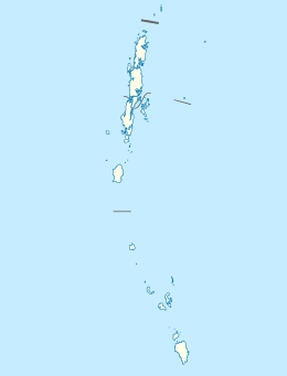
 Outline map of the Andaman Islands, with Ritchie's Archipelago highlighted (in red).
 Beach view on Havelock Island
 A beach on Neill Island
References
- ↑ "Islandwise Area and Population - 2011 Census" (PDF). Government of Andaman.
- ↑ "Sailing Directions (enroute) | India and the Bay of Bengal" (PDF) (173). National Geospatial-intelligence Agency, United States Government. 2014. Retrieved 2016-09-23.
- ↑ "A&N Islands - Pincodes". 22 September 2016. Retrieved 22 September 2016.
- ↑ "STD Codes of Andaman and Nicobar". allcodesindia.in. Retrieved 2016-09-23.
- ↑ Registration Plate Numbers added to ISO Code
- ↑ "Village Code Directory: Andaman & Nicobar Islands" (PDF). Census of India. Retrieved 2011-01-16.
- ↑ Ritchie overstates the "uninhabited" nature of the islands, since he was well aware of the existence of the indigenous tribes, and had spent some time in the company and direct presence of several of them
- ↑ "DEMOGRAPHIC – A&N ISLANDS" (PDF). andssw1.and.nic.in. Retrieved 2016-09-23.
| Wikimedia Commons has media related to Ritchie's Archipelago. |
 Ritchie's Archipelago travel guide from Wikivoyage
- Andaman Islands
- Rani Jhansi Marine National Park