Ridgway, Colorado
| Town of Ridgway, Colorado | |
|---|---|
| Town | |
|
Town of Ridgway | |
| Nickname(s): Gateway to the San Juans, The Town That Refused to Die | |
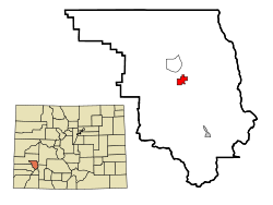 Location in Ouray County and the state of Colorado | |
| Coordinates: 38°9′7″N 107°45′25″W / 38.15194°N 107.75694°WCoordinates: 38°9′7″N 107°45′25″W / 38.15194°N 107.75694°W | |
| Country | United States |
| State | Colorado |
| County[1] | Ouray County |
| Incorporated (town) | April 2, 1891[2] |
| Named for | Robert M. Ridgway |
| Government | |
| • Type | Home Rule Municipality[1] |
| • Mayor | John I. Clark |
| • Town Manager | Jen Coates |
| Area | |
| • Total | 2 sq mi (5.2 km2) |
| • Land | 2 sq mi (5.2 km2) |
| • Water | 0 sq mi (0 km2) |
| Elevation | 6,985 ft (2,103 m) |
| Population (2010) | |
| • Total | 924 |
| • Density | 462.0/sq mi (177.7/km2) |
| Time zone | Mountain (MST) (UTC-7) |
| • Summer (DST) | MDT (UTC-6) |
| ZIP code[3] | 81432 |
| Area code(s) | 970 |
| FIPS code | 08-64200 |
| GNIS feature ID | 0188398 |
| Website | Town of Ridgway |

The Town of Ridgway, coined Gateway to the San Juans, is a Home Rule Municipality in Ouray County, in the southwestern portion of the U.S. State of Colorado. The town is a former railroad stop on the Uncompaghre River in the northern San Juan Mountains. The town population was 713 at the 2000 census and 924 according to the 2010 census.[4]
Steep forested mountains and cliffs surround Ridgway on the south, east, and northeast. The Uncompahgre River runs through the town and flows into the Ridgway State Park and Reservoir, to the north. Dallas Creek also flows from the south west and forms a confluence with the Uncompahgre before entering the reservoir. There is a notable wildlife presence — mountain lions, badgers, deer, elk, bears, coyotes, wild turkey, and bald eagles are indigenous to the area. The regions bald eagles nest in the cottonwoods along the river and are a common sight in the late fall.
Ridgway and the surrounding area have featured predominantly in pop culture. Most notably the area is the setting of John Wayne's western movie True Grit, and others including How the West Was Won and Tribute to a Bad Man. Ridgway has the only stoplight in Ouray County, at the intersection of Highways 550 and 62.[5]
History

Ridgway began as a railroad town, serving the nearby mining towns of Telluride and Ouray.
The town site is at the northern terminus of the Rio Grande Southern Railroad where it meets with Denver and Rio Grande Western Railroad running between Montrose and Ouray. Ridgway was located about 3 miles (4.8 km) south of the existing town of Dallas. Articles of incorporation were filed on May 22, 1890 and granted on March 4, 1891. This "Gateway to the San Juans" position was recognized over 100 years ago when the Rio Grande Southern established Ridgway as a railhead center servicing the nearby mining towns of Ouray and Telluride. The town was named for Denver and Rio Grande railroad superintendent Robert M. Ridgway, who established the town in 1891.[6]
The Rio Grande Southern filed for abandonment on April 24, 1952 and the Denver and Rio Grande Western abandoned the line between Ridgway and Ouray on March 21, 1953. The line between Ridgway and Montrose was upgraded from narrow gauge to standard gauge and Ridgway continued to be a shipping point until the line to Montrose was abandoned in 1976 as result of a reservoir being built on the Uncompahgre River.
The dam for that reservoir, the Ridgway Dam, was proposed in 1957 as part of the U.S. Bureau of Reclamation's Dallas Creek Project, and its original location would have inundated Ridgway. A 1975 decision to put the dam further downstream kept the town above-water, and residents coined their own nickname, "The Town that Refused to Die."[7] Land around the reservoir became the Ridgway State Park north of town limits.
Geography
Ridgway is situated in the Uncompahgre Valley at an elevation of 6,985 feet (2,129 m). The town is located on the San Juan Skyway, cradled in the heart of some of the most photographed mountains in the world. The nearby San Juan Mountain Range has 14 of Colorado's 53 peaks over 14,000 feet.[8] Among them, 14,150 feet (4,310 m) Mt. Sneffels is most prominent from Ridgway. The eponymous Mt. Ridgway, 13,468 feet (4,105 m) in height, is also nearby, 4.5 miles (7.2 km) west of Ouray.[9] To the east of the town also lies the smaller but equally-grand Cimarron Range, with Uncompahgre Peak at 14,309 feet (4,361 m).
The Uncompahgre River flows from Lake Como at 12,215 feet (3,723 m) in northern San Juan County, in the Uncompahgre National Forest in the northwestern San Juan Mountains is the headwaters of the river. It flows northwest past Ouray, Ridgway, Montrose, and Olathe and joins the Gunnison at Confluence Park in Delta. The river forms Poughkeepsie Gulch and the Uncompahgre Gorge. The major tributaries are all creeks draining the northwest San Juan Mountains. There are two dams on the Uncompahgre River, a small diversion dam in the Uncompahgre Gorge, and Ridgway Dam below the town of Ridgway, which forms Ridgway Reservoir.
The river is used for irrigation in the Uncompahgre Valley. The Uncompahgre is unnavigable, except at high water. The name given to the river comes from the Ute word Uncompaghre, which loosely translates to "dirty water" or "red water spring" and is likely a reference to the many hot springs in the vicinity of Ouray. Lake Otonawanda is the primary source of Ridgway's municipal water.[10]

| Climate data for Ridgway, Colorado | |||||||||||||
|---|---|---|---|---|---|---|---|---|---|---|---|---|---|
| Month | Jan | Feb | Mar | Apr | May | Jun | Jul | Aug | Sep | Oct | Nov | Dec | Year |
| Average high °F (°C) | 39.5 (4.2) |
42.9 (6.1) |
50.2 (10.1) |
57.3 (14.1) |
67.8 (19.9) |
78.1 (25.6) |
82.9 (28.3) |
80.4 (26.9) |
73.7 (23.2) |
62.0 (16.7) |
48.6 (9.2) |
38.9 (3.8) |
60.2 (15.7) |
| Average low °F (°C) | 5.0 (−15) |
11.3 (−11.5) |
19.3 (−7.1) |
26.1 (−3.3) |
33.0 (0.6) |
38.5 (3.6) |
45.1 (7.3) |
44.1 (6.7) |
35.6 (2) |
25.2 (−3.8) |
16.3 (−8.7) |
6.5 (−14.2) |
25.5 (−3.6) |
| Average precipitation inches (mm) | 0.86 (21.8) |
0.88 (22.4) |
1.48 (37.6) |
1.52 (38.6) |
1.53 (38.9) |
1.02 (25.9) |
2.02 (51.3) |
2.18 (55.4) |
1.79 (45.5) |
1.56 (39.6) |
1.36 (34.5) |
0.94 (23.9) |
17.14 (435.4) |
| Average snowfall inches (cm) | 12.6 (32) |
13.2 (33.5) |
17.1 (43.4) |
8.1 (20.6) |
1.6 (4.1) |
0 (0) |
0 (0) |
0 (0) |
.2 (0.5) |
3.8 (9.7) |
13.0 (33) |
15.2 (38.6) |
84.8 (215.4) |
| Source: Western Regional Climate Center[11] | |||||||||||||
Demographics
| Historical population | |||
|---|---|---|---|
| Census | Pop. | %± | |
| 1900 | 245 | — | |
| 1910 | 376 | 53.5% | |
| 1920 | 400 | 6.4% | |
| 1930 | 239 | −40.2% | |
| 1940 | 354 | 48.1% | |
| 1950 | 209 | −41.0% | |
| 1960 | 254 | 21.5% | |
| 1970 | 262 | 3.1% | |
| 1980 | 369 | 40.8% | |
| 1990 | 423 | 14.6% | |
| 2000 | 713 | 68.6% | |
| 2010 | 924 | 29.6% | |
| Est. 2015 | 977 | [12] | 5.7% |

As of the census of 2010,[14] there were 924 people, 404 households, and 256 families residing in the town. The population density was 462 people per square mile (177.7/km2). There were 511 housing units at an average density of 255.5 per square mile (98.3/km2). The racial makeup of the town was 95.5% White, 0.1% (1) African American, 0.6% (6) Native American, 0.8% (7) Asian, 0.8% (7) from other races, and 1.8% (17) from two or more races. Hispanic or Latino of any race were 5.0% of the population.
There were 404 households out of which 31.4% had children under the age of 18 living with them, 51.2% were married couples living together, 7.7% had a female householder with no husband present, 4.5% had a male householder with no wife present, and 36.6% were non-families. 28.7% of all households were made up of individuals and 4.9% had someone living alone who was 65 years of age or older. The average household size was 2.29 and the average family size was 2.82.
In the town the population was spread out with 23.3% under the age of 18, 28.6% from 18 to 44, 37.1% from 45 to 64, and 11.0% who were 65 years of age or older. The median age was 43.7 years. For every 100 females there were 94.5 males. For every 100 females age 18 and over, there were 93.7 males.
The median income for a household in the town was $40,903, and the median income for a family was $45,208. Males had a median income of $31,597 versus $26,250 for females. The per capita income for the town was $20,084. About 3.2% of families and 4.3% of the population were below the poverty line, including 6.9% of those under age 18 and none of those age 65 or over.
Tourism and culture
Ridgway is poised on a highway that leads tourists to several other mountain towns of the San Juan region. Ridgway itself is a major tourist town of Colorado. Ridgway is 37 miles east of the ski town of Telluride and 10 miles north of the tourist town of Ouray. The area is also set at the base of the San Juan Mountains providing excellent views especially when viewed from Log Hill Mesa.
The Grammy Awards
The Grammy Award trophy is hand crafted exclusively by John Billings (the 'Grammy Man') of Billings Artworks in Ridgway. The trophies are all hand made, assembled, and plated on site.
Water
Water plays an important part of local Ridgway culture. The town maintains a marina in a northern inlet of the Ridgway Reservoir. During the warm summer months many tourist and locals take advantage of the Ridgway Reservoir, often wakeboarding or enjoying a day at its beach.
The town also features Orvis Hot Springs, a clothing-optional, natural-hot-springs resort near Ridgway with an indoor, clothing-required pool.
Notable residents
Among Ridgway's population there is an assortment of recognizable and famous people.
- Charles W. "Charlie" Ergen (born May 1, 1953) is the co-founder and CEO of EchoStar Communications Corporation, the parent company of Dish Network.[15]
- Ralph Lauren (born Ralph Lifschitz on October 14, 1939) is an American fashion designer and business executive.[15][16]
- Dennis Weaver (June 4, 1924 − February 24, 2006) was an Emmy Award-winning American actor, best known for his work in television, including roles as sidekick Chester Goode from 1955 to 1964 on TV's first "adult Western" Gunsmoke, as Marshal Sam McCloud on the NBC police drama McCloud, which ran from 1970 to 1977, and as the protagonist in Steven Spielberg's feature-length directorial debut, the cult TV movie Duel in 1971.[17][18]
- Thomas H. Friedkin − Toyota king of Texas, Hollywood stunt flyer, African-game hunter − who fiercely guarded his privacy for 30 years.[19]
- Danny Thompson, American race car driver and businessman, son of the legendary Micky Thompson; known widely in the world of racing for setting multiple world records for speed at the Bonneville Salt Flats. Danny owns a fabrication company and race shop Western, Colorado, and will soon be opening up a second branch in Huntington Beach, California. He resides on Log Hill Mesa with his wife.
- Jo Fultz, American painter and educator.
- Peter Hessler (b. June 14, 1969) − Writer and journalist; notable for his writings at The New Yorker and contributions to National Geographic (magazine), as well as three books.
- PattiSue Plumer Olympic distance runner and American record holder, went to junior high school and high school in Ridgway.[20]
Transportation
The closest airport served by scheduled airlines is Montrose Regional Airport, located 28 miles north.
Major highways
 U.S. Highway 550 begins 27 miles north of Ridgway, in Montrose. It runs to Bernalillo, New Mexico, near Albuquerque, New Mexico via Durango, Colorado.
 State Highway 62 is a 23.4 miles long highway, connecting Ridgway to State Highway 145, near Placerville.
See also
References
- 1 2 "Active Colorado Municipalities". State of Colorado, Department of Local Affairs. Archived from the original on November 23, 2010. Retrieved 2007-09-01.
- ↑ "Colorado Municipal Incorporations". State of Colorado, Department of Personnel & Administration, Colorado State Archives. 2004-12-01. Retrieved 2007-09-02.
- ↑ "ZIP Code Lookup". United States Postal Service. Archived from the original (JavaScript/HTML) on December 14, 2006. Retrieved December 24, 2007.
- ↑ Colorado Trend Report 2: State and Complete Places (Sub-state 2010 Census Data). Missouri Census Data Center. Accessed 2011-02-25.
- ↑ Source Ridgway Estate
- ↑ Dawson, John Frank. Place names in Colorado: why 700 communities were so named, 150 of Spanish or Indian origin. Denver, CO: The J. Frank Dawson Publishing Co. p. 43.
- ↑ Gregory, Doris H.: "The Town that Refused to Die: Ridgway, Colorado 1890-1991", Cascade Publications, 1991
- ↑ 14ers.com - Home of Colorado's Fourteeners and High Peaks
- ↑ Climb.mountains.com - Mount Ridgway Archived February 6, 2012, at the Wayback Machine.
- ↑ Annua_%20water_report_2007_REVISED.pdf
- ↑ "Ridgway, Colorado Climate Summary 1982-2010". Western Regional Climate Center. Retrieved 2011-07-03.
- ↑ "Annual Estimates of the Resident Population for Incorporated Places: April 1, 2010 to July 1, 2015". Retrieved July 2, 2016.
- ↑ "Census of Population and Housing". Census.gov. Archived from the original on May 11, 2015. Retrieved June 4, 2015.
- ↑ "Profile of General Population and Housing Characteristics: 2010". United States Census Bureau. Archived from the original on September 11, 2013. Retrieved July 14, 2011.
- 1 2 Source Floyd & Rob
- ↑ Source Cityfile: Ralph Lauren Archived January 29, 2010, at the Wayback Machine.
- ↑ SourceIMDb
- ↑ Source Ridgway Colorado Archived February 25, 2010, at the Wayback Machine.
- ↑ Source Forbes
- ↑ Ludovise, Barbie (August 2, 1989). "Making Her Name". Los Angeles Times.
External links
Municipalities and communities of Ouray County, Colorado, United States | ||
|---|---|---|
| City |  | |
| Town | ||
| CDPs | ||
| Unincorporated communities | ||
| Ghost towns | ||